Ticker for May 26, 2004
MESONET TICKER ... MESONET TICKER ... MESONET TICKER ... MESONET TICKER ...
May 26, 2004 May 26, 2004 May 26, 2004 May 26, 2004
Mesoscale Supercell Influence Quite Apparent at Dry Site
The following Ticker content was graciously tipped to us by
Dr. Jeff Basara, OCS's Director of Research.
On Monday night, a few supercells plowed across western Oklahoma,
resulting in a couple of brief tornado touchdowns. The following
image is a radar reflectivity snapshot of a supercell as it passed
north of Tipton around 7 o'clock Monday night:
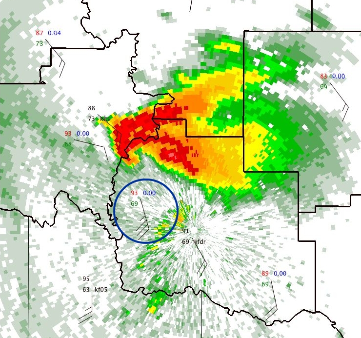
That is a very classic supercell sturcture, indeed.
The Tipton Mesonet site, featuring a 93 temp and 69 dewpoint, is
circled in blue. The Tipton rain gauge recorded zero precipitation
for the day, because the storm missed the station by several miles.
But that storm certainly exercised considerable influence on weather
conditions the station, as the following meteogram indicates:
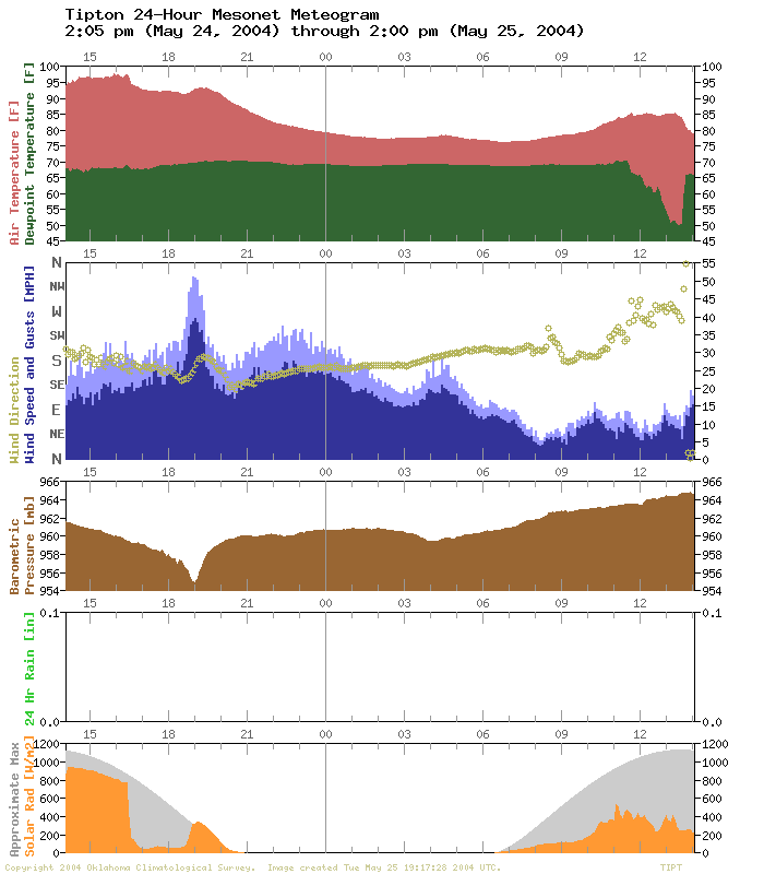
As the storm passed to the station's north, the winds stiffened
from around 20 mph to the 35-40 mph range. The station recorded
several gusts greater than 50 mph. The pressure bottomed out more
than four millibars below its environmental value (four millibars
may not sound like much, but that is significant!)
But the wind direction changed only slightly throughout the hour-long
episode. But ... notice that it veered from southeasterly to
southerly during the event.
So what was going on? The supercell was dominating the mesoscale
environment! That subtle veering of the winds was in response to
the passing supercell, which was sucking up inflow as it traveled
from west to east. For almost an hour, winds at Tipton simply
pointed toward the storm (and blew really hard!).
After the storm passed, its influence on the Tipton Mesonet site
waned. Conditions there returned to baseline values, and life went on.
Score yet another point for the value of meteograms ... and another
impressive capture by Dr. Basara.
May 26 in Mesonet History
| Record | Value | Station | Year |
|---|---|---|---|
| Maximum Temperature | 101°F | HOOK | 2006 |
| Minimum Temperature | 37°F | KENT | 2011 |
| Maximum Rainfall | 5.26 inches | HINT | 2000 |
Mesonet records begin in 1994.
Search by Date
If you're a bit off, don't worry, because just like horseshoes, “almost” counts on the Ticker website!