Ticker for April 6, 2004
MESONET TICKER ... MESONET TICKER ... MESONET TICKER ... MESONET TICKER ...
April 6, 2004 April 6, 2004 April 6, 2004 April 6, 2004
"Invisible" Heavy Rainfall in SW Oklahoma
On Friday afternoon, a very heavy storm north of Altus deposited
several inches of rainfall on the ground in a short time. The rains
came so quickly and heavily that the National Weather Service issued
a flash flood warning for the area.
Interestingly, the storm missed all of the Oklahoma Mesonet rain
gauges in the area, as seen in this image of radar-estimated
precipitation (Mesonet sites are noted):
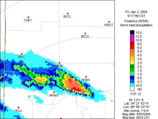
This phenomenon can be an occasional issue, especially in western
Oklahoma, where rainfall can come in the form of isolated, brief
and heavy downpours such as Friday's. It's rare to entirely miss
such heavy rains with a carefully-sited rain gauge network, but it
can happen.
In the long term, "undersampled" events like this one are balanced
out, and the long-term statistics are quite accurate.
April 6 in Mesonet History
| Record | Value | Station | Year |
|---|---|---|---|
| Maximum Temperature | 100°F | WALT | 2011 |
| Minimum Temperature | 14°F | EVAX | 2023 |
| Maximum Rainfall | 3.57 inches | OKMU | 2018 |
Mesonet records begin in 1994.
Search by Date
If you're a bit off, don't worry, because just like horseshoes, “almost” counts on the Ticker website!