Ticker for September 19, 2003
MESONET TICKER ... MESONET TICKER ... MESONET TICKER ... MESONET TICKER ...
September 19, 2003 September 19, 2003 September 19, 2003 September 19, 2003
More on Yesterday's Frontal Passage
OCS staffer Billy McPherson rounded up some good-looking Mesonet data
from yesterday's frontal passage. The following graphic shows a time
series from 6:00 am to 6:00 pm at each of five Mesonet stations that
observed the front in sequence:
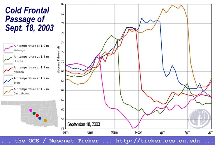
There are a couple of features that are worth noting.
First, notice that all of the stations were on roughly the same
temperature trace before the front's passage. Each station then
dropped off the trend as the front passed (around 9:00 am at Watonga,
10:00 am at El Reno, etc.).
Much of the graph is dominated by each of the five stations crashing
to a new temperature regime. However, by the end of the period, all
of the stations tended to settle in line with each other as they
accepted their new and colder reality.
Cool graphic!
September 19 in Mesonet History
| Record | Value | Station | Year |
|---|---|---|---|
| Maximum Temperature | 105°F | SEIL | 2024 |
| Minimum Temperature | 33°F | BEAV | 2003 |
| Maximum Rainfall | 4.19 inches | BBOW | 2002 |
Mesonet records begin in 1994.
Search by Date
If you're a bit off, don't worry, because just like horseshoes, “almost” counts on the Ticker website!