Ticker for September 11, 2003
MESONET TICKER ... MESONET TICKER ... MESONET TICKER ... MESONET TICKER ...
September 11, 2003 September 11, 2003 September 11, 2003 September 11, 2003
Heavy Rains in Western OK Spawn Flooding
Very heavy rainfall in and around Beckham County spawned several reports
of flash-flooding in the area, and the Salt Fork of the Red River
continues to swell from heavy morning rains.
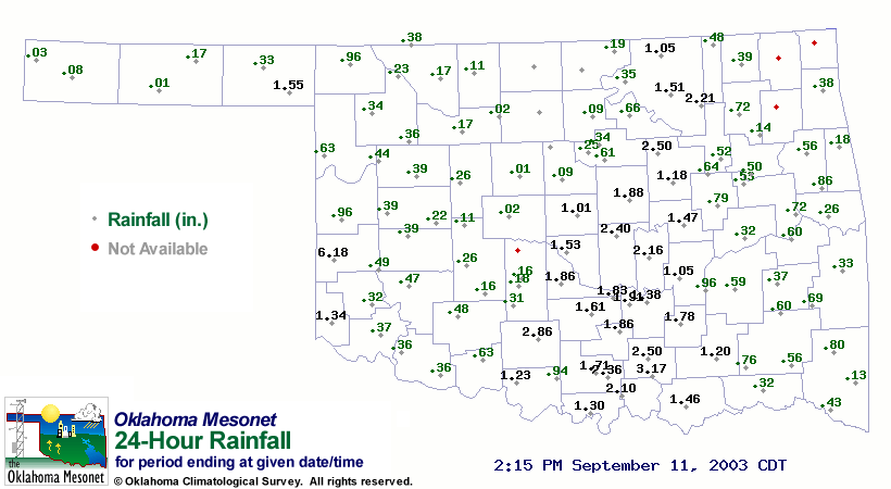
The Erick Mesonet station observed 6.18" rainfall, almost all of which
fell in two one-hour bursts. The value is the largest 24-hour total
observed at the Erick Mesonet site since it commenced operation in 1994.
A map of 24-hour rainfall totals (as of 2:15 pm) is available here:
Various flash-flooding problems have progressed west-to-east across the
state since last night. Moderate rainfall continues in far southeastern
Oklahoma as of 2:30 pm.
The event at Erick today places it in the top 25 one-day rainfall totals
in Mesonet history. The last 24-rainfall Mesonet exceeding Erick's was
August 30th at Medford, which recorded 7.93" in a day.
September 11 in Mesonet History
| Record | Value | Station | Year |
|---|---|---|---|
| Maximum Temperature | 109°F | FREE | 2000 |
| Minimum Temperature | 36°F | KENT | 2020 |
| Maximum Rainfall | 6.71 inches | PUTN | 2008 |
Mesonet records begin in 1994.
Search by Date
If you're a bit off, don't worry, because just like horseshoes, “almost” counts on the Ticker website!