Ticker for June 11, 2003
MESONET TICKER ... MESONET TICKER ... MESONET TICKER ... MESONET TICKER ...
June 11, 2003 June 11, 2003 June 11, 2003 June 11, 2003
Rain, Rain, Go Away
We always hear about farmers praying for rain, but sometimes that just
isn?t the case. This year, many of Oklahoma?s wheat farmers are saying
"enough, already".
During the past two weeks, much of the state?s wheat belt has received
more than enough rain. During other times of the year, this would be
welcome news. However, it poses tremendous problems in early June,
when many growers are trying to harvest their crop.
Ironically, Oklahoma?s abundant rainfall this season may be putting
the crop at risk. More than anything, wheat farmers could use a break
in the rain. Getting combines in and out of the fields is only part
of the problem. Wet wheat straw is difficult to cut, and damp grain
is difficult to thrash. Moreover, if the grain is harvested, elevators
often charge extra fees for - or reject altogether - excessively moist
grain. If the plant?s seed imbibes water, test weights will drop,
consequently lowering payments farmers receive at market.
According to Mark Hodges, the Executive Director of the Oklahoma Wheat
Commission, the June rains have had "a significant impact" on this year?s
crop. Despite an early start near the Red River in mid-May, only
about 25% of the state?s crop has been harvested, and test weights are
beginning to drop. "We?ve seen about a 2-5 pound per bushel loss in
south and central Oklahoma test weights," Hodges said. "Our only saving
grace so far has been that test weights were much higher than the
long-term average when the harvest started. That gave us a little
breathing room, but things still aren?t as good as they could have been.
We are concerned somewhat with quality loss."
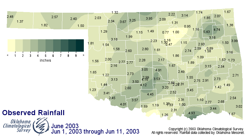
So, how much rain has fallen? Rainfall totals since June 1st across the
wheat belt, stretching from southwestern Oklahoma into north central
parts of the state, range up to four inches. The following Oklahoma
Mesonet rainfall maps illustrates why progress has slowed in the
southern wheat belt:
There is a silver lining to this situation: Oklahoma?s row crops and
pastures are benefiting from the rain. Many locations in the eastern
half of the state reduced a rainfall deficit of up to eight or more
inches since last fall.
The forecast for the next week calls for conditions that are typical
during June: humid days and chances for some locally heavy rainfall.
The National Weather Service indicates showers and thunderstorms
possible into early next week across much of Oklahoma. "We have
chances of rainfall in the forecast for the next seven days or so,"
said NWS forecaster Kenneth James. "As we approach each event, we?ll
be able to better see surface boundaries and other small-scale
conditions and we can refine our forecast accordingly."
The Ticker thanks OCS Senior Staff Climatologist Mark Shafer
for help getting today's issue started.
June 11 in Mesonet History
| Record | Value | Station | Year |
|---|---|---|---|
| Maximum Temperature | 108°F | ALTU | 2022 |
| Minimum Temperature | 44°F | KENT | 2004 |
| Maximum Rainfall | 6.05 inches | COPA | 2007 |
Mesonet records begin in 1994.
Search by Date
If you're a bit off, don't worry, because just like horseshoes, “almost” counts on the Ticker website!