Ticker for November 25, 2002
MESONET TICKER ... MESONET TICKER ... MESONET TICKER ... MESONET TICKER ...
November 25, 2002 November 25, 2002 November 25, 2002 November 25, 2002
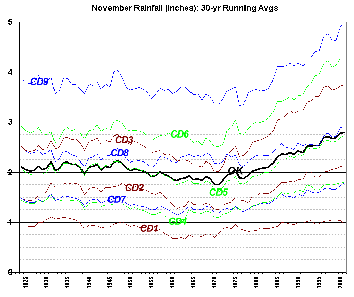
November in Oklahoma: Trending Wetter?
Frustrated by today's dry, northerly winds? Take solace in the fact
that November appears to be wetter lately across our great state.
The following graphic shows the 30-year running average precipitation
for the month (for instance, the 2001 value is the average November
rainfall during 1972-2001). The bold line is the statewide average,
and the thin lines represent each of the state's nine climate divisions.

( CD Key:  )
)
Notice that the statewide running 30-year average increased nearly
an inch in the last 30 years. This trend is supported by all nine
climate divisions, especially those in the eastern third of the state
(CDs 3, 6 and 9).
Coincidentally (or perhaps not coincidentally, and the Ticker hesitates
to open this can of worms), much of the last 30 years was dominated
by a positive phase of the Pacific Decadal Oscillation, or PDO.
The PDO is an index related to the sea-surface temperatures of the
northern Pacific Ocean to the equatorial eastern Pacific. "Positive
phase" refers to cooler surface waters in the north and warmer
equatorial waters (each compared to its own long-term average).
The PDO has been linked by some to climate trends in North America.
November 25 in Mesonet History
| Record | Value | Station | Year |
|---|---|---|---|
| Maximum Temperature | 78°F | WAUR | 2012 |
| Minimum Temperature | 6°F | HOOK | 2023 |
| Maximum Rainfall | 1.59″ | EUFA | 2010 |
Mesonet records begin in 1994.
Search by Date
If you're a bit off, don't worry, because just like horseshoes, “almost” counts on the Ticker website!