Ticker for July 23, 2001
MESONET TICKER ... MESONET TICKER ... MESONET TICKER ... MESONET TICKER ...
July 23, 2001 July 23, 2001 July 23, 2001 July 23, 2001
It's Official: Yesterday Was Year's Warmest
Yesterday's average statewide temperature of 88.03 F was the warmest
measured to date in 2001. The average temperature, computed from
Oklahoma Mesonet data, was the warmest since September 4th, 2000.
The average temperature was the 13th-warmest observed since the
Mesonet began full operations in 1994. That puts the day in the
99th percentile of hot days in Oklahoma. If there's such a thing as
the 99.5th percentile, it's in that, too.
The average statewide maximum temperature of 101.17 F was the year's
second-warmest (101.43, July 12th). Yesterday's maximum temperature
of 110 F at Cherokee matched the hottest Mesonet observation of the
year (Hollis, July 12th).
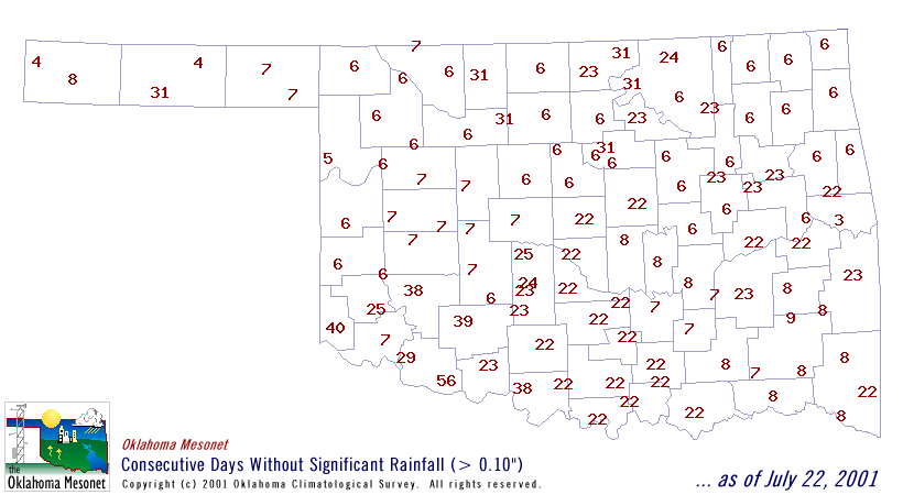
It is now more than a month since significant rainfall has fallen at
several Mesonet stations. A complete map is available at
July 23 in Mesonet History
| Record | Value | Station | Year |
|---|---|---|---|
| Maximum Temperature | 109°F | CHER | 2001 |
| Minimum Temperature | 54°F | ELRE | 2019 |
| Maximum Rainfall | 4.28 inches | TAHL | 2013 |
Mesonet records begin in 1994.
Search by Date
If you're a bit off, don't worry, because just like horseshoes, “almost” counts on the Ticker website!