Ticker for July 10, 2001
MESONET TICKER ... MESONET TICKER ... MESONET TICKER ... MESONET TICKER ...
July 10, 2001 July 10, 2001 July 10, 2001 July 10, 2001
Hot, Dry Summer Continues
100+ degree temps are plentiful across western Oklahoma today, the
eighth consecutive day that the century mark has been exceeded by
Oklahoma Mesonet stations. However, because the moisture content
is greater across eastern Oklahoma, heat indices are greater there.
For example, at 3 o'clock, the temperature/dewpoint of 98F/74F
at the Bee Mesonet station (near Tishomingo) produced a heat index
of 110F, while the 102F/47F couple at Hollis produced a heat index
of "only" 99F.
For all but the extreme northeastern counties, it's been more than
a week since one-tenth of an inch or rain has fallen. For many
Mesonet stations in north-central and southwest Oklahoma, it's been
since mid-June. Altus and Grandfield haven't recorded one-tenth
of an inch of rainfall since May 27th!
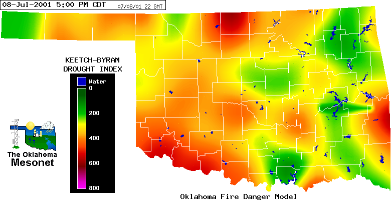
All of this is taking a toll on fire danger conditions. A Red Flag
Fire Alert has been issued for much of Oklahoma. Output from the
Oklahoma Fire Danger Model suggests that, for areas in southwest and
north-central Oklahoma, the top layers of the soil are drying to the
point that organic material in the soil itself could help fuel wildfire:
Thankfully, winds have been light in recent days, but with increased
wind sppeds comes increased fire danger.
More detail on the lack of rain and the fire danger situation will
come in tomorrow's Ticker.
July 10 in Mesonet History
| Record | Value | Station | Year |
|---|---|---|---|
| Maximum Temperature | 114°F | FREE | 2009 |
| Minimum Temperature | 55°F | EVAX | 2024 |
| Maximum Rainfall | 4.44 inches | MINC | 1996 |
Mesonet records begin in 1994.
Search by Date
If you're a bit off, don't worry, because just like horseshoes, “almost” counts on the Ticker website!