Ticker for October 2, 2000
MESONET TICKER ... MESONET TICKER ... MESONET TICKER ... MESONET TICKER ...
October 2, 2000    October 2, 2000    October 2, 2000    October 2, 2000


Extreme Fire Danger Conditions Return

Warm temperatures and stiff winds over the last week have erased almost
all effects of last weekend's rainfall across the midsection of the
state, and extreme fire danger conditions have returned, according to
data from the Oklahoma Fire Danger Model.

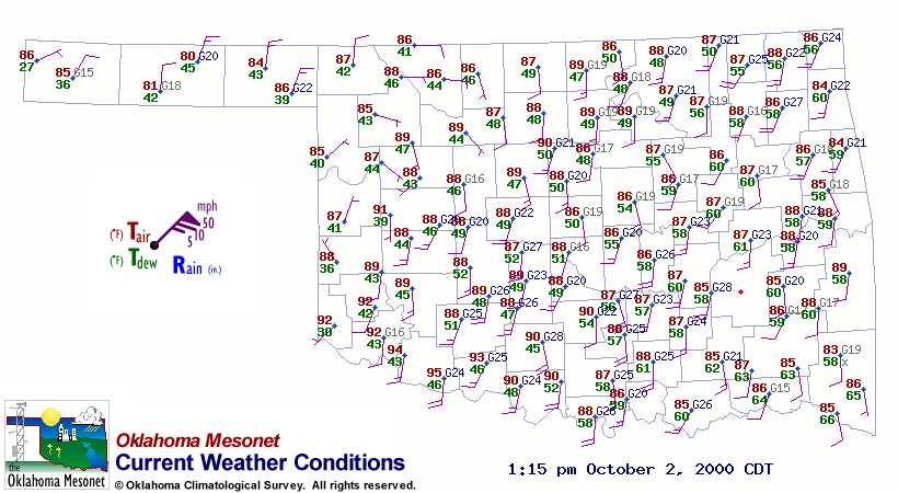
Gusty winds and dry air on either side of a cold front have escalated
fire danger conditions today.  A look at the afternoon wind field and
the OKFD Burning Index


show that, for the western two-thirds of the
state, the only temporary (and small) respite from extreme fire
conditions lies in the relatively calm winds of the frontal zone in
northwestern Oklahoma.


Rainless Streaks Extended

It has now been one week since any location in Oklahoma has received
significant rainfall, and today marks at least the 60th consecutive day
without significant rainfall for the following 31 stations (more than
one-quarter of the Oklahoma Mesonet):

64th day: Bessie
65th day: Butler, Camargo, Cheyenne, Erick, Grandfield,
Ketchum Ranch, Kingfisher, Marena, Marshall, Putnam,
Seiling, Watonga, Waurika, Weatherford, Wynona
66th day: Arnett, Breckinridge, Fairview, Perkins, Red Rock,
Stillwater
67th day: Blackwell, Burbank, Freedom, Medford
69th day: Guthrie
72nd day: Lahoma, Ringling
81st day: Hollis, Mangum


Coming Overnight: OCS Drought Assessment

A special issue of the OCS/Mesonet Ticker will arrive tonight during the
overnight hours, featuring a detailed assesment of the current drought,
with the latest statistics and some historical perspective.
October 2 in Mesonet History
| Record | Value | Station | Year |
|---|---|---|---|
| Maximum Temperature | 103°F | TIPT | 2000 |
| Minimum Temperature | 28°F | BOIS | 2009 |
| Maximum Rainfall | 4.76″ | CHER | 2002 |
Mesonet records begin in 1994.
Search by Date
If you're a bit off, don't worry, because just like horseshoes, “almost” counts on the Ticker website!