Ticker for May 17, 2000
MESONET TICKER ... MESONET TICKER ... MESONET TICKER ... MESONET TICKER ...
May 17, 2000 May 17, 2000 May 17, 2000 May 17, 2000
Sharp Dryline Advances in Western Oklahoma
A very sharp and very well-defined dryline is slowly pushing eastward
through western Oklahoma this afternoon.
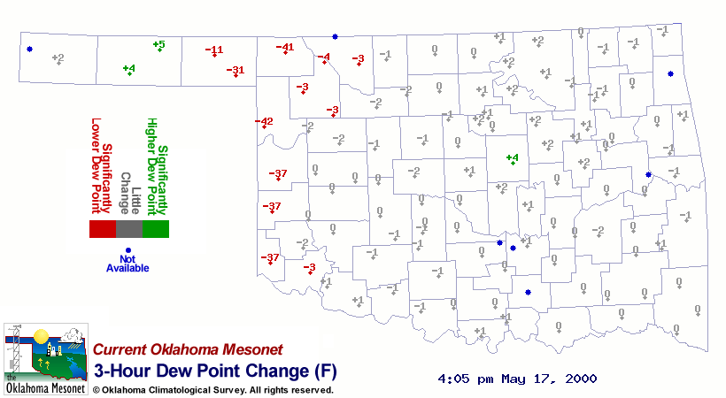
Relative humidities below ten percent are commonplace in the very dry
air west of the dryline. This dry air can be seen as significant drops
in the dewpoint temperature on the Mesonet three-hour change map:
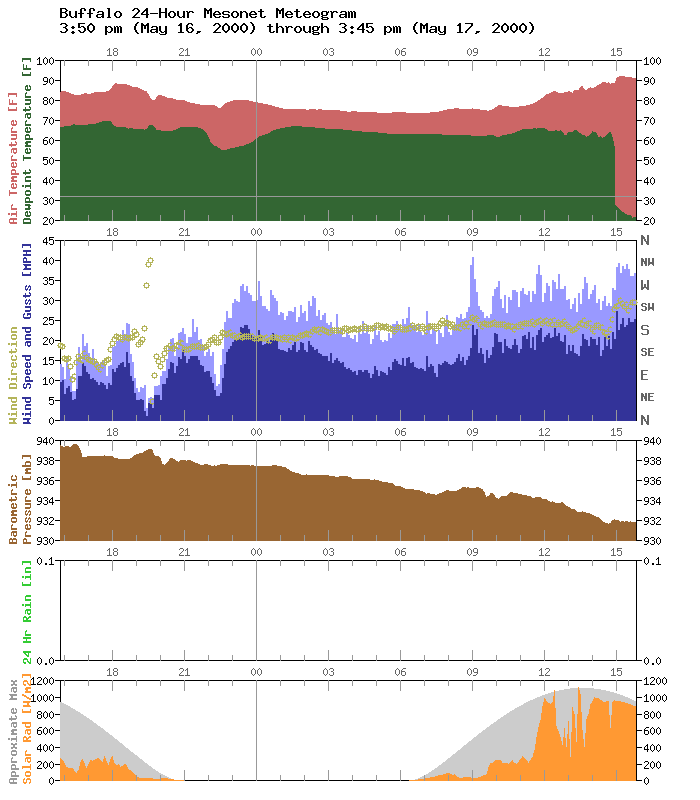
At Buffalo, the dryline passage is very noticeable on its 24-hour
meteogram as a very rapid decline in dew point (the green trace):
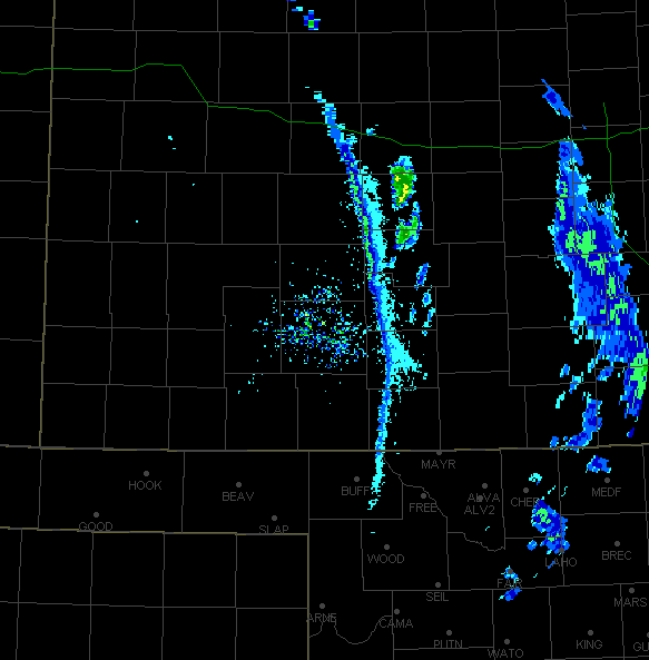
The moisture content and resultant density difference between the two
air masses is so significant that the boundary can be "seen" by radar,
even though no rain is falling, like in this reflectivity image from
Dodge City, Kansas:
Straight-line winds behind the dryline are very strong, and have
exceeded the threshold for severe thunderstorms (despite the lack of
convection) on several occasions this afternoon. Here's a list of
strong wind gusts as of 4:30 pm:
Slapout 55 mph 4:30 pm
Boise City 56 mph 4:20 pm
Boise City 57 mph 4:05 pm
Beaver 58 mph 3:55 pm
Goodwell 58 mph 3:55 pm
Beaver 58 mph 3:45 pm
Boise City 56 mph 3:20 pm
Kenton 58 mph 3:10 pm
Boise City 56 mph 2:55 pm
Kenton 58 mph 2:40 pm
Kenton 56 mph 2:35 pm
Kenton 56 mph 12:45 pm
Boise City 56 mph 12:30 pm
May 17 in Mesonet History
| Record | Value | Station | Year |
|---|---|---|---|
| Maximum Temperature | 101°F | HOLL | 2022 |
| Minimum Temperature | 37°F | CAMA | 2009 |
| Maximum Rainfall | 3.66 inches | PORT | 2002 |
Mesonet records begin in 1994.
Search by Date
If you're a bit off, don't worry, because just like horseshoes, “almost” counts on the Ticker website!