Ticker for August 16, 1999
MESONET TICKER ... MESONET TICKER ... MESONET TICKER ... MESONET TICKER ...
August 16, 1999 August 16, 1999 August 16, 1999 August 16, 1999
The Inevitable Moisture Return
After a delightful weekend respite from brutal heat indices, it looks
like high temperatures and high dewpoints are returning to the state
en masse today. At 1:30 pm today, three distinct moisture zones were
visibile in the Mesonet weather map:
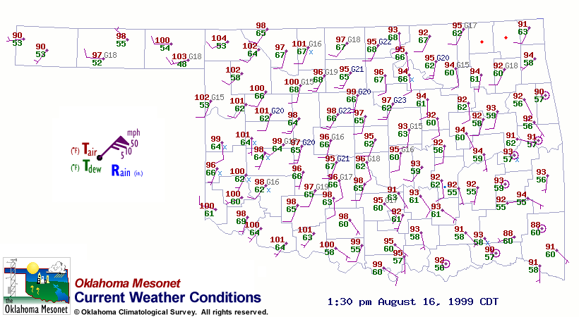
In the southeastern 30-40% of the state, the final remnants of our
weekend airmass are holding out. Temps around 90 and dewpoints in the
50s are bowing out of the state as more typical summer values stream
into the state from the southwest. The Panhandle is experiencing a
push of drier air from the west.
That's what's going on in what some would call an unremarkable day.
It's not very often that dew point temps are ten degrees lower in
McAlester than in Erick on an August afternoon!
August 16 in Mesonet History
| Record | Value | Station | Year |
|---|---|---|---|
| Maximum Temperature | 108°F | MANG | 2024 |
| Minimum Temperature | 53°F | BRIS | 2016 |
| Maximum Rainfall | 3.48 inches | KENT | 2010 |
Mesonet records begin in 1994.
Search by Date
If you're a bit off, don't worry, because just like horseshoes, “almost” counts on the Ticker website!