Ticker for December 19, 2016
MESONET TICKER ... MESONET TICKER ... MESONET TICKER ... MESONET TICKER ...
December 19, 2016 December 19, 2016 December 19, 2016 December 19, 2016
Coldest day since when?
Hello December 18, 2016, meet February 10, 2011. The -18 degrees recorded Sunday
morning at the Eva and Beaver Mesonet sites are the lowest temperatures seen in
the state since that fateful Feb. 10th. As you may remember (if you're lucky,
you weren't living here at the time), Feb. 10th was the day we recorded our
lowest temperature in state history, -31 degrees at the Nowata Mesonet site. Here
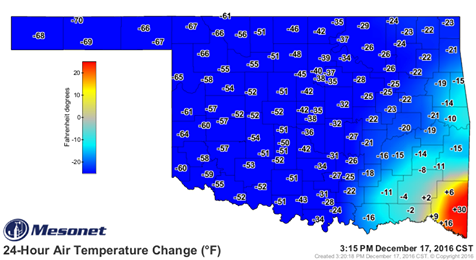
are the maps from Sunday and Feb. 10th for comparison.
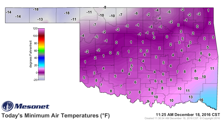
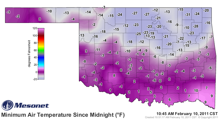
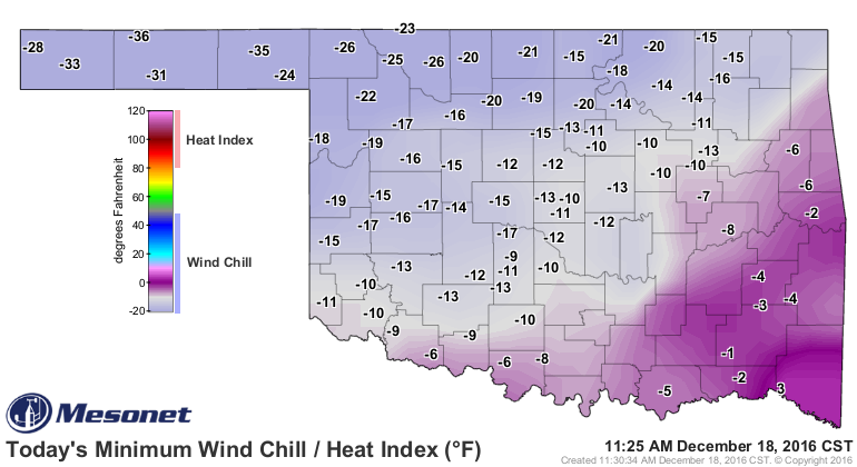
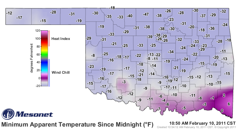
And while that February day some 6 years ago was obviously much more frigid across
a large portion of the state, Dec. 18th was no slouch. And the wind chill maps
were similar as well. The -47 at Medford back on Feb. 10th was the lowest ever
recorded for the Mesonet, but Dec. 18th was close on its heels with the -36
degrees at Eva.
To say this arctic blast was all it was made out to be would underwhelm its
reality. At one point, the Mesonet had recorded a 70 degree temperature swing
at, again, Eva.
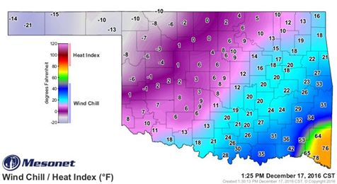
Also on the 17th, the apparent temperature (the "feels like temperature"...wind
chill/heat index)varied by 99 degrees across the state. From -21 at Boise City
to 78 at Idabel.
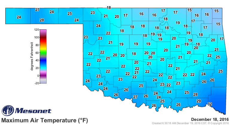
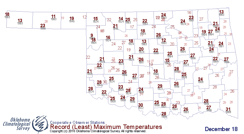
And not to be outdone, yesterday's high (HAHAHA!) temperatures broke records
by remaining in the teens and 20s across the state.
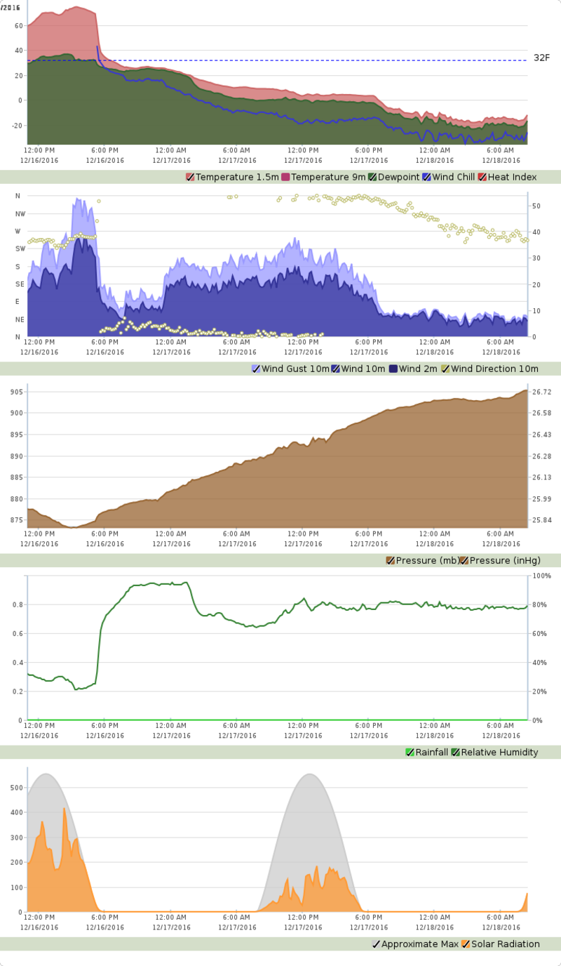
By the way, do you want to see a bad 24 hours or so. Again, let's go back to
Eva (figuratively, not literally) and take a look at their descent from a high
of 75 degrees at 3:30pm on Dec. 16th to a low of -18 degrees at 3:15am on Dec.
18th. And the absence of a windchill at 5:30pm on the 16th to a windchill of
-36 degrees at 2:50am on the 18th. (TOP GRAPH)
You can also see the switch over from SW winds gusting to over 50 mph before
the front bringing up all that warm air, then the abrupt swing to northerly
winds gusting to 30mph+ after the front. (SECOND GRAPH).
The third graph shows the pressure as it steadily rose as the surface low passed
very close to the station, ushering in the warm air ahead of it and the cold air
(and high pressure) after its passing.
So we've seen our coldest day in the state since Feb. 10, 2011. Overall, Dec.
18, 2016, was the 55th coldest day in state history based on the statewide
average (i.e., take all the highs and lows for a particular day across the
state and average them all together) at 11.6 degrees. Feb. 10, 2011 was actually
a disappointing 38th (tied with 4 others) at 10.6 degrees, but Sunday was only
a degree off. Here are your top-5 coldest days in state history, with a the
recent ones thrown in.
-***-
Rank Date Statewide Avg.
1. 12/22/1989 1.9F
2. 12/22/1983 3.5F
3. 12/23/1989 3.6F
4. 12/24/1983 4.2F
5. 01/04/1947 4.7F
30. 02/02/2011 10.0F
32. 02/03/2011 10.1F
38. 02/10/2011 10.6F
55. 12/18/2011 11.6F
58. 02/06/2014 12.1F
77. 03/03/2014 13.5F
-****-
So how do you say that? Coldest day since March 3, 2014? Coldest day since Feb.
10, 2011? Does it really matter? Let me put it another way.
IT WAS TOO COLD!
And now, the game is afoot. It does look like a storm system will pass through
over the weekend, bringing moisture to the region on Christmas Eve and Christmas.
Will there be cold air in place for snow, or just a cold rain? Well, from what
the forecasts are starting to pinpoint now, get ready for...Christmas
thunderstorms, possibly? From the Tulsa NWS:
"The forecast will be trended toward a
warmer scenario from late week through the weekend along with
increasing precip chances. Aside from a large shift in the
presence of colder air, this pattern would keep any frozen precip
will north of the region with the associated warmth and moisture
return raising thunderstorm potential for late in the weekend."
Hope Santa has that sleigh lightning-proofed!
Gary McManus
State Climatologist
Oklahoma Mesonet
Oklahoma Climatological Survey
(405) 325-2253
gmcmanus@mesonet.org
December 19 in Mesonet History
| Record | Value | Station | Year |
|---|---|---|---|
| Maximum Temperature | 75°F | IDAB | 2012 |
| Minimum Temperature | -10°F | EVAX | 2016 |
| Maximum Rainfall | 2.94″ | BUTL | 2006 |
Mesonet records begin in 1994.
Search by Date
If you're a bit off, don't worry, because just like horseshoes, “almost” counts on the Ticker website!