Ticker for November 8, 2011
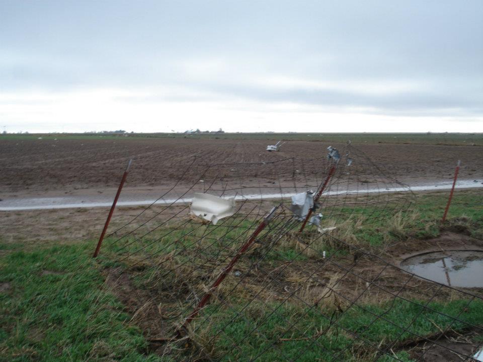
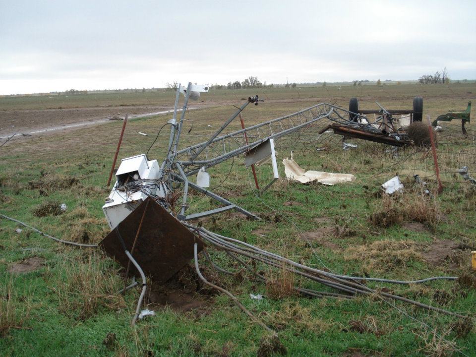
UPDATE: Oklahoma Mesonet technicians sent back pictures from the Tipton Mesonet
site struck by the tornado yesterday afternoon.
Picture #1 shows the approximately 100+ pound auxiliary battery box from the
site tossed into the adjoining field.
Picture #2 shows the mangled 30 foot Mesonet tower laying on the ground.
Watch for more updates on the Mesonet's Facebook page.
http://www.facebook.com/mesonet
MESONET TICKER ... MESONET TICKER ... MESONET TICKER ... MESONET TICKER ...
November 8, 2011 November 8, 2011 November 8, 2011 November 8, 2011
Two Oklahoma Mesonet sites leveled by tornadoes
Mother Nature has been angry, my friends. Record drought, heat, tornadic
activity, hailstones, snowstorms, heat (we like heat), flooding, earthquakes ...
all have been in the offering plate for Oklahoma during 2011. The entire Ticker
staff has been trying to figure out what she has against Oklahoma Mesonet
sites in particular, however. Remember back in May an EF5 tornado brushed the
El Reno Mesonet site, giving us Oklahoma's highest ever non-radar recorded wind
speed of 151 mph. Well this time there was more than a glance.
From OCS Associate Director for Mesonet Dr. Chris Fiebrich:
"Never in Mesonet history has a site been leveled by a tornado, but
it appears to have happened twice yesterday. We have eyewitness
reports from the OSU Caddo Research Station that our Fort Cobb Mesonet
station is laying on the ground, covered by debris. That debris
includes an irrigation pivot from a nearby field."
"Our Mesonet station at Tipton, located on the OSU Agronomy Research
Station, appears to have also been leveled. The site is usually
visible from the roadway, but eyewitnesses report they can no longer
see it. Our station was just a short distance to the west of an
OSU farmhouse and barn that were destroyed at the Research Station
yesterday."
Obviously we lost communications with both stations when they were hit, and they
were not able to transmit their data to us before the damage. We have Mesonet
technicians en route to both sites this morning to attempt a data retrieval and
see if the tornadic winds were recorded.
Keep in mind that these sites are probably going to be down for awhile. Both of
these sites are difficult to get to WITHOUT debris getting in the way. We hope
to have pictures of those sites available when the Mesonet technicians arrive.
Be sure to watch our Facebook page for sneak previews.
http://www.facebook.com/mesonet
***************************************
Serious rains for serious drought
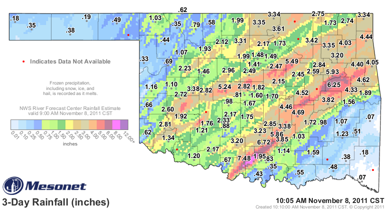
Oklahoma's rainfall totals for the last few days are gargantuan in some places,
very beneficial in most places, and very little in a few places. Although rain
is moving through southeastern Oklahoma now, that area missed out on the best
moisture with around a half of an inch or so at most stations. The Panhandle and
northwest were also left on the meager-total side, although Buffalo (the best
little town in the universe) managed to eek out 1.2". The best totals were
confined to a couple of streaks from south central up through northeastern
Oklahoma and then southwest through north central. The totals for the southeast
should continue to go up as the rain moves through that area.
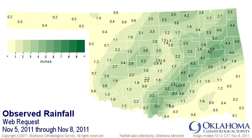
The flooding that closed Deer Creek schools in northern Oklahoma County was
captured by a CooCoRaHS observation of 6.1 inches from that area. Here is a map
of 24-inch amounts from the CoCoRaHS volunteer network.
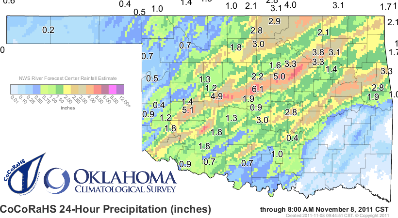
Here are the top-10 totals from the Oklahoma Mesonet through this morning.
Ringling 7.48" Jay 4.26"
Sulphur 6.72" Foraker 4.24"
Haskell 6.11" Tahlequah 4.22"
Vanoss 5.86" Pryor 4.01"
Porter 5.78" Okmulgee 3.96"
Oilton 5.49" Cookson 3.92"
El Reno 5.24" Fittstown 3.85"
Holdenville 4.69" Westville 3.79"
Okemah 4.52" Eufaula 3.76"
Bowlegs 4.46" Webbers Falls 3.75"
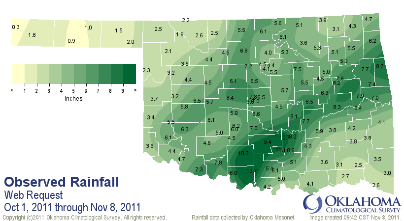
Of the 120 Oklahoma Mesonet stations (minus those pulverized by tornadoes),
54 received more than 2" of rainfall. Combined with October, a substantial
portion of the state has received substantial rainfall. A few areas have nearly
doubled what they received for the previous nine months.
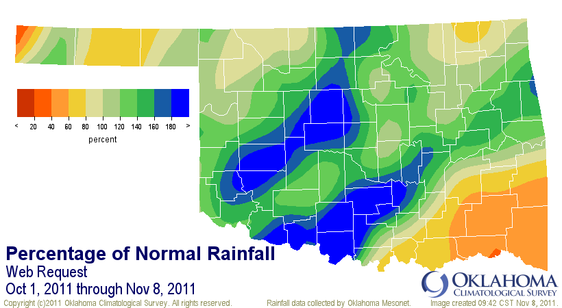
These rains are fantastic and should come in quite handy should dry conditions
re-emerge for those areas. And as we celebrate those totals, let's remember
those folks that missed out on the beneficial rains yet again. They will always
have a voice here.
Gary McManus
Associate State Climatologist
Oklahoma Climatological Survey
(405) 325-2253
November 8 in Mesonet History
| Record | Value | Station | Year |
|---|---|---|---|
| Maximum Temperature | 92°F | FREE | 2006 |
| Minimum Temperature | 19°F | BOIS | 2000 |
| Maximum Rainfall | 3.96″ | TALI | 2011 |
Mesonet records begin in 1994.
Search by Date
If you're a bit off, don't worry, because just like horseshoes, “almost” counts on the Ticker website!