Ticker for July 17, 2009
MESONET TICKER ... MESONET TICKER ... MESONET TICKER ... MESONET TICKER ...
July 17, 2009 July 17, 2009 July 17, 2009 July 17, 2009
Brrrrrrrr!
Okay, the latest heat wave has been interrupted for a spell, but it is summertime
in Oklahoma so don't be shocked when it makes it's return appearance. When
Mother Nature gives you a decent cold front in July, say thanks graciously and
move on! After all, it's not nice to fool...no wait, I did that joke already.
We had a request from a Ticker reader asking about the highest average
temperatures in the 15-year history of the Mesonet. We like requests from
readers, so continue to send those in.
When we talk about average daily Mesonet temperatures, remember that we are
blessed with 5-minute data, so we can get a true average. This differs from,
say, average daily temperatures from COOP sites, which are simply the average
of the Daily Max and Daily Min temperatures. So our daily average temperatures
are going to be a bit higher at times than a simple (TMAX + TMIN)/2 average
since that oft-fleeting sudden drop in temperature around dawn will be "erased"
by the observations on either side of the time scale. Example, the Buffalo
meteogram from July 10, 2009:
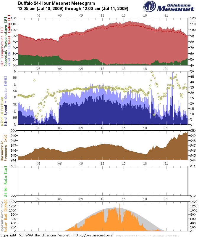
If you calculated the (TMAX + TMIN)/2 average, like COOP data, the average
temperature would be 96.5 degrees. What would it be Mesonet-style? Read on...
Okay, channeling Bugs Bunny:
Overture, curtain, lights
This is it, to hit the average highs
And, O what average highs we'll hit
On with the show, this is it!
The all-time top-20 highest Mesonet average temps are (drum roll please):
BUFF: 7/10/2009 98.99
FREE: 7/10/2009 98.55
GUTH: 7/6/1996 97.69
FREE: 7/6/1996 97.34
FAIR: 7/6/1996 97.26
TIPT: 6/27/1994 96.73
MEDI: 7/7/1996 96.68
ALV2: 7/10/2009 96.66
REDR: 7/6/1996 96.57
KING: 7/6/1996 96.56
SEIL: 7/6/1996 96.46
MEDI: 7/6/1996 96.42
BLAC: 7/6/1996 96.41
BREC: 7/6/1996 96.3
WOOD: 7/10/2009 96.23
WYNO: 7/6/1996 96.22
ALTU: 6/27/1994 96.13
SHAW: 7/6/1996 96.12
MEDF: 7/6/1996 96.06
NORM: 7/6/1996 96.01
So Buffalo wins the prize! In addition to it providing the state of Oklahoma
with its greatest associate state climatologist that ever served between June
1-July 17, 2009 (not to be diminished by the fact I'm the ONLY associate state
climatologist for Oklahoma serving between June 1-July 17, 2009), its highest
snowstorm total ever (36 inches in February 1971), and its highest 24-hour
snowfall ever (23 inches, February 1971), it now garners a heat-related Mesonet
record as well.
Obviously those records are all related to our biggest heat waves since the
Mesonet began in 1994. There are really two that stand out with such
drastically high temperatures...the July 1996 event and the July 2009 event.
Of course, Tipton has to show off and sneak in there at #6 from June 27, 1994,
the date it tied the state's all-time record high temperature with 120 degrees.
By the way, that 24-hour snowfall record is going to fall as soon as a group of
experts from the federal and Oklahoma governments can convene a committee to verify
some snow measurements from the late-March snowstorm in northwestern Oklahoma.
Get ready Slapout...you're about to be famous! I promise you a future Ticker
when that news breaks.
That's it for this Ticker. Enjoy the cold wave this weekend!
Gary McManus
Associate State Climatologist
Oklahoma Climatological Survey
http://www.mesonet.org/
http://okc.mesonet.org/
http://twitter.com/ocsticker
http://www.facebook.com/group.php?gid=80762543949
http://www.facebook.com/group.php?gid=2204800994
July 17 in Mesonet History
| Record | Value | Station | Year |
|---|---|---|---|
| Maximum Temperature | 111°F | HOLL | 2022 |
| Minimum Temperature | 54°F | KENT | 2009 |
| Maximum Rainfall | 6.42″ | BURB | 1997 |
Mesonet records begin in 1994.
Search by Date
If you're a bit off, don't worry, because just like horseshoes, “almost” counts on the Ticker website!