Ticker for May 15, 2014
MESONET TICKER ... MESONET TICKER ... MESONET TICKER ... MESONET TICKER ...
May 15, 2014 May 15, 2014 May 15, 2014 May 15, 2014
Yeah, but it's a dry cool
Most avid Ticker readers (Hi Mom!) know of my disdain for cooler weather, so
the last few days have been unwelcome, greatly!, by me. Look at these low
temperatures for the past couple of days, after all.
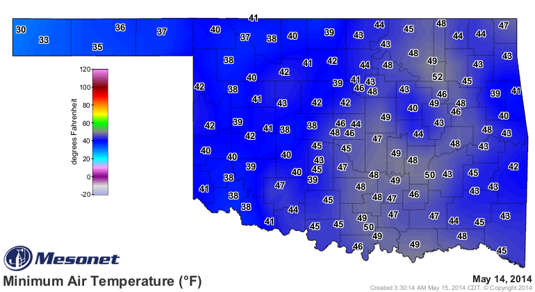
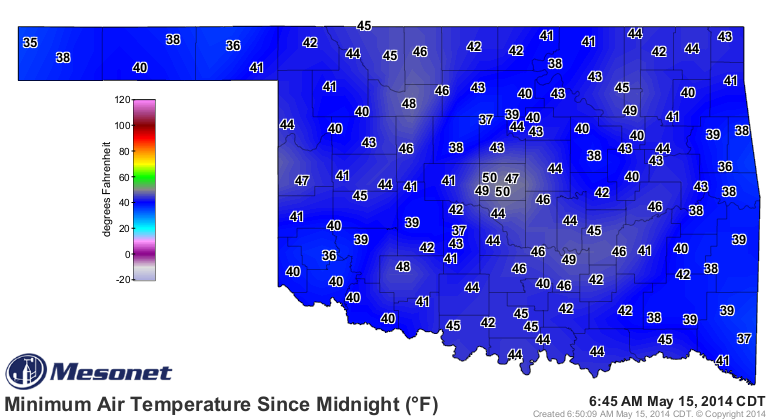
There was even a freeze in the OK Panhandle yesterday, for crying out loud! Now
I keep hearing how nice this weather is with the lows in the 40s and the highs
in the 60s and 70s as well.
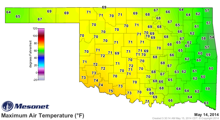
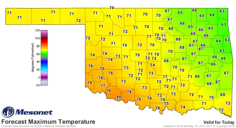
Normal highs and lows for this time of year are in the 80-ish and 60-ish range,
respectively, so we're about 10-15 degrees below normal. For those folks "loving"
this weather, let me tell you why they're wrong! And the strawberries, too.
that's where I had them. They laughed at me and made jokes but I proved beyond
the shadow of a doubt and with... geometric logic...
Whoa, I went all Captain Queeg there in my excitement ("The Caine Mutiny,"
anyone? Humphrey Bogart? Fred MacMurray? Never mind.). Back to why this cold
weather is bad.
Because we need rain, and lots of it. The current pattern we are in has
scoured the atmosphere of moisture and kept the return of such at bay from the
Gulf of Mexico. There are still light showers appearing each day thanks to
cool air aloft and the daytime heating of the surface creating instability,
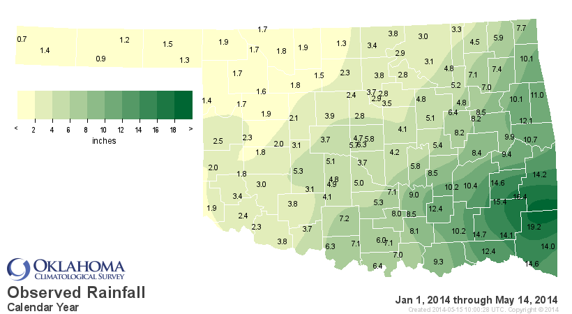
but the amounts are just too light in this cool, dry air. Just look at the
first 15 days of May, smack dab in the middle of Oklahoma's wettest season (at
least for most of the state) that tends to last through about mid-June.
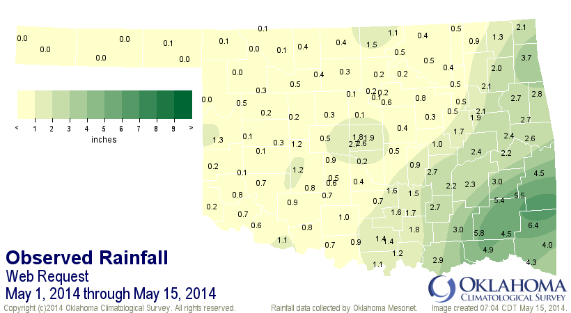
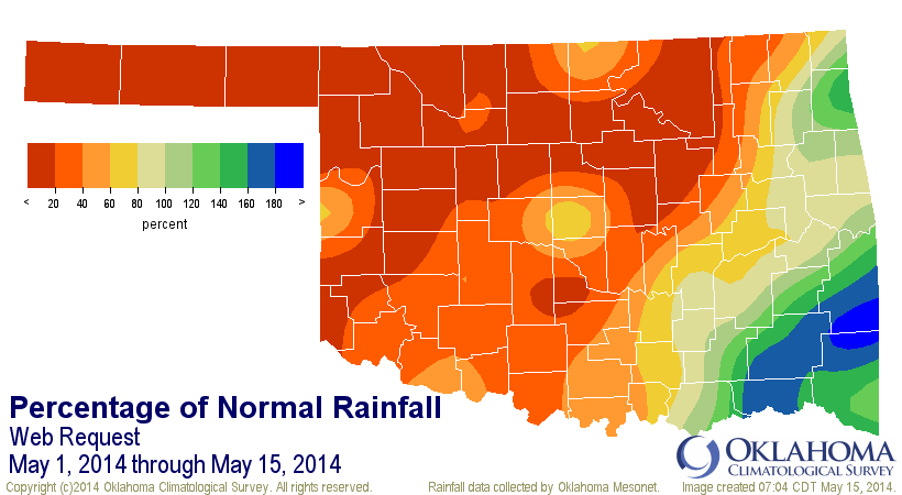
While the statewide average is about 1.3", that's still 1.2" below normal, or
about 50% of normal. And you can tell from the maps, almost all of even that
meager statewide total is due to heavy rains down in the southeastern corner
of the state. Again, we are dealing with a horrible spring and year-to-date
thus far when it comes to moisture.
Here are the spring maps (climatological spring, which begins March 1).
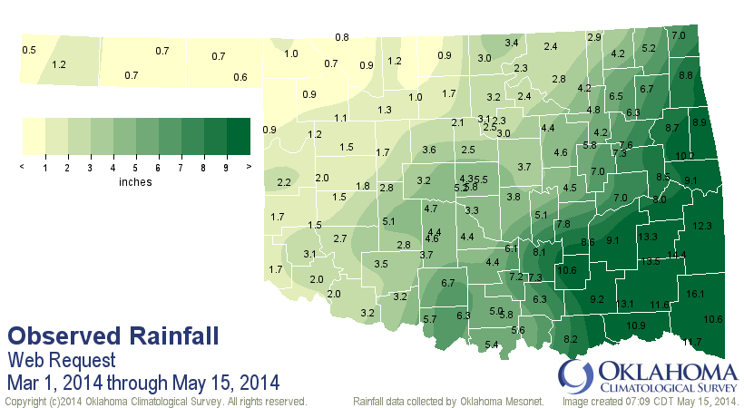
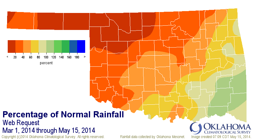
Once again, the SE leads the way. For the Panhandle and NC Oklahoma, this spring
thus far has been the driest since 1921 for those areas with area-wide averages
of 0.8" and 1.5", respectively (or 16% and 20% of normal, respectively).
The year-to-date is even worse (through yesterday).
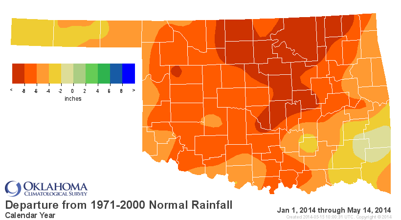

I would quote you the stats, but check them out for yourself. Lots of "1st driest
since 1921) in there.
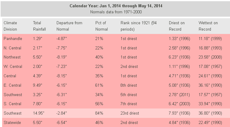
Yep, for the Panhandle, NC, NE and Central climate divisions, they are seeing
their driest such period since 1921. WC is quite the flower with their second
driest. Overall, the second driest Jan 1-May 14 since 1921 with a statewide
average of 5.5", 6.5" below normal. Only the 1936 period was drier with 4.8".
1936 (if only I could put numbers in all CAPS for effect)!! Trust me, 1936 is
NOT (see how I did that?) a year you want to be hanging out with. Your Mothers
would tell you that you need to find better friends to run around with ... no
1930s or 1950s.
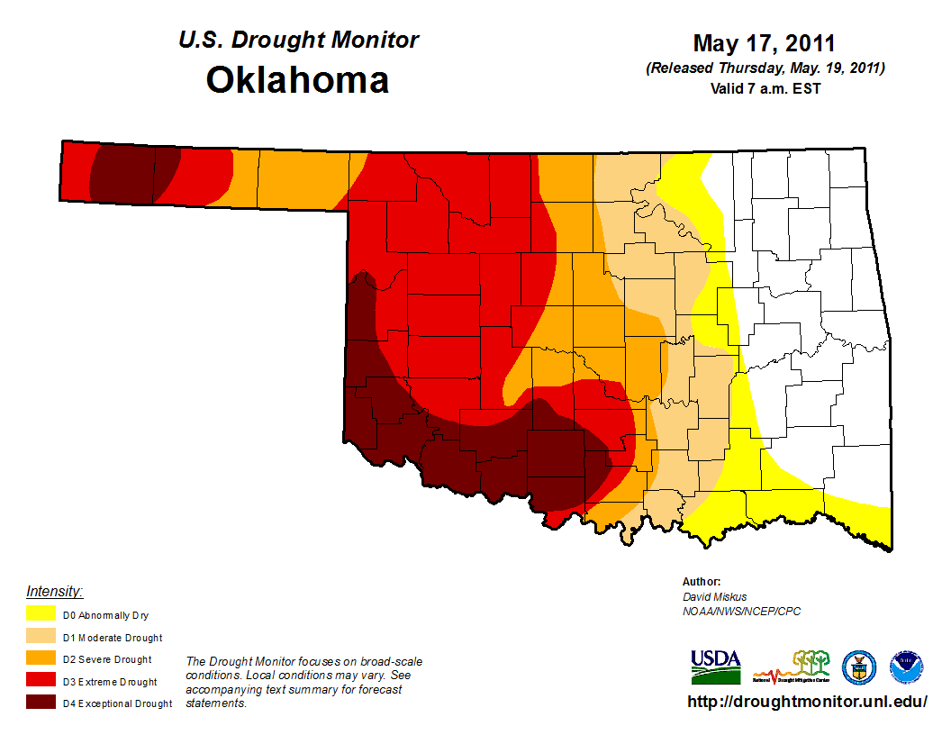
All that brings us to the latest U.S. Drought Monitor map, which saw some
improvements in the SE where the best rains fell, and some deterioration in
NC OK where the deficits continue to mount. There was also a bit of improvement
across Grady and Caddo counties where up to 4 inches fell with a series of
training storms.

So we now have 50% of the state in at least Extreme (D3) to Exceptional (D4)
drought, and 65% in at least Severe (D2) drought. What's scary is that it looks
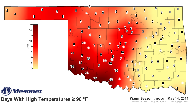
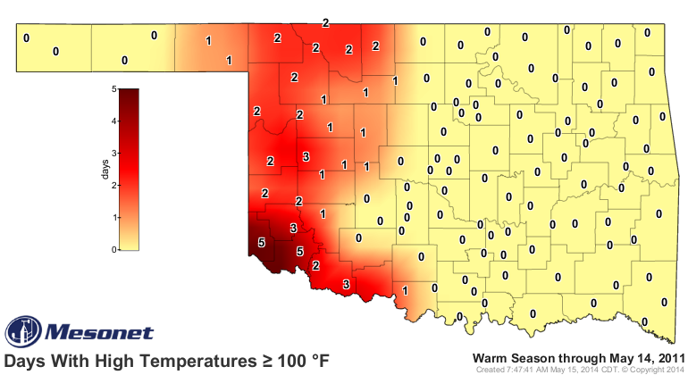
so 2011-ish to me. Here's the map from this time back in 2011.
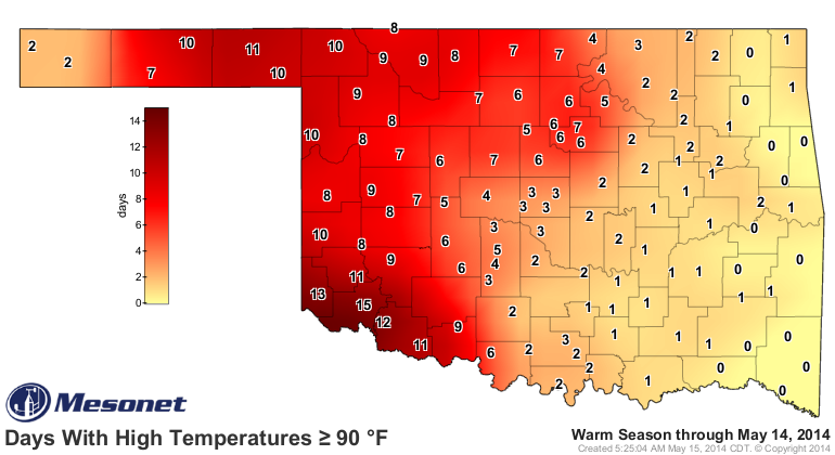
One thing that HAD been different between this year and 2011 was the heat. Now
even those statistics are starting to catch up. Check out the days above 90
degrees and 100 degrees between the two similar periods, 2011 vs. 2014.
2011
2014

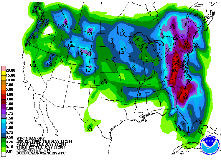
Okay, enough horrible comparisons with 2011. Even I'm not that crazy of a
warminista. What do we see in terms of rainfall for the next 7 days? Well, not
nearly enough. It looks nice and green, but trust me, this is a mere pittance
for this time of year.
There might be some hope after that. The 6-10 and 8-14 day outlooks from CPC
show increased odds of above normal precipitation through those periods (let's
hope that doesn't mean the bad stuff that comes with rain in May, but hey ...
it is Oklahoma).


There's your hope on the horizon portion of today's Ticker. Not quite so much
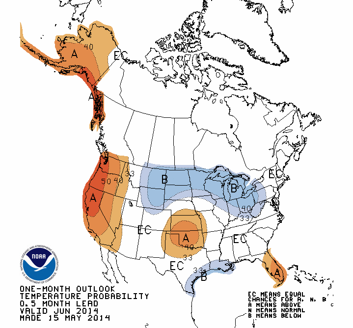
optimism for the June and Summer outlooks, but there's just a tad of hope in
there (although both periods look warmer than normal to CPC). And a bit of
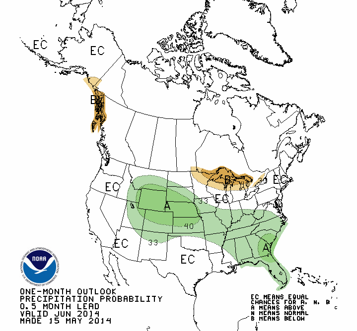
increased odds of above normal precip for northern Oklahoma during June.
June Outlooks
Summer (June-August) Outlooks

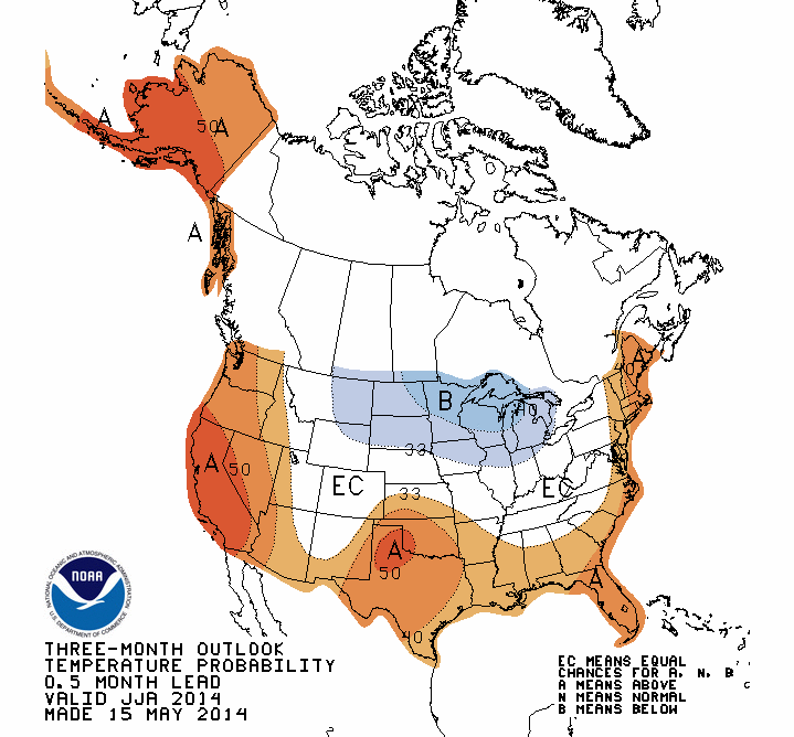
Remember, the white "Equal Chances (EC)" area does not mean they expect normal
rain amounts. That's a signal that above-, below- and near-normal precip amounts
all have equal chance of occurring.
That all leads to the newest Season Drought Outlook. This is a figure that say
"what do we think the drought will look like at the end of August?" Well, it
ain't pretty if you're in drought right now in Oklahoma. That drought is
expected to persist or even intensify through the summer.

That would be bad news for Oklahoma, of course, and PROBABLY mean a scorcher.
Extreme drought normally goes hand-in-hand for Oklahoma.
Now, back to those missing strawberries!
Gary McManus
State Climatologist
Oklahoma Mesonet
Oklahoma Climatological Survey
(405) 325-2253
gmcmanus@mesonet.org
May 15 in Mesonet History
| Record | Value | Station | Year |
|---|---|---|---|
| Maximum Temperature | 104°F | GRA2 | 2022 |
| Minimum Temperature | 32°F | BOIS | 2011 |
| Maximum Rainfall | 5.38″ | KETC | 2020 |
Mesonet records begin in 1994.
Search by Date
If you're a bit off, don't worry, because just like horseshoes, “almost” counts on the Ticker website!