Ticker for January 28, 2013
MESONET TICKER ... MESONET TICKER ... MESONET TICKER ... MESONET TICKER ...
January 28, 2013 January 28, 2013 January 28, 2013 January 28, 2013
Magnificent, glorious warmth
What do you do when all your wildest dreams are realized? Well, you keep it to
yourself, of course. But some things are worth shouting about, like the recent
temperatures. I know there are ramifications to that warmth ... it certainly
doesn't help the drought situation. I have been craving some warm weather,
however, and warmth is what we have for a few days. The highs yesterday were very
March-like (heck, April across far western Oklahoma). We even had an 80 register
on the Mesonet down in Hollis.
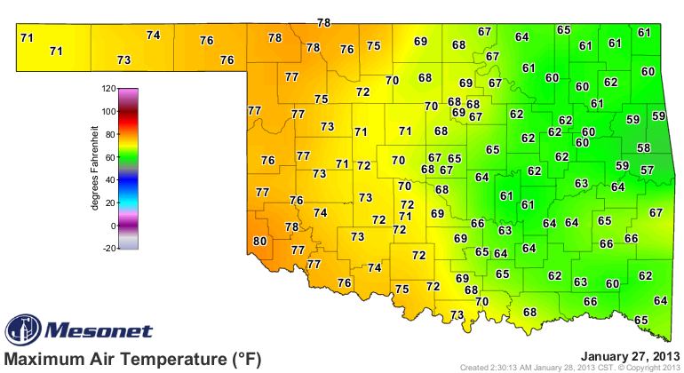
That 80 in Hollis is the highest temperature recorded by the Mesonet since Dec.
3 (many stations eclipsed 80 degrees that day).
High dewpoints helped keep low temperatures overnight about 10 degrees warmer
than the normal highs, for crying out loud (quick science bit ... when the air
temperature drops down to the dewpoint temperature, moisture starts to condense,
which releases heat, which keeps the air temperature from dropping below the
dewpoint temperature, which makes the dewpoint temperature a useful guide
sometimes in forecasting low temperatures)! Just check how the dewpoints and
air temperatures match up.
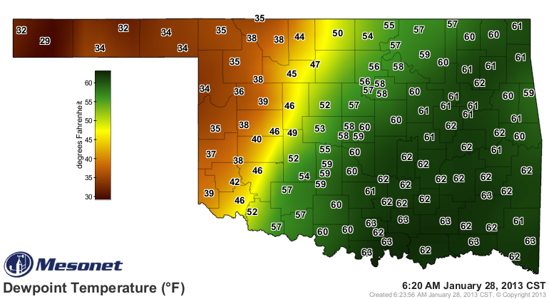
(quick science bit #2 ... the water vapor in the air is a very efficient
absorber of infrared radiation, or heat energy, so it also helps trap the heat
radiating from the surface, NEAR the surface)
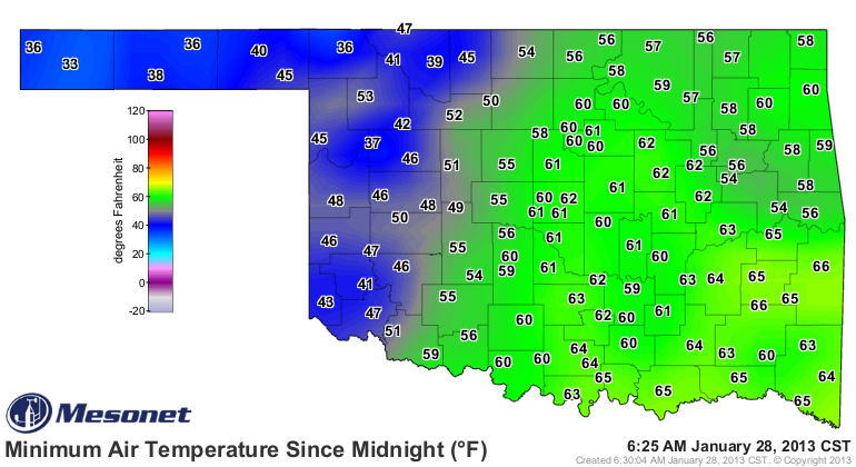
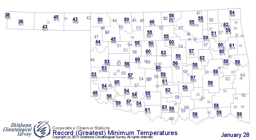
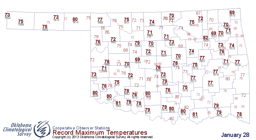
If those low temperatures can hold throughout the day, and it looks like they
will, then some areas of the state have come close to setting records for
highest minimum temperatures for January 28.
We now look towards daytime highs that will be about 20-25 degrees above normal.
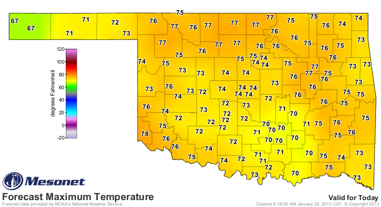
If those temperatures materialize, they will get close to or break the record
high temperatures for Jan. 28 in some areas.
Now I know this type of weather doesn't help the drought situation, but it is
due to an approaching storm system. That storm system will bring a chance of
rain for the eastern parts of the state, probably in the form of a squall line
tomorrow morning. You can see on the 7-day rainfall total forecast from the
HPC that western Oklahoma gets the empty rain gauge treatment once again.
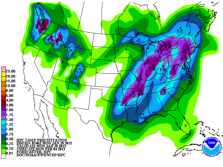
I'm afraid that's gonna be the last chance of rain for the next week or so. It's
great for those that get some. For those that don't, keep trudging along. Like
eating cake while on a diet ... squash the guilt and enjoy the warmth.
Gary McManus
Associate State Climatologist
Oklahoma Climatological Survey
(405) 325-2253
gmcmanus@mesonet.org
January 28 in Mesonet History
| Record | Value | Station | Year |
|---|---|---|---|
| Maximum Temperature | 83°F | MANG | 2015 |
| Minimum Temperature | -1°F | BUFF | 2009 |
| Maximum Rainfall | 2.87″ | TIPT | 2010 |
Mesonet records begin in 1994.
Search by Date
If you're a bit off, don't worry, because just like horseshoes, “almost” counts on the Ticker website!