Ticker for August 30, 2023
MESONET TICKER ... MESONET TICKER ... MESONET TICKER ... MESONET TICKER ...
August 30, 2023 August 30, 2023 August 30, 2023 August 30, 2023
Dust Riders

A horrible force of nature, responsible for destruction on a scale unfathomable
to most Oklahomans.
No, not Taco Bell, but it would be a fair description. Can toilets be declared
FEMA disasters?
Hurricanes. Think of them as giant heat transfer engines, churning through the
atmosphere moving heat from the oceans to the poles. As that heat is converted
into mechanical energy (I'm getting deep into my memory of atmospheric dynamics
and thermodynamics, so bear with me), horrible things happen to things that are
in the way...like cities, people, beaches, trees, etc., which is happening as we
type in Florida.
But even as Idalia and Franklin churn through the Atlantic, we're left with a very
boring weather pattern here in the center of the country. Heck, most of the
country is in that same pattern.
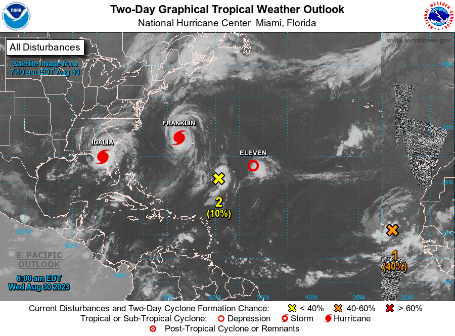
What's wild is that even though we're currently in an El Nino episode, the
Atlantic Hurricane season is already up to the "I" named storm. (I remember when
my hair used to be wild, too. Yes, you can shed a tear). Ya see, El Ninos
inhibit tropical storm formations in the Atlantic by increasing shear in
the atmosphere above--wind shear being deadly to hurricanes and all. Also a bit
more atmospheric stability. But the oceans are so warm, record levels even, that
the Atlantic Hurricane season has busted right through those impediments, and
also the reason these storms are intensifying so rapidly. The tropical systems
are a response to those oceanic temperature anomalies, dutifully transporting
the oceans heat to the poles.
And there ends your drunk thermodynamics lesson. No, I don't drink (although
I've been known to throw down a chocolate milk or two and go looking for
trouble), but all written above is probably a good example of if I did.
"Of if"??? Okay, that shows more insanity than drunkenness.
BACK TO THE WEATHER!
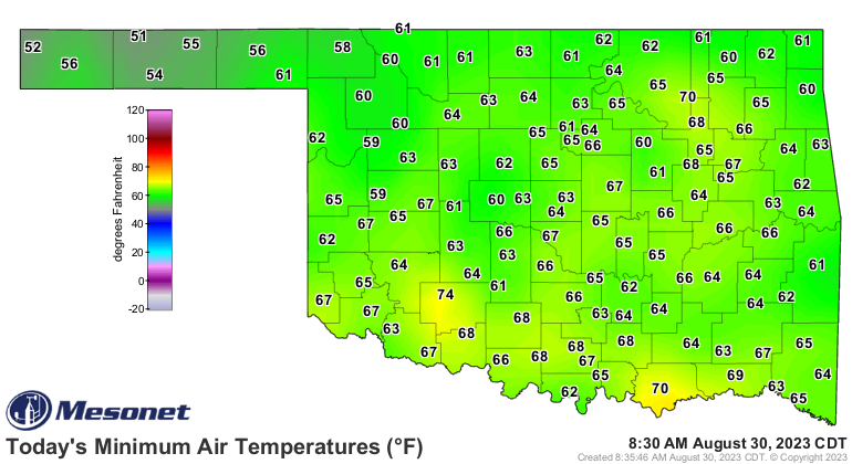
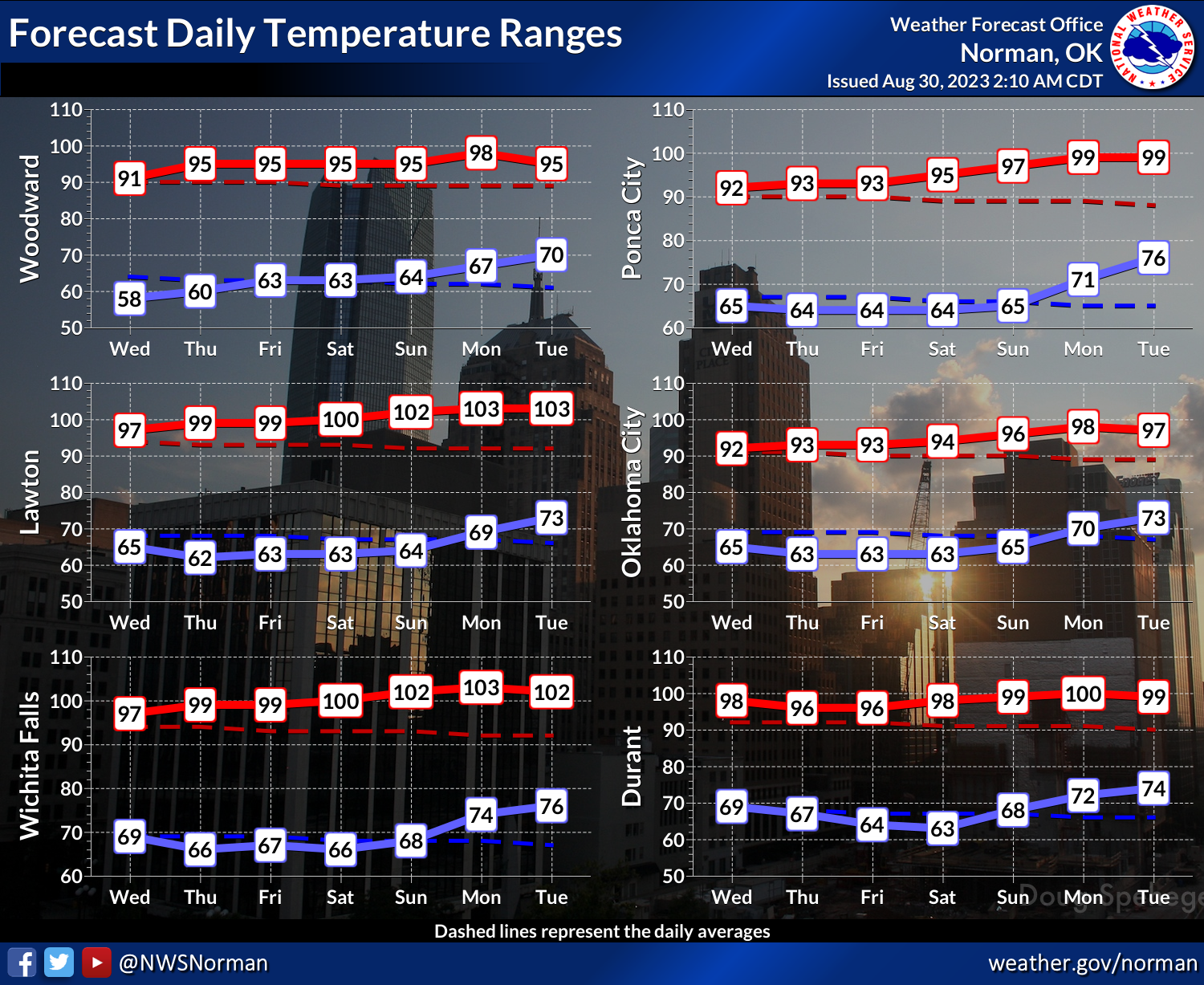
Today was the last "good" day, if that description for you comes with no
triple-digits in the state, and 50s and 60s for lows.
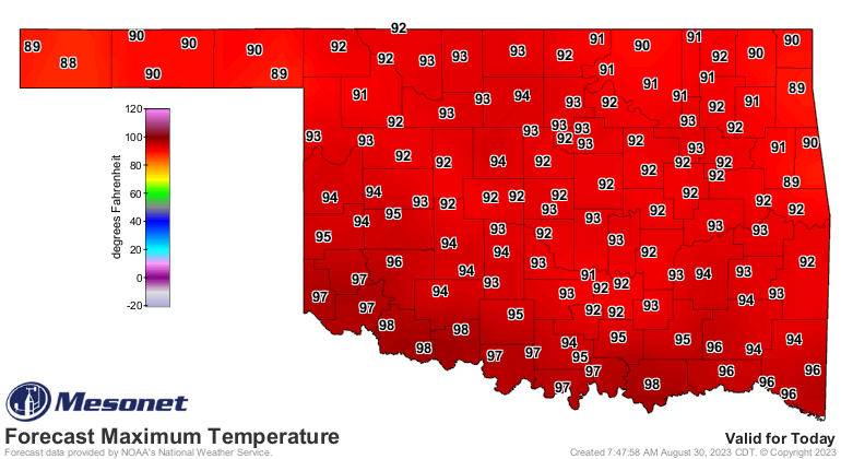
Not everybody will see 100s, of course, but they'll be back tomorrow and for
the foreseeable future with very little in the way of rain chances.
Sometimes boring can be preferable to exciting when dealing with weather, BUT
rain can be boring too.
Gary McManus
State Climatologist
Oklahoma Mesonet
Oklahoma Climatological Survey
gmcmanus@mesonet.org
August 30 in Mesonet History
| Record | Value | Station | Year |
|---|---|---|---|
| Maximum Temperature | 112°F | ALTU | 2011 |
| Minimum Temperature | 49°F | KENT | 2017 |
| Maximum Rainfall | 7.93 inches | MEDF | 2003 |
Mesonet records begin in 1994.
Search by Date
If you're a bit off, don't worry, because just like horseshoes, “almost” counts on the Ticker website!