Ticker for July 30, 2012
MESONET TICKER ... MESONET TICKER ... MESONET TICKER ... MESONET TICKER ...
July 30, 2012 July 30, 2012 July 30, 2012 July 30, 2012
An unfair comparison
Janet Jackson asked "What have you done for me lately?" LL Cool J said "Don't
call it a comeback." Slim Whitman warbled "I remember you-ooh." Now that we've
taken as stroll through my all-time favorite hits (eclectic, ain't I?), let's
talk memories ... especially those that we'd just as soon forget.
As the state continues to burn, figuratively AND literally, it's obvious that this
July is getting short-changed thanks to 2012's monster version. Now that might be
unfair (Cry me a river, July. No, really, as soon as possible!), but it's certainly
understandable. Let's take a sneak-peek at July thus far, courtesy of the Oklahoma
Mesonet. Remember, we still have two days of statistics left to go, from possibly
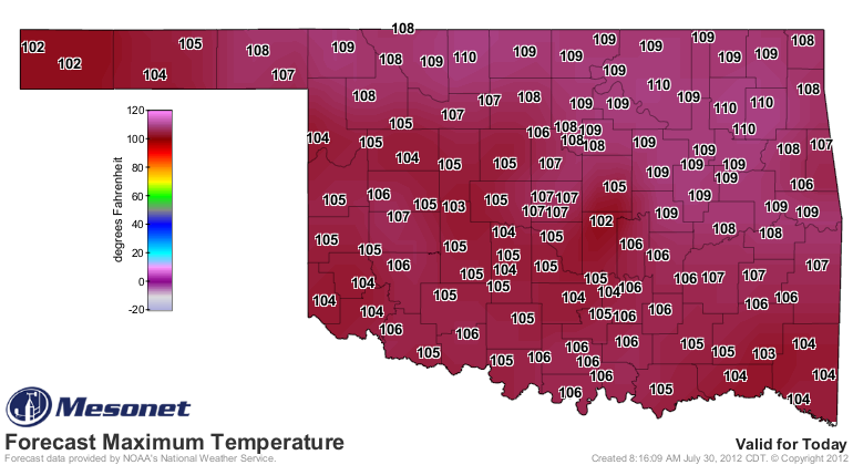
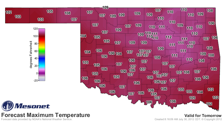
the two hottest days of the year so far (check out the forecast high temperatures
for the last two days in July).
So we can't write July's epitaph just yet (might need an epithet instead), but one
thing is becoming increasingly clear: this July is going to be a monster in the
ranks of warmest in state history.
Through yesterday, allowing for those ridiculous high temperatures to be included
the statewide average temperature according to the Oklahoma Mesonet was 85.5
degrees. HA! That's puny compared to last year's 89.3 degrees, right? Well, yes.
But last July was THE HOTTEST MONTH FOR ANY STATE since records began in 1895.
A tired statistic by now, but out of 67,000+ possible months to compare it with,
Oklahoma's July 2011 tops them all (on the way to the warmest summer on record for
any state as well). If we did finish at 85.5 (likely will go up several tenths of
a degree), that is still good for ninth warmest July on record in Oklahoma. Anytime
you are top-10 in heat for a summer month, or for cold in a winter month, it will
end up being highly significant, and usually bad things are happening. Here are the
top-10 warmest Julys based upon statewide average maximum and minimum temperatures.
These records date back to 1895.
-****-
2011 89.3
1954 88.1
1980 87.4
1934 87.3
1998 85.9
1936 85.8
2001 85.7
1978 85.6
1901 85.3
1964 84.7
-***-
Please note that these are finalized statewide averages from NCDC, and they are the
"official" record. The Mesonet numbers are much quicker, of course, since we are a
real-time network. And more than half of our stations are part of NCDC's final
numbers, so we're usually a pretty fair estimate of what the official numbers will
end up looking like.
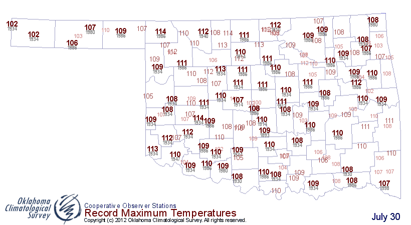
For those playing along at home wondering about records today, here are the numbers
to beat from across the state. The record high for the day statewide is 116 degrees
from Chickasha back in 1910. Let's hope we don't challenge that one.
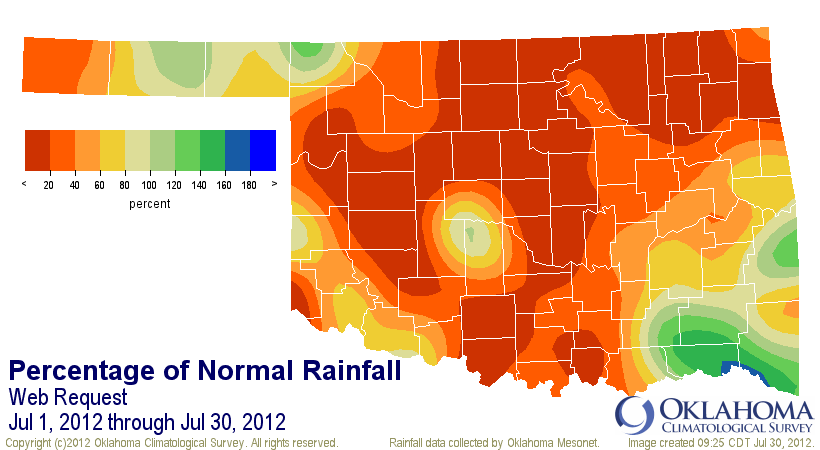
Precipitation-wise, we're going to end up being somewhere in the top-20 probably,
but that is deceiving since MOST Of the state has been dry as a bone. The
statewide average through this morning was 1.11 inches, 1.54 inches below normal
and the 15th driest since 1921. Those statistics will expand back to 1895 when
we get to the end of the month. For Spencer, Waurika and Marshall, it has been THE
driest July on record with 0.0 in the gauge. That's good enough to get you put on
double-secret probation in some places! Norman and Hollis show up as 0.0 but they
actually received 0.02 inches and 0.03 inches, respectively.
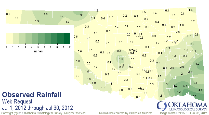
It has now been 53 days since Norman or Watonga received at least a tenth of an
inch of rain in a calendar day. That dearth spreads as you up the ante to a quarter
of an inch.
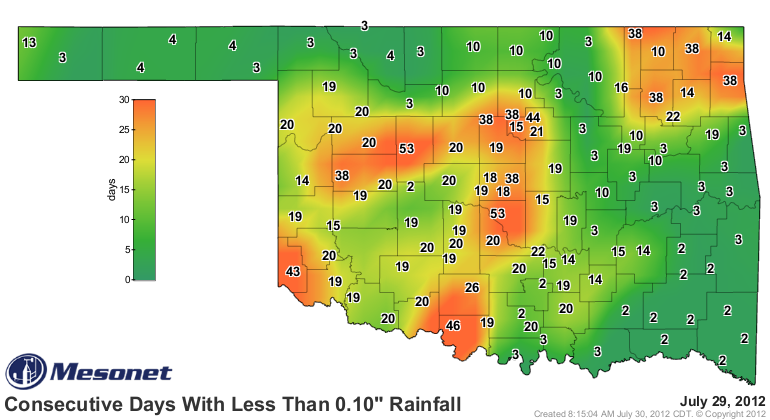
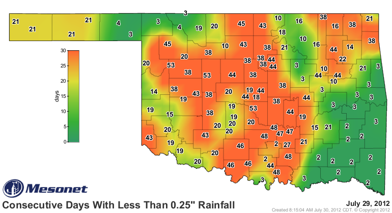
There doesn't look to be any appreciable rainfall in the state anytime soon.
Nothing close to a drought-buster showing up just yet, but August is a whole new
month with all new possibilities.
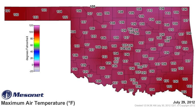
By the way, July 29 was the warmest day of the year with a statewide average
temperature of 91.1 degrees. That would only be the 16th hottest day last summer,
though.
Dang, even I'm doing it! Let's give Mother Nature her due for this July, lest
she hold a grudge. I don't even think she's over that whole "butter/margarine"
switch-a-roo yet!
Gary McManus
Associate State Climatologist
Oklahoma Climatological Survey
(405) 325-2253
gmcmanus@mesonet.org
July 30 in Mesonet History
| Record | Value | Station | Year |
|---|---|---|---|
| Maximum Temperature | 111°F | CHER | 2012 |
| Minimum Temperature | 54°F | BOIS | 2004 |
| Maximum Rainfall | 4.89 inches | SPEN | 2014 |
Mesonet records begin in 1994.
Search by Date
If you're a bit off, don't worry, because just like horseshoes, “almost” counts on the Ticker website!