Ticker for August 27, 2012
MESONET TICKER ... MESONET TICKER ... MESONET TICKER ... MESONET TICKER ...
August 27, 2012 August 27, 2012 August 27, 2012 August 27, 2012
Very nice rains ... could there be more?
Yes, just as I (okay, the NWS folks might have had something to do with it)
predicted, the state did see some very beneficial rainfall over the weekend. It
might have taken a bit longer to arrive for most, but arrive it did. Here is
the Mesonet/RFC map for the event. We'll go back five days to try and capture it
all.
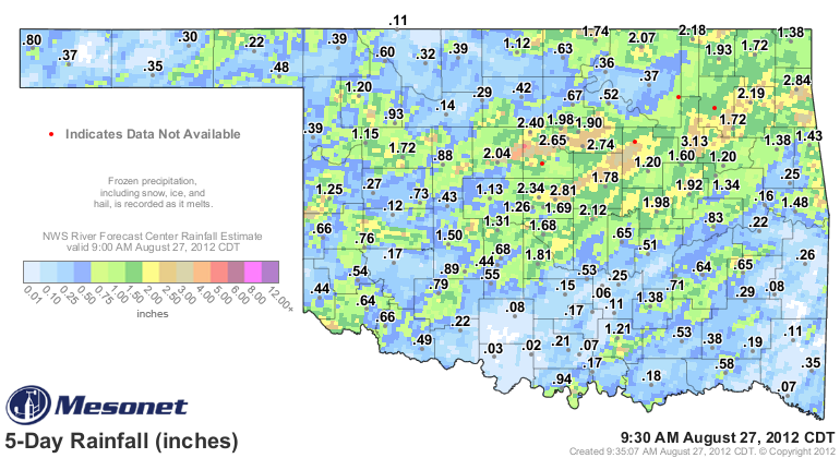
There were several great tracks of rain as storms trained over the same area for
a few hours. It looks like Kingfisher through Payne County got the best rains, with
2-4 inches apparent from the Mesonet gauges and also the radar estimates. That
area then extends up into the northeastern corner of the state, where 1-3 inches
appears common. It was a good general rain of about an inch for most of the area
otherwise. Those left out are obvious in the light blue.
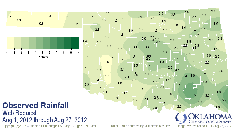
The event brings the August statewide average up to 2.25 inches, which is only
0.15 inches below normal for the Aug. 1-27 period. The Panhandle and much of
western and northern Oklahoma are still down for the month ... some parts
exceedingly so.
The question now is, how much did it help the drought? We have to be cautious
here and not rely upon rainfall statistics alone. The forecast for the state
so far is for a hot and dry week ahead. Given that it is still August and the
underlying drought conditions, that might make short work of any improvements
we've seen. We'll be taking a look at all the factors and see how well they
have responded, basically a short-term vs. long-term balancing act.
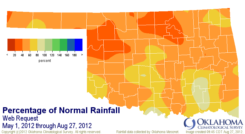
Take a look at where we are now since May 1. This is what will give you pause
while considering where to adjust the Drought Monitor map. Some of the areas
that saw nice rains this week had not seen much at all in the previous four
months. There's still enough red and orange in those maps to supply a pretty
good week of bedlam!
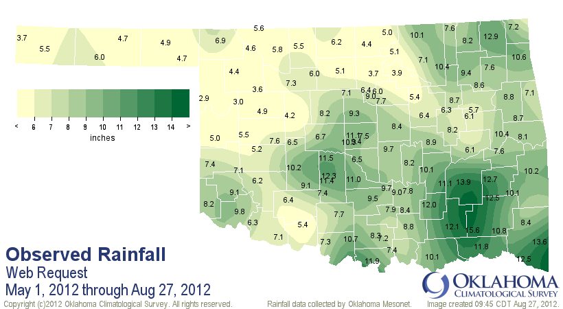
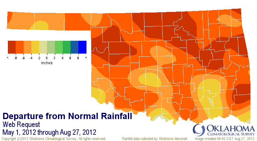
In fact, the May 1-Aug. 27 period is still the second driest such period on
record for the state going back to 1921.
-****-
Region Avg. Tot Dep. Pct. Rank Since 1921
Panhandle 4.91" -6.07" 45% 1st driest
N. Central 5.18" -9.25" 36% 1st driest
Northeast 8.20" -7.76" 51% 3rd driest
W. Central 5.55" -7.66" 42% 2nd driest
Central 8.57" -6.29" 58% 5th driest
E. Central 8.65" -7.42" 54% 2nd driest
Southwest 7.68" -5.78" 57% 6th driest
S. Central 9.18" -5.41" 63% 11th driest
Southeast 11.83" -5.21" 69% 15th driest
Statewide 7.74" -6.77" 53% 2nd driest
-***-
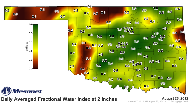
A few of the impacts would/should have already begun to improve. The soil
moisture in the upper 10 inches has responded quite well. Check out at all
the green at 2 inches!
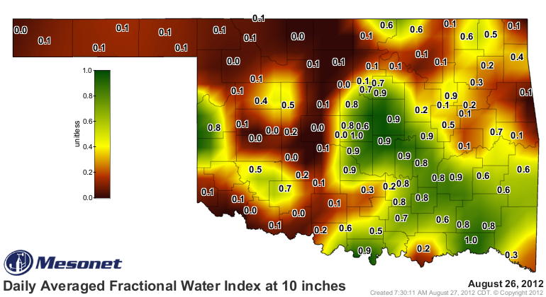
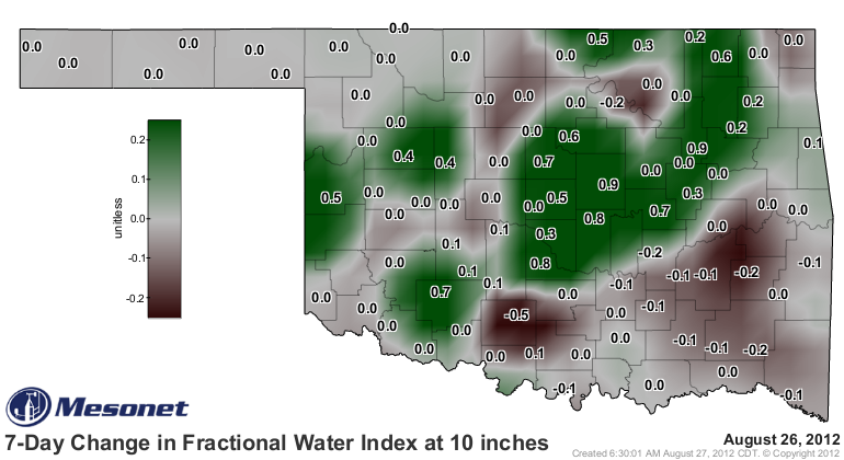
Still a lot of brown at 10 inches, but some really nice improvements as evidenced
by the 7-day change map.
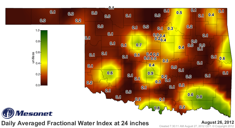
The trouble, again, is that the recharge hasn't made it down to the lower levels
just yet. Check out the map at 24 inches.
But, that moistening at 10 inches is a start. Reinforcing rainfalls will add
more green to that map at 24 inches. When might those rains come? Maybe from
our erstwhile friend meandering around in the tropics? Each successive landfall
forecast for Tropical Storm Isaac (expected to become Hurricane Isaac soon) has
pushed it farther to the west. The latest has New Orleans directly in the
path, and after that a trip up in our direction.
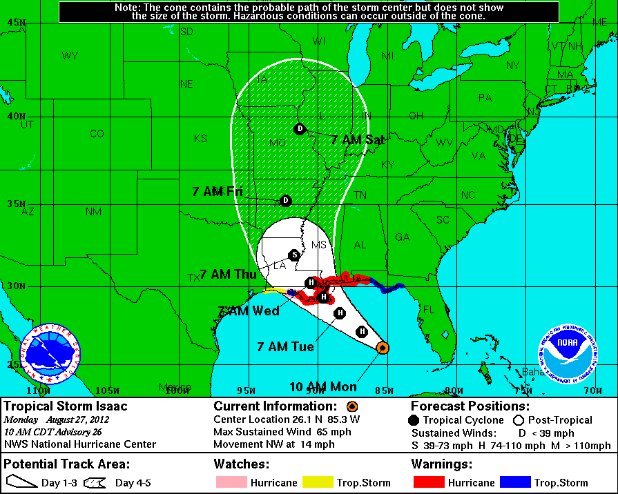
So eastern Oklahoma is in the probability cone from the National Hurricane
Center. Some of the individual models have the remnants coming right up over
Oklahoma!
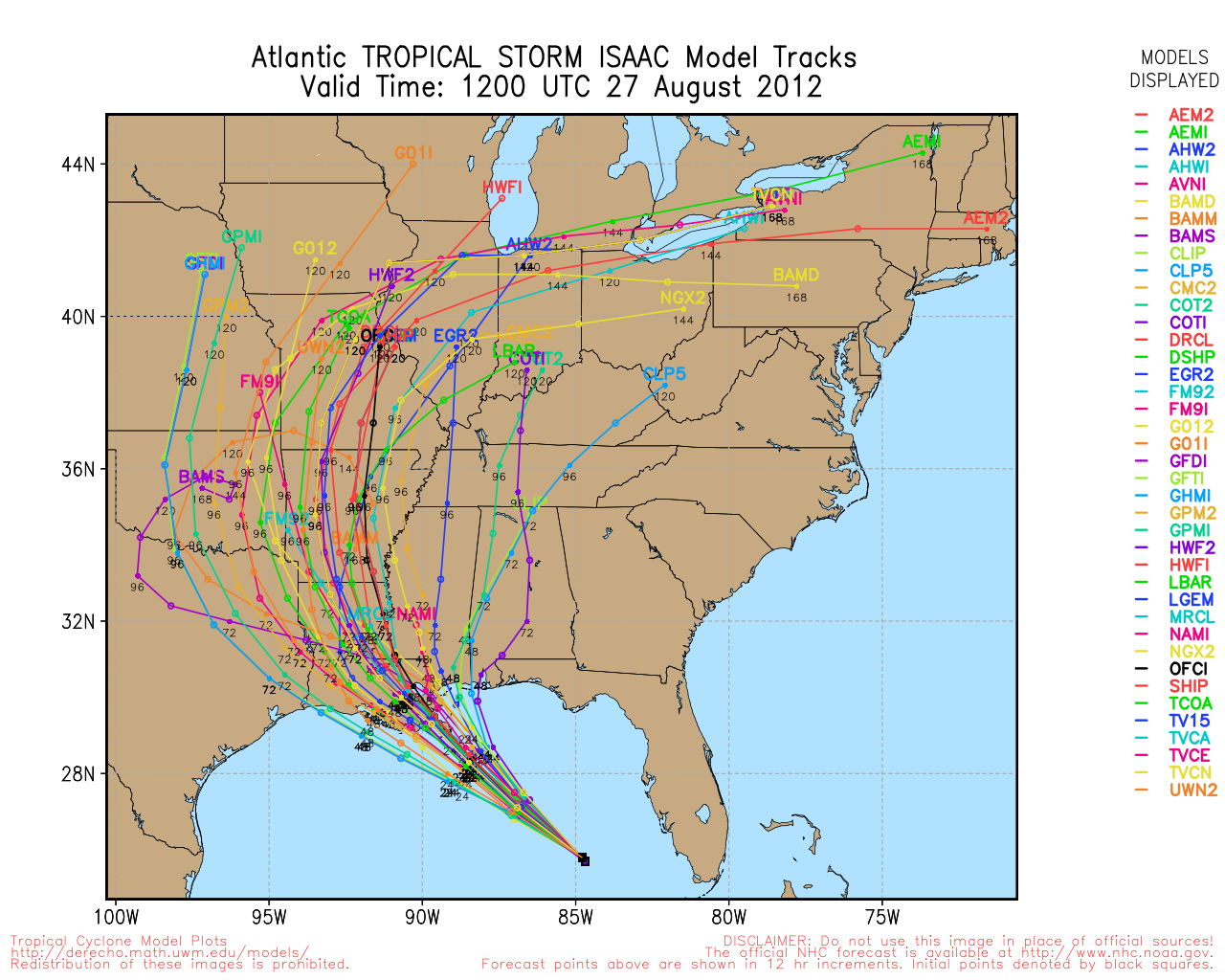
But that's the trick, you don't need the center of circulation to travel over
you to get rainfall. These circulations are extremely large, and they carry
lots of moisture with them.
Only time will tell what Isaac plans to do with the weak steering winds about.
However, another reinforcing rainfall instead of the hot, dry week ahead would
do us nicely!
Gary McManus
Associate State Climatologist
Oklahoma Climatological Survey
(405) 325-2253
gmcmanus@mesonet.org
August 27 in Mesonet History
| Record | Value | Station | Year |
|---|---|---|---|
| Maximum Temperature | 109°F | GRA2 | 2011 |
| Minimum Temperature | 48°F | SEIL | 2010 |
| Maximum Rainfall | 3.95 inches | CLOU | 1996 |
Mesonet records begin in 1994.
Search by Date
If you're a bit off, don't worry, because just like horseshoes, “almost” counts on the Ticker website!