Ticker for July 27, 2023
MESONET TICKER ... MESONET TICKER ... MESONET TICKER ... MESONET TICKER ...
July 27, 2023 July 27, 2023 July 27, 2023 July 27, 2023
How green is your Panhandle?
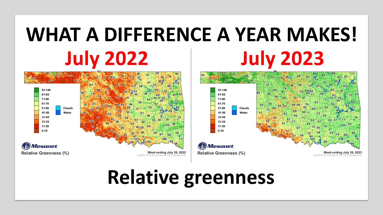
Now when's the last time far NW OK and the Panhandle has been that green?
1986, maybe?
Heck if I know, but I know it hasn't been this green for awhile after dealing with
almost continuous drought out that way for the last decade-plus. Looking at a
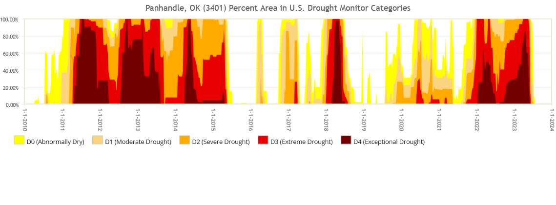
time series of drought in the Panhandle Climate Division (CD1 for those asking...
and for those not asking because you involuntarily finished reading this), time
spent in drought for that region far outpaces times not in drought. In fact, the
time spent in serious drought (is there any other kind?) is evident with those
darker reds going back to 2010 or so, which encompasses the horrific 2010-15
drought.
At any rate, I don't mean to just focus on the Panhandle. But I really do since
it's the greatest place in the universe...but I digress. The rest of the state
is mostly doing great as well, such a pleasant change from recent memory of
flash droughts, unbearable temperatures, foot fungus...wait, that slipped in
there by accident. NO, not me! Some other State Climatologist. Texas! Yeah, he
has foot fungus. Remind me to erase this later.
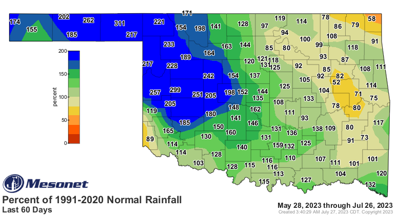
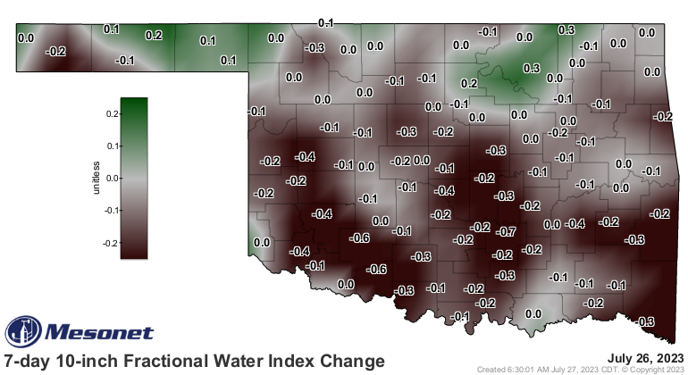
But looking at those two maps, we can also see that far SW OK hasn't really
enjoyed as much of that greening as the rest of the state. And that's one of
the areas that remains entrenched, along with north central OK, in pretty
serious drought conditions.

Hey, if you think being entrenched is bad, wait until you're ensconced. And
we ALL know just how painful that can be.
We've built this greenness (we've built this greenness on rock and roll...worst
Starship song EVER) on the backs of the near-historic rainfall over parts of the
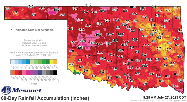
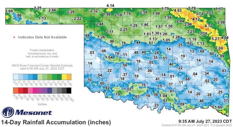
state through the past few months. Check out the 60-day rainfall showing that
the Panhandle and west central climate divisions have had their wettest such
periods in at least the last 100 years!
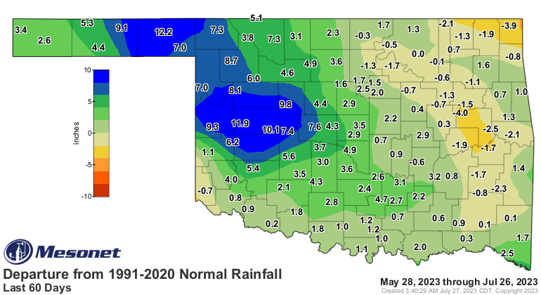
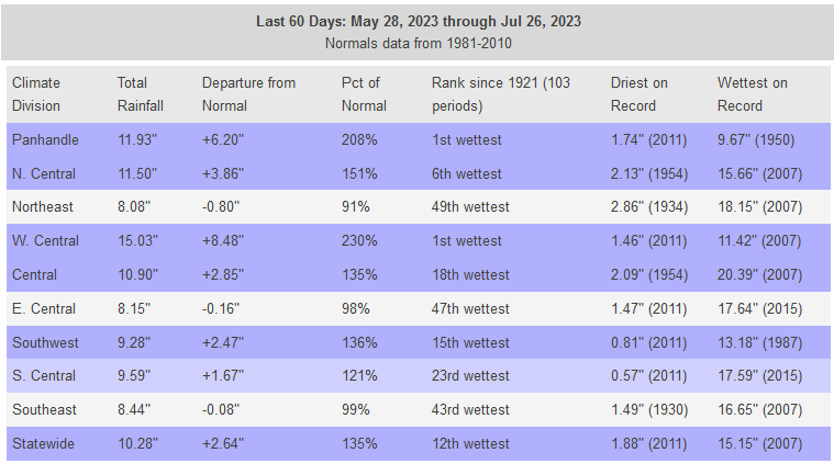
In fact, part 2, take a look at those 60-day totals vs. their 1991-2020 normal
60-day and ANNUAL average totals.

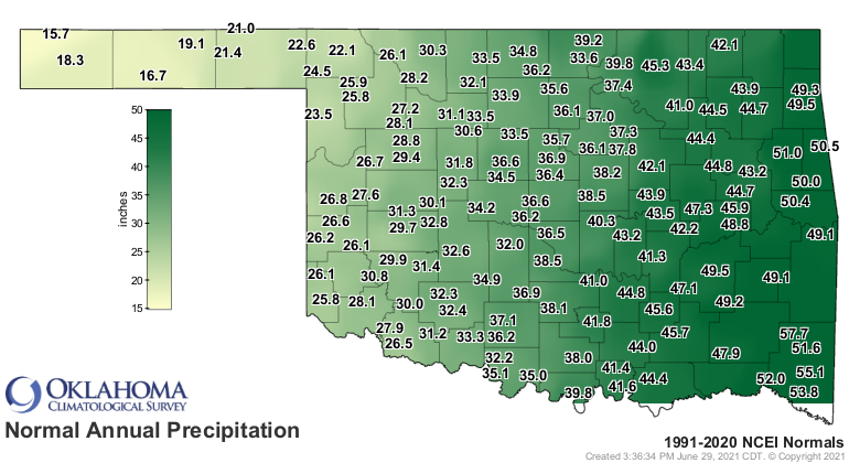
Wow! So some of those sites have seen nearly a year's worth of precip in the
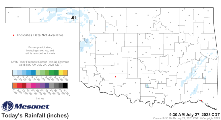
last 2 months. Speaking of rainfall, heck it's raining right now for crying out
loud! Well, sorta. Not much is reaching the ground, at least.
But here's the deal...and I don't mean to be alarming here (but I had to look
in the mirror this morning so why should I be the only one frightened??), but
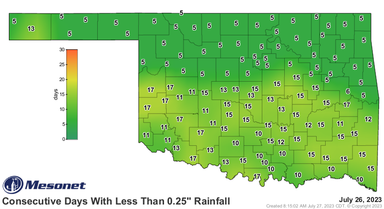
we are sorta in prime flash drought territory, especially south of I-40. The
rains have shut off pretty abruptly and we are now seeing that stretch without
at least a quarter-inch of rain approaching 3 weeks in some areas. The sun
is out and relentless, and the heat--even for summer in OK--is well above normal
and blistering our vegetation.
And the heat and lack of rain is expected to stretch at least another 7-10 days.
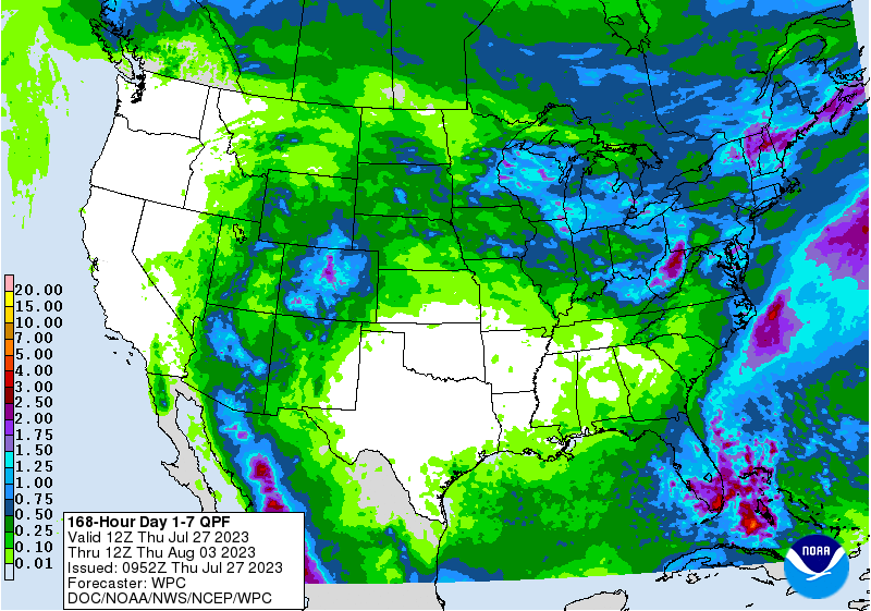
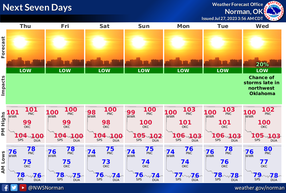
So another week to 10 days of loss of soil moisture, stress on plants (and us
animals), and possible flash drought.
Now we're still seeing some relief possible maybe at the end of next week? That's
approaching fantasy-cast territory, so I hesitate to sound too confident of that.
Until then...hot, dry, and windy weather will continue.
Gary McManus
State Climatologist
Oklahoma Mesonet
Oklahoma Climatological Survey
gmcmanus@Mesonet.org
July 27 in Mesonet History
| Record | Value | Station | Year |
|---|---|---|---|
| Maximum Temperature | 112°F | ALV2 | 2011 |
| Minimum Temperature | 49°F | KENT | 2005 |
| Maximum Rainfall | 4.96 inches | YUKO | 2020 |
Mesonet records begin in 1994.
Search by Date
If you're a bit off, don't worry, because just like horseshoes, “almost” counts on the Ticker website!