Ticker for July 19, 2012
MESONET TICKER ... MESONET TICKER ... MESONET TICKER ... MESONET TICKER ...
July 19, 2012 July 19, 2012 July 19, 2012 July 19, 2012
Heat and drought surge once again in Oklahoma
The drought plaguing much of the interior United States continues to stretch its
tendrils into Oklahoma. Some experts claim the country?s current drought is the
worst in a generation and possibly the largest since the great droughts of the
1930s and 1950s. In Oklahoma, significant heat along with mounting rainfall
deficits have allowed drought to flourish once again. This morning?s release of
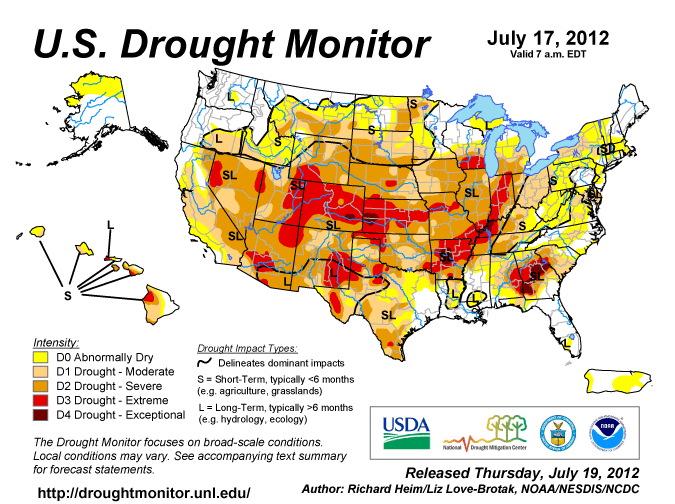
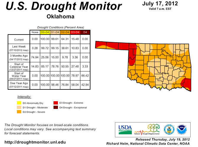
the U.S. Drought Monitor report indicates severe to extreme drought had crept
into the state from both the east and the west, with 64 percent of Oklahoma now
portrayed in at least severe drought. That is the highest such level since Nov.
22, 2011, when the drought had just begun to diminish following its zenith in
October. Approximately 15 percent of the state is considered in the extreme
drought category, the highest percentage since early March when the drought
appeared headed towards extinction. The Drought Monitor?s intensity scale slides
from moderate-severe-extreme-exceptional, with exceptional being the worst
category.
Drought Monitor: National
Drought Monitor: Oklahoma
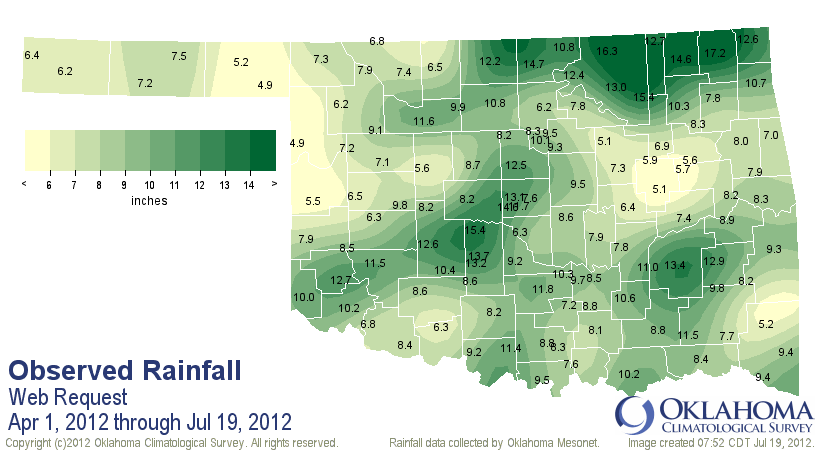
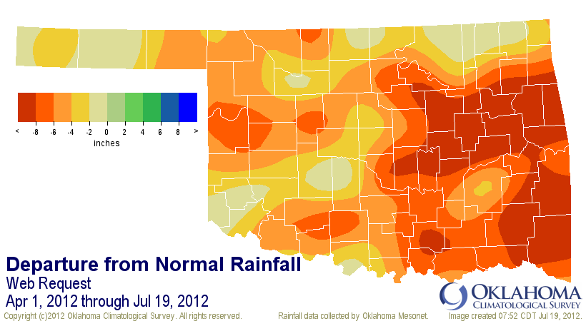
Unfortunately, the drought-quenching rains that extended through winter into
March disappeared as the state?s primary rainy season approached. According to
data from the Oklahoma Mesonet, the statewide average rainfall deficit from
April 1 through July 18 grew to more than 5 inches. The statewide average total
over that period was 8.95 inches, the fourth driest on record dating back to at
least 1921. Parts of eastern Oklahoma are up to a foot below normal, while the
northwestern corner of the state is running a comparable 6-8 inch deficit. The
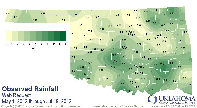
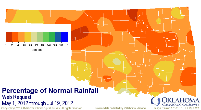
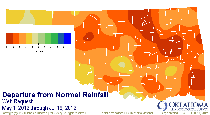
rainfall deficits steepened deeper into the rainy season. Since May 1, the
statewide average rainfall total stood at 5.14 inches, nearly 6 inches below
normal and the second driest May 1-July 18 dating back to at least 1921. For
north central Oklahoma, it was the driest such period since 1921 with an
average total of 3.21 inches, 7.4 inches below normal. Southwestern Oklahoma
fared the best since May 1 with an average total of 5.95 inches, still a
deficit of 4.4 inches, for a dismal ranking of 10th driest since 1921.
April 1-July 19 Mesonet rainfall maps
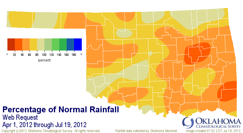
May 1-July 19 Mesonet rainfall maps
The drought impacts continue to mount. There are 29 county burn bans in effect
as the vegetation that was allowed to thrive during the warm and wet early
spring dries out, becoming fuel for wildfires. Reports of cattle sell-offs due
to diminishing stock ponds and a lack of hay or pasture are becoming more
numerous, and warm-season crop conditions show further deterioration. The USDA
rated 91 percent of the state?s topsoils as being either short or very short
of moisture, with a similar rating of 89 percent for the subsoils. State
reservoirs have seen a steepening decline through the dry weather. Lake
Altus-Lugert, an important irrigation lake for the cotton crop in the
southwest, is down to 21 percent of its conservation pool. A part of Oklahoma
City?s water supply chain upstream to the northwest, Canton Lake has faced
steady declines and is now at 50% of its conservation pool. Several of the
state?s largest reservoirs are between 80-85 percent of their conservation
pools, such as Skiatook at 82 percent and Eufaula at 85 percent.
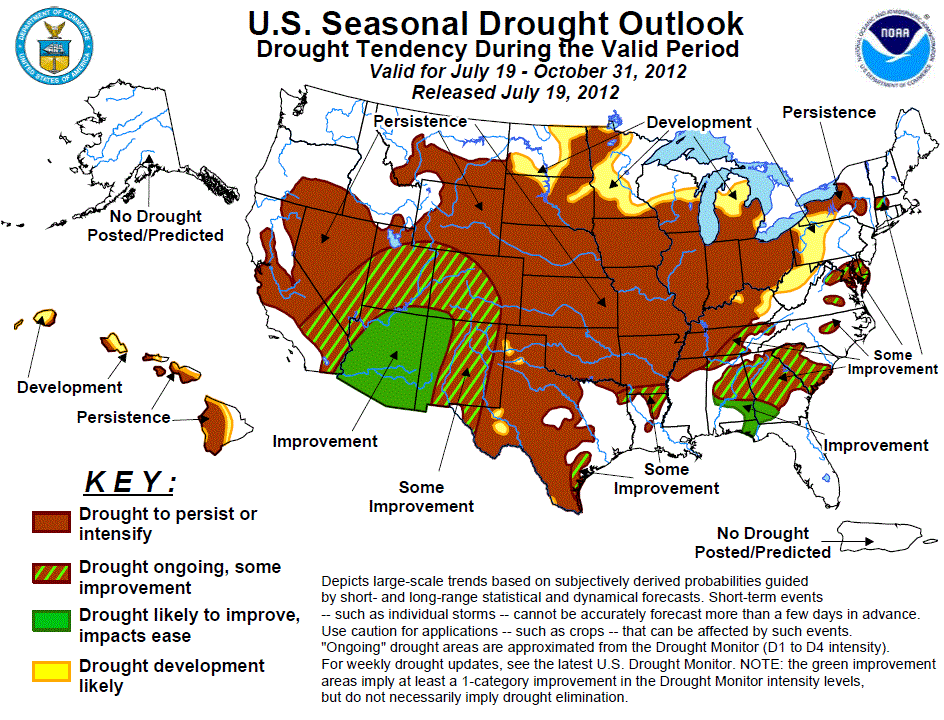
The outlook for relief is a bit bleak, at least in the short term. The Seasonal
Drought Outlook released Thursday morning by the Climate Prediction Center
calls for drought to persist or intensify over much of the United States,
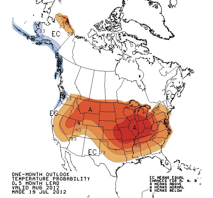
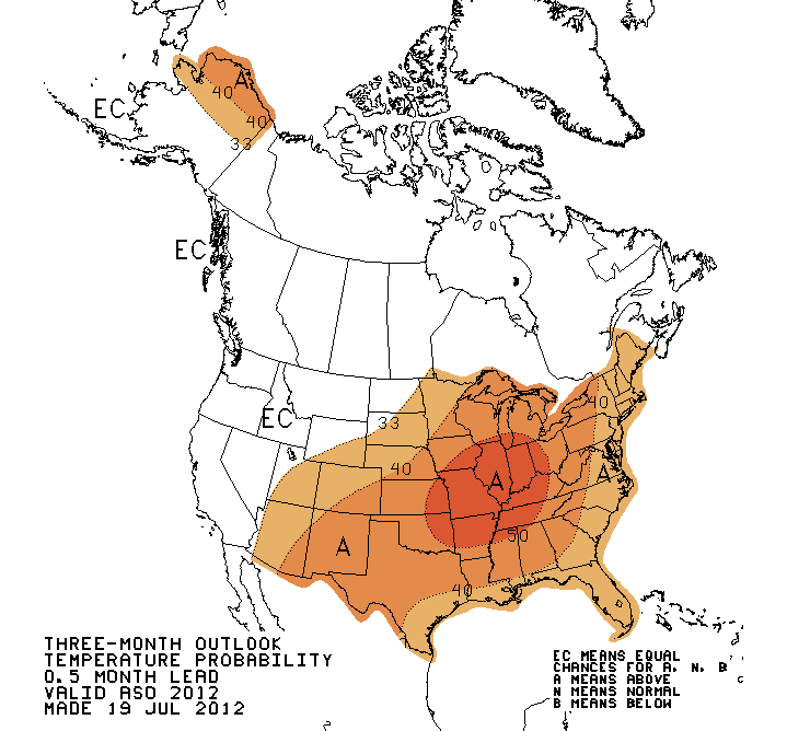
including Oklahoma, through at least the next couple of weeks. All indicators
continue to favor above normal temperatures through August and the August-
October period. Further heat would allow for continued drought intensification
should rainfall remain scarce. Widespread triple-digit temperatures have
returned to the state in recent days. The average temperature for July thus
far is 2.5 degrees above normal, well on its way to becoming the 23rd month
out of the last 28 to finish warmer than normal. Oklahoma continues on a
possible course towards its warmest year on record, dating back to 1895. The
statewide average January-June temperature finished at a record 60 degrees, 5
degrees above normal and besting 2006?s 58.9 degrees. The mark for the state?s
warmest year on record remains 1954?s 62.8 degrees.
CPC Seasonal Drought Outlook
CPC Temperature Outlooks
Gary McManus
Associate State Climatologist
Oklahoma Climatological Survey
(405) 325-2253
gmcmanus@mesonet.org
July 19 in Mesonet History
| Record | Value | Station | Year |
|---|---|---|---|
| Maximum Temperature | 115°F | MANG | 2022 |
| Minimum Temperature | 53°F | COOK | 2014 |
| Maximum Rainfall | 3.82 inches | BREC | 1997 |
Mesonet records begin in 1994.
Search by Date
If you're a bit off, don't worry, because just like horseshoes, “almost” counts on the Ticker website!