Ticker for July 12, 2012
MESONET TICKER ... MESONET TICKER ... MESONET TICKER ... MESONET TICKER ...
July 12, 2012 July 12, 2012 July 12, 2012 July 12, 2012
Drought encompasses entire state for first time since last November
Fueled by the Oklahoma's sixth driest April 1-July 12th period since 1921, and
despite recent localized heavy downpours, drought now encompasses virtually the
entire state for the first time since Nov. 15, 2011.
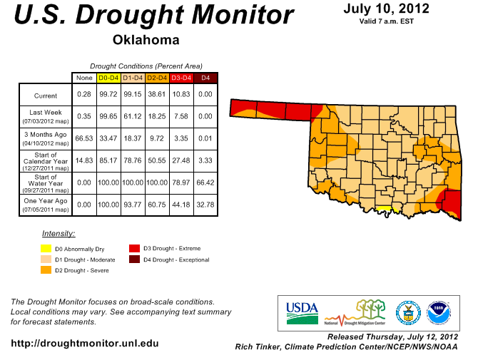
Nearly 39% of the state is now labeled in severe-extreme drought, although
the extreme portion is only 11%. The severe-extreme percentage is up 20% from
last week's map. No part of the state has made it back to exceptional drought,
the U.S. Drought Monitor's worst designation. Exceptional drought is beginning
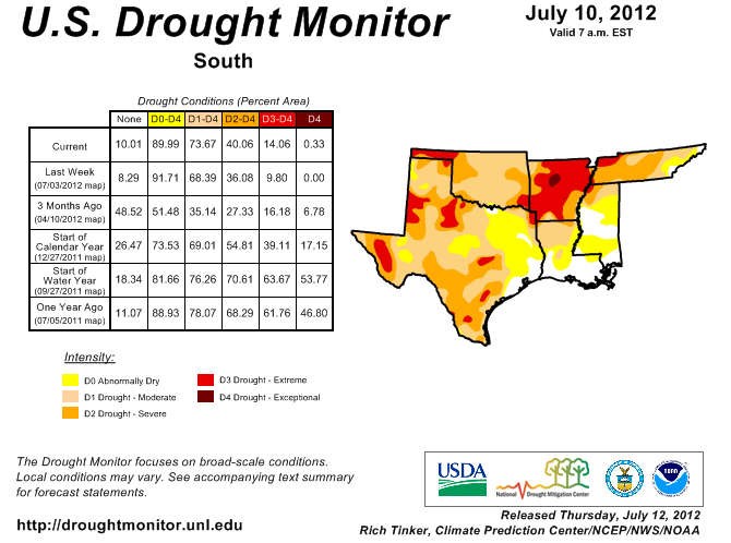
to build in central Arkansas, however, and similar conditions are creeping
towards eastern Oklahoma.
At this time last year, 33% of Oklahoma was suffering from exceptional drought.
Further intensification occurred in southeastern Oklahoma, where severe drought
is now labeled extreme. Moderate drought worsened to severe drought from
northwestern through west central Oklahoma. Several indicators led to the
intensification, from steadily dwindling lake levels detailed a couple of days
ago to a rapid decline in soil moisture and rangeland/pasture conditions. The
main factor is rainfall, of course. And that is something that has been in
short supply right through Oklahoma's primary rainy season of April through
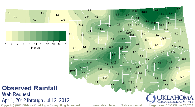
mid-June, bleeding right into the heart of summer. According to data from the
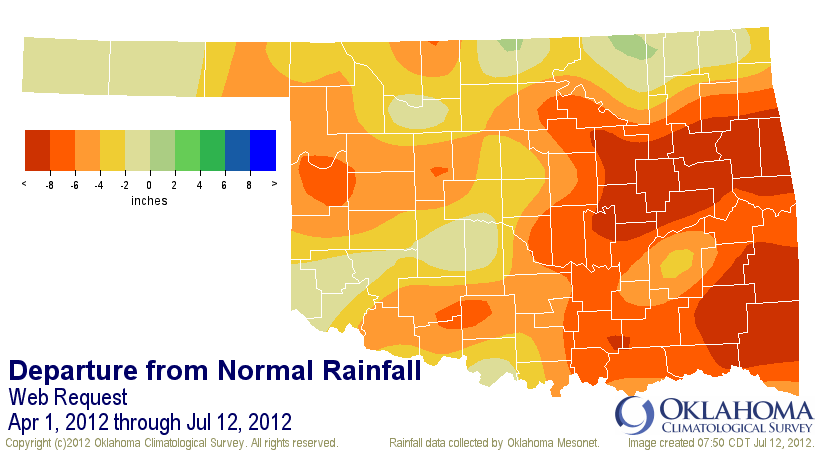
Oklahoma Mesonet, the statewide average rainfall total since April 1 is 8.83",
a deficit of 4.93" or 64% of normal. Southeastern and east central Oklahoma are
sporting deficits of 8.34" and 8.13" and rankings of second driest and third
driest on record, respectively.
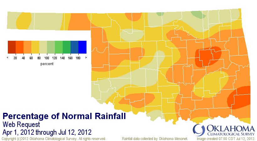
April 1-July 12 Mesonet rainfall maps
-****-
April 1-July 12 Mesonet climate division rainfall statistics
Climate Division Total Depart. Pct. Norm. Rank Since 1921
OK-1: Panhandle 6.11" -2.99" 67% 15th driest
OK-2: N. Central 9.23" -3.63" 72% 17th driest
OK-3: Northeast 11.30" -4.06" 74% 11th driest
OK-4: W. Central 7.08" -5.00" 59% 6th driest
OK-5: Central 9.66" -4.79" 67% 10th driest
OK-6: E. Central 7.90" -8.13" 49% 3rd driest
OK-7: Southwest 9.59" -2.86" 77% 25th driest
OK-8: S. Central 9.10" -5.41" 63% 8th driest
OK-9: Southeast 8.60" -8.34" 51% 2nd driest
Oklahoma Statewide 8.83" -4.93" 64% 6th driest
-***-
There are a few broad areas in those maps that show above normal rainfall, such
as northern Oklahoma where heavy rains fell in April. The problem is that is
really the last of the widespread rains in the midst of suddenly hot
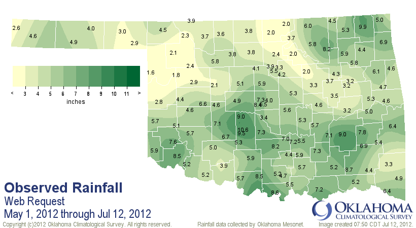
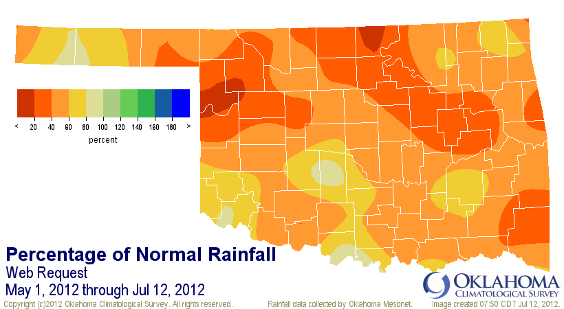
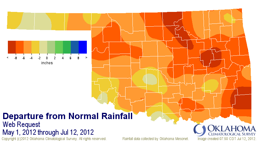
moisture-sapping summer heat. Here are those same rainfall maps since May 1.
The statewide average since May 1 is 5.01", 5.42" below normal and the third
driest such period since 1921.
So what we're dealing with is a battle and/or combination of short- and long-
term dryness. In places that had nice rains in April, like north central
Oklahoma, the intervening period since has been exceedingly dry. And for those
places that received recent rains, long-term concerns overwhelm those benefits.
Add to that the cutoff point of Tuesday morning for any precipitation to be
considered by the Drought Monitor and you get the most recent map. The localized
areas that received nice rains have seen relief, but those small areas are
difficult to portray on the Drought Monitor map, which is not meant to display
down to a sub-county scale.
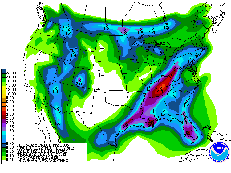
Spotty showers are in the forecast for the next few days, but those are
expected to bring only localized benefits. The latest 5-day rainfall forecast
by the HPC is pretty bleak.
Past that, the CPC is calling for increased chances for normal rainfall
amounts and temperatures, but that is again part of the problem. Normal rainfall
amounts during the summer are not enough to overcome the consumptive demands of
humans and plants, and also evaporation due to heat, intense sunshine and wind.
The heat is reflected in the latest map of days at or above 100 degrees from
the Oklahoma Mesonet.
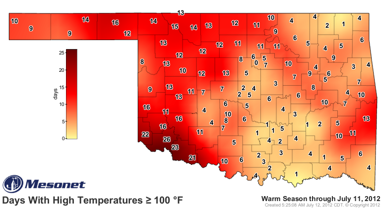
That map is still a far cry from last year at this time, with nearly 50 days
above 100 degrees in southwestern Oklahoma, and from 20-30 across much of
western Oklahoma.
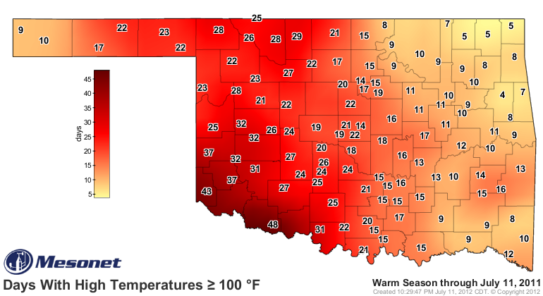
The 100s started much earlier last year with a more mature drought already in
place entering June. This year is well on its way to being the warmest on
record based for the state, but that is largely due to a lack of any type of
frigid air through winter into spring. The first six months of the year and
also the spring period were the warmest statewide since records began in 1895.
That accelerated vegetative growth and also evaporative demands much earlier
this year.
You can read about those other drought indicators from the past couple of
Tickers.
Pastures/Rangeland and Soils
http://ticker.mesonet.org/select.php?mo=07&da=12&yr=2012
Lake Levels
http://ticker.mesonet.org/select.php?mo=07&da=06&yr=2012
Again, the key is rainfall. More summer rains will bring a milder
summer while further drought will beget more heat. Summertime rains are
very difficult to predict, although most residents know what you "normally"
get during an Oklahoma summer, and widespread relief from the skies usually
isn't on the list.
But this is Oklahoma, land of normally not-normal weather. Forrest Gump's Mom
was a pretty smart lady.
Gary McManus
Associate State Climatologist
Oklahoma Climatological Survey
(405) 325-2253
gmcmanus@mesonet.org
July 12 in Mesonet History
| Record | Value | Station | Year |
|---|---|---|---|
| Maximum Temperature | 110°F | HOLL | 2001 |
| Minimum Temperature | 52°F | EVAX | 2021 |
| Maximum Rainfall | 4.44″ | OKMU | 1996 |
Mesonet records begin in 1994.
Search by Date
If you're a bit off, don't worry, because just like horseshoes, “almost” counts on the Ticker website!