Ticker for September 9, 2020
MESONET TICKER ... MESONET TICKER ... MESONET TICKER ... MESONET TICKER ...
September 9, 2020 September 9, 2020 September 9, 2020 September 9, 2020
Stupid winter
Oh, so a fella can't like "Road House" AND "Ghost?" How about "Dirty Dancing,"
too? If somebody can't be marveled at the incredible range and talent of one
Patrick Wayne Swayze, then we've truly lost all hope. Here's the deal, though...if
we're going to have an early blast of winter/fall/(still summer) (work those
seasons from west to east in your mind), then the least we could do is break some
all-time records. We have done that to some degree (get it?), but not the biggies.
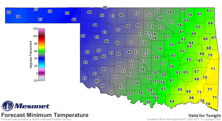
Lots of record lows shattered this morning.
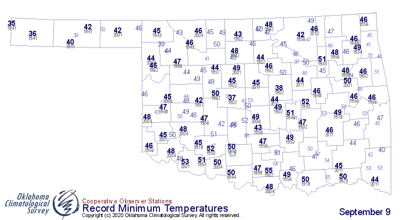
The earliest snow in state history will remain Sept. 17, 1971, at Kenton and
Boise City. The earliest freeze will remain Sept. 13, 1902, at Fort Reno. Cimarron
County really let me down last night, and after I've sung its praises for so long!
Oh, I can't really stay mad at Cimarron County...still the best place in Oklahoma,
save for a small gem in Harper County. No, not Laverne. Buffalo. Like I said,
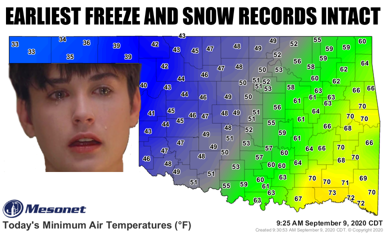
though, we did beat some records. The 33 degrees at Kenton and Boise City is the
lowest temperature ever recorded for this early in the season (if we now consider
the cool season to have started...now get ready for some more 100s). Previous
record was Kenton's 35 degrees from Sept. 4, 1961.
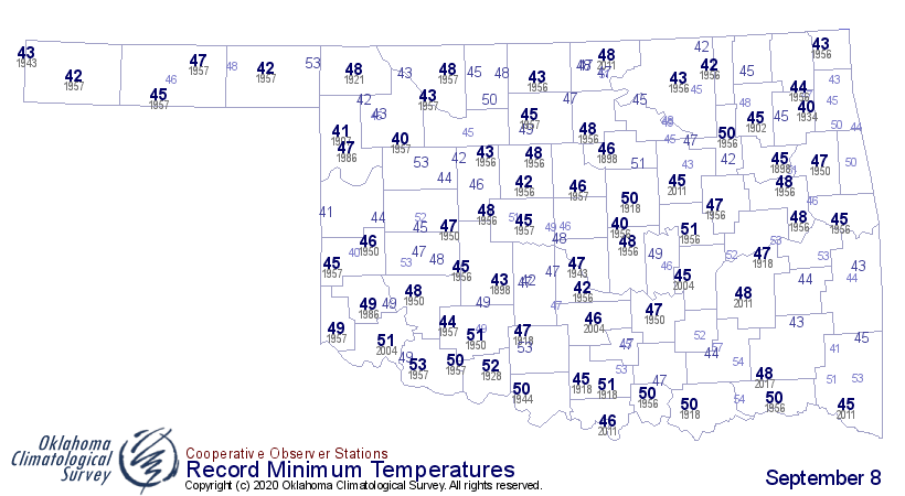
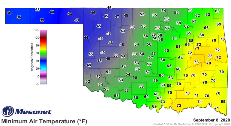
And we did beat some records for yesterday's minimum temperatures, which all came
right before midnight.
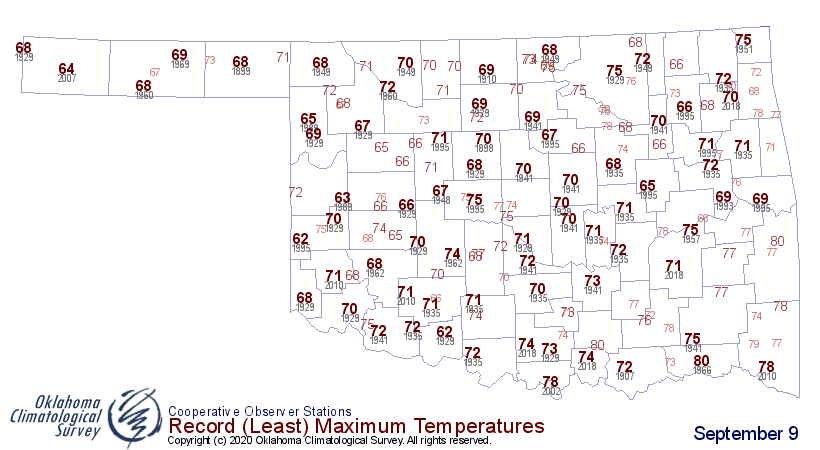
And we're definitely going to top many of today's record low maximum
temperatures.
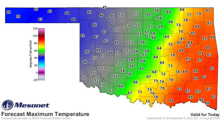
Wow! Hold on a second. Pardon me for thinking as I type this. I usually try to
avoid that. The lowest maximum temperature ever recorded on this date in state
history (and before statehood) is 62 degrees at Erick in 1995 and Walters in
1929. And the western Panhandle isn't supposed to get out of the 30s? HOLY
MACKEREL! That's a pretty momentous achievement. Wait a second...I'll be right
back as I go check something. Discuss amongst yourselves. Topic: Patrick Swayze's
performance in "Red Dawn" was possibly the greatest achievement on film since
Dr. J's role in "The Fish That Saved Pittsburgh."
Okay, back. That's the earliest we've seen a high in the state in the 30s by 19
days! The previous earliest date in the season to see a high in the 30s in state
history was 38 degrees at Guymon on Sept. 19, 1945. So we will wipe that record
off the map if that temperature forecast holds throughout the day.
Then we get tonight's lows plunging into the 30s out west again. The air mass
is probably modifying pretty quickly, so I'm not sure we have enough miracle
left to get below freezing to break that all-time earliest freeze record.
This cold snap is definitely historic in many ways. Most importantly, this is
the earliest in the season for me to say "I'm tired of this cold weather."
There, I said it.
Gary McManus
State Climatologist
Oklahoma Mesonet
Oklahoma Climatological Survey
(405) 325-2253
gmcmanus@mesonet.org
September 9 in Mesonet History
| Record | Value | Station | Year |
|---|---|---|---|
| Maximum Temperature | 100°F | TIPT | 2016 |
| Minimum Temperature | 33°F | KENT | 2020 |
| Maximum Rainfall | 8.09″ | SALL | 2010 |
Mesonet records begin in 1994.
Search by Date
If you're a bit off, don't worry, because just like horseshoes, “almost” counts on the Ticker website!