Ticker for August 8, 2012
MESONET TICKER ... MESONET TICKER ... MESONET TICKER ... MESONET TICKER ...
August 8, 2012 August 8, 2012 August 8, 2012 August 8, 2012
The state has acne
Don't bother with the Clearasil. This is actually a good thing. Pop-up showers
and storms gave some parts (here, and there, and also over there, around the
corner from you and down the road from all of us) a drink of water yesterday
and overnight. The Mesonet rainfall map with radar-estimated amounts from the
River Forecast Center in Tulsa thrown in tells the story.
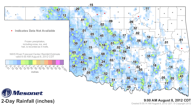
Congrats to all of you under the green, which will hopefully transform some of
the yellow around you. The Hinton rain gauge was the best positioned to sample
some of that moisture and rang up a 1.16 inches bullseye. Congrats to Watonga
as well for being removed from the days without a quarter or a tenth of an inch
tally.
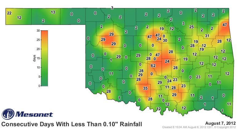
Norman still reigns supreme on the tenths map at 62 days. There were a few
showers that managed to graze parts of Norman with some heavier rain but most
of the area still remained in the light stuff. I can tell you that at my house,
it basically sprinkled for 4 hours and just made it nasty to go outside.
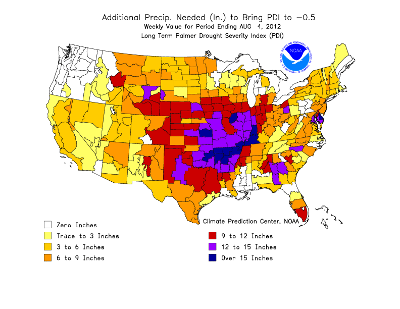
Now, what did this do for the drought? Oh, not much, really. This graphic of
additional rainfall needed to end the drought from the Climate Predication
Center will give you an idea of what we face.
In those localized areas that received a half to an inch of rain, they will get
some green-up. The top layer of soil will soak that water up and it will be
evaporated back to the atmosphere pretty quickly, even if we weren't
experiencing above normal temperatures. You can watch what happens with the
soil moisture at Hinton, for instance. Using our new soil moisture graphs, you
can see the onset of the drought conditions over the last 90 days, and also see
how the rains slightly moistened the soils last night.
http://www.mesonet.org/index.php/weather/soil_moisture/hint
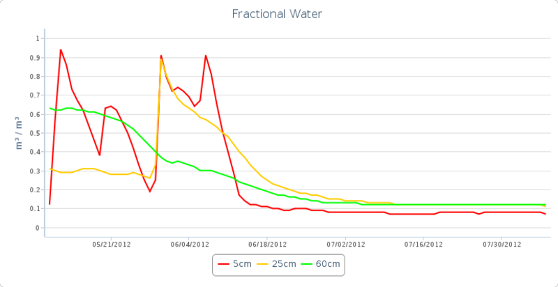
But you can also see why it becomes difficult for a singular rainfall event to
"cure" a drought. Rains show up on that map as the 5cm soil moisture spikes in
May and June. Rains come, moisten the topsoil, then it doesn't rain again for
awhile and the sun goes to work on the soils. And all through that period, not
enough reinforcing rains occur to wet the sub-surface soils. Wetting the topsoil
does not end a drought, unfortunately. It is the beginning of the process,
however. So watch that red curve at Hinton and see how high it goes, but the
gold and green curves are gonna have to follow suit.
What happens to the soils during a time when it doesn't rain more than a tenth
of an inch in any single day for over 60 days? Take a look at Norman's soil
moisture graph along with their soil temperature graph.
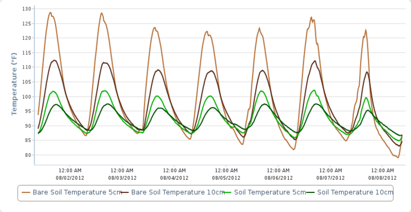
The onset of flash drought is painfully obvious from mid-May through July. A
nice rain (heck, Norman's LAST nice rain) at the end of May moistened the
topsoil and the 25cm subsoils. It didn't do much for the 60cm depth. Then you
see another small rain in early June that just helped the topsoils, then the
long march forward with no rainfall and a steady decline in soil moisture.
Add to that the baking of the soils (bare soil temps up to 130 degrees!!!) which
adds to the extreme heat, which diminishes the soil moisture even further, which
worsens the drought ... (and so on and so on).
Those soil moisture and temperature graphs I showed you? That is flash drought.
You can check out our new soil moisture and soil
temperature graphs for the location nearest you right here:
http://www.mesonet.org/index.php/weather/category/soil_moisture_temperature
Now that it appears that heat dome is going to shift to the west for awhile and
help keep us close to normal instead of ridiculously above normal, I hope we
can piecemeal some relief together from each of these bouts with isolated
showers and storms. It won't be widespread relief just yet, probably, but a
few pimples of green amidst our sea of yellow would be nice.
Gary McManus
Associate State Climatologist
Oklahoma Climatological Survey
(405) 325-2253
gmcmanus@mesonet.org
August 8 in Mesonet History
| Record | Value | Station | Year |
|---|---|---|---|
| Maximum Temperature | 111°F | KIN2 | 2011 |
| Minimum Temperature | 53°F | EVAX | 2017 |
| Maximum Rainfall | 4.48″ | WIST | 2023 |
Mesonet records begin in 1994.
Search by Date
If you're a bit off, don't worry, because just like horseshoes, “almost” counts on the Ticker website!