Ticker for July 8, 2011
MESONET TICKER ... MESONET TICKER ... MESONET TICKER ... MESONET TICKER ...
July 8, 2011 July 8, 2011 July 8, 2011 July 8, 2011
Hot day in the big city
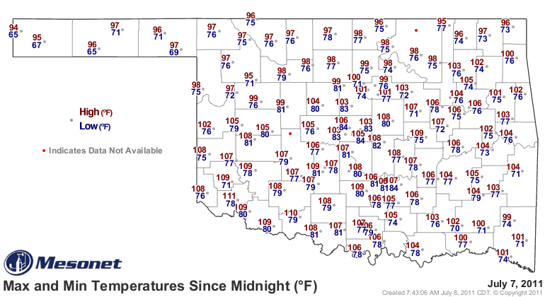
Yesterday's high temperature of 108 degrees obviously broke a record, although it
was closer than I thought it would be. The previous record for July 7 in Oklahoma
City was 106 degrees set back in 1996. The mark is also tied for the ninth
highest temperature recorded in Oklahoma City since 1896. Here are the top highs
through 108 degrees.
1936/08/11 113 1936/07/18 108
1936/08/10 112 1966/07/19 108
1936/08/12 110 1980/07/29 108
1980/08/02 110 1980/08/01 108
1996/07/06 110 1986/07/28 108
1936/07/19 109 1986/07/30 108
1936/08/09 109 1996/07/05 108
1986/07/29 109 2000/09/02 108
1909/08/17 108 2000/09/03 108
1936/07/15 108 2011/07/07 108
So the highest temperature in OKC in the last 11 years is nothing to sneeze at.
Feel free to sweat, however. Tulsa also broke its record high yesterday with 104
degrees. The previous record was 103 degrees, set back in 1917.
How about statewide? We averaged the Mesonet temperatures statewide (highs +
lows, divide by 2 so as to match up with the COOP methodology) and found an
average temperature of 89.8 degrees. That marks July 7th as the warmest day
across the state so far this year. Here are the top-5.
2011/07/07 89.8
2011/06/26 89.6
2011/06/27 88.8
2011/06/25 88.0
2011/06/30 87.9
Wow, very impressive! How does that stack up to Oklahoma's historical record?
We did the same thing for Oklahoma's COOP records dating to 1915 and found
yesterday's warmth stacks up with some of the hottest days on record. The 89.8-
degree statewide average temperature yesterday is tied for the 129th warmest
day in the state. That might not seem that high, but we're talking more than
31,000 days back. (note: we started in 1915 since we're looking at a statewide
average and we wanted at least 70 stations to work with)
At the top of the list is August 12, 1936, at 94.9 degrees. The previous day --
August 11, 1936 -- comes in a close second at 94.2 degrees. Here's the top-10.
Notice all the 1934s, 1936s, and 1954s (i.e., drought years).
1936/08/12 94.9
1936/08/11 94.2
1936/07/19 94.0
1936/08/10 94.0
1936/08/09 93.9
1936/08/13 93.8
1954/07/14 93.8
1934/08/01 93.7
1934/08/12 93.6
1936/07/18 93.4
Here's what August 12, 1936, looks like on a weather map. Doesn't look like too
much fun, but neither does this July 7, 2011, either. For the August 12 map,
highs are in black and lows are in red.

Want to cool off? Think back to February 2 of this year when the average
statewide temperature was 9.7 degrees. What the heck, why stop there? Go back
to the coolest day on record ... December 22, 1989. The statewide average
temperature was 1.8 degrees.
Brr.
Gary McManus
Associate State Climatologist
Oklahoma Climatological Survey
(405) 325-2253
gmcmanus@mesonet.org
July 8 in Mesonet History
| Record | Value | Station | Year |
|---|---|---|---|
| Maximum Temperature | 109°F | WAL2 | 2022 |
| Minimum Temperature | 50°F | WIST | 2006 |
| Maximum Rainfall | 5.63 inches | SALL | 2025 |
Mesonet records begin in 1994.
Search by Date
If you're a bit off, don't worry, because just like horseshoes, “almost” counts on the Ticker website!