Ticker for July 7, 2011
MESONET TICKER ... MESONET TICKER ... MESONET TICKER ... MESONET TICKER ...
July 7, 2011 July 7, 2011 July 7, 2011 July 7, 2011
Drought continues its eastward march
It's a tired story now (and tragic for many western Oklahomans), but the drought
of 2010-11 continues punishing the Southern Plains and Oklahoma. Given the
season, prospects for widespread relief are less than promising. The latest U.S.
Drought Monitor report released this morning now has moderate drought covering
most of eastern Oklahoma. Severe-to-extreme drought continues spreading east as
well with most of western Oklahoma within the exceptional drought category.
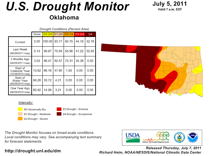
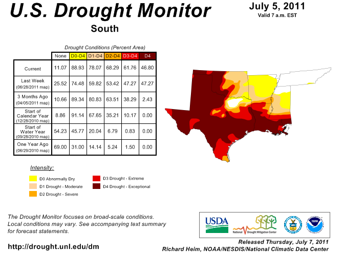
Almost 94% of the state is now covered by drought of varying severity. The story
is the same for much of the Southern Plains.
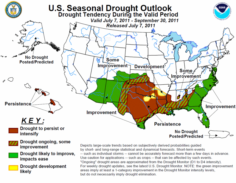
The latest U.S. Seasonal Drought Outlook from the National Weather Service once
again paints a bleak picture for relief through September. Their forecasters
expect the drought to persist or intensify for most of Oklahoma, with drought
development likely in southern and eastern Oklahoma. The only area with some
possible improvement indicated is northwestern Oklahoma due to its proximity
to the Desert Southwest summer monsoon.
Much of western Oklahoma is experiencing its driest October 1-July 6 since at
least 1921.
Climate Div. Total Dep. of Normal Pct of Normal Rank since 1921
Panhandle 5.60" -9.08" 38% 1st driest
N. Central 11.53" -11.54" 50% 4th driest
Northeast 22.27" -9.19" 71% 11th driest
W. Central 9.44" -12.19" 44% 1st driest
Central 14.48" -14.70" 50% 3rd driest
E. Central 26.48" -9.37" 74% 20th driest
Southwest 10.24" -12.72" 45% 1st driest
S. Central 15.96" -16.07" 50% 3rd driest
Southeast 28.94" -11.83" 71% 14th driest
Statewide 15.94" -11.96" 57% 3rd driest
High temperatures continue to run 8-9 degrees above normal since June 1. The
average high temperature in southwestern and west central Oklahoma has
averaged 102 degrees and 101 degrees over that period, respectively. The
Altus Mesonet site has reached 100 degrees for 15 consecutive days and for
33 out of the last 35.
The bad news is the hottest part of the year (normally) is still ahead of us.
The good news ... winter is only five months away??
Gary McManus
Associate State Climatologist
Oklahoma Climatological Survey
(405) 325-2253
July 7 in Mesonet History
| Record | Value | Station | Year |
|---|---|---|---|
| Maximum Temperature | 111°F | ALTU | 2011 |
| Minimum Temperature | 52°F | ANTL | 2006 |
| Maximum Rainfall | 5.20 inches | KIN2 | 2024 |
Mesonet records begin in 1994.
Search by Date
If you're a bit off, don't worry, because just like horseshoes, “almost” counts on the Ticker website!