Ticker for September 6, 2012
MESONET TICKER ... MESONET TICKER ... MESONET TICKER ... MESONET TICKER ...
September 6, 2012 September 6, 2012 September 6, 2012 September 6, 2012
When it rains, it droughts
Decent rains have fallen across western Oklahoma over the last couple of days, a
much-welcomed if somewhat unexpected drought-denter (Stop me before I hyphenate
again!). Most of the totals hovered between a half-inch to an inch, although there
were a few localized areas that appear to have received up to 2.5 inches
according to radar estimates. VERY localized. Somebody got lucky for sure.
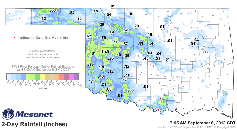
Now these rains have fallen after the 7am Tuesday cutoff time for this week's
U.S. Drought Monitor map, so we'll deal with these rains on next week's map. More
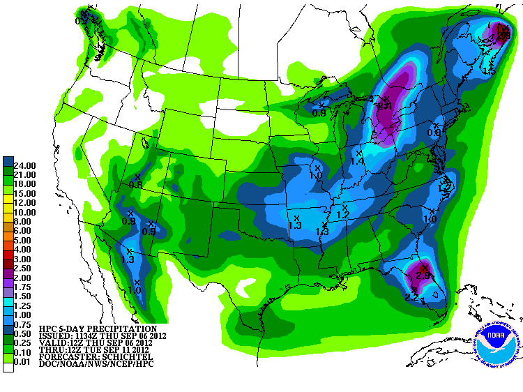
rain and cooler weather is right around the corner, so there is a great chance
for reinforcing relief. The latest 5-day rainfall forecast from the HPC still
sees a good half-inch to over an inch across the eastern half of the state, with
a bit less across western Oklahoma.
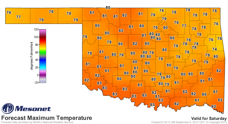
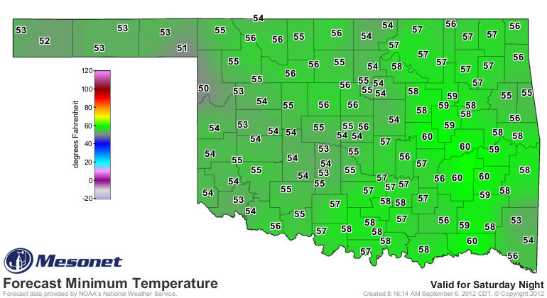
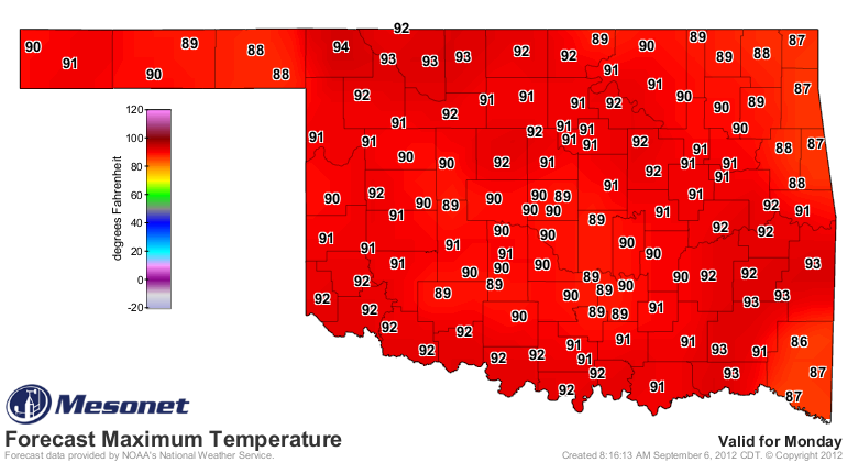
And that will come with the aforementioned below normal temperatures, at least
for a couple of days. It looks like back into the heat on Monday, however, so a
nice cool weekend will be a great payoff.
But let's get to the main event. The latest U.S. Drought Monitor, owing to the
continued lack of rainfall through much of the last 10 days or so in addition
to the above normal temperatures, saw more of the state slide into exceptional
drought ... specifically, the Oklahoma Panhandle.
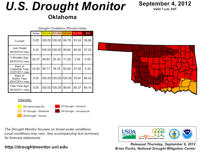
That pushed the exceptional drought coverage across the state to 40 percent,
a slight increase from last week's 37 percent. So very little changed after last
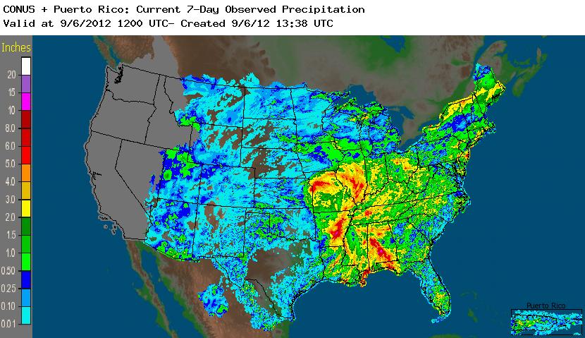
week's improvements. We had hoped to see large improvements across eastern
Oklahoma with a little help from Hurricane Isaac, but he took his riches to the
east in Arkansas and Missouri and then farther northeast. That is fairly
obvious when you look at the radar-estimated rainfall map from the last seven
days.
And that is also reflected in the expanded Drought Monitor map, with large-scale
improvements from Louisiana into the upper Midwest.
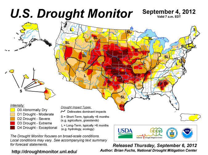
Those maps do illustrate why Oklahoma, Kansas and Nebraska have become the
centerpiece of the drought, however. Over 70% of Nebraska and 60% of Kansas
are now in exceptional drought. So 170 percent of those three states are in
exceptional drought! No, wait. My math is wrong. How about 57 percent. And
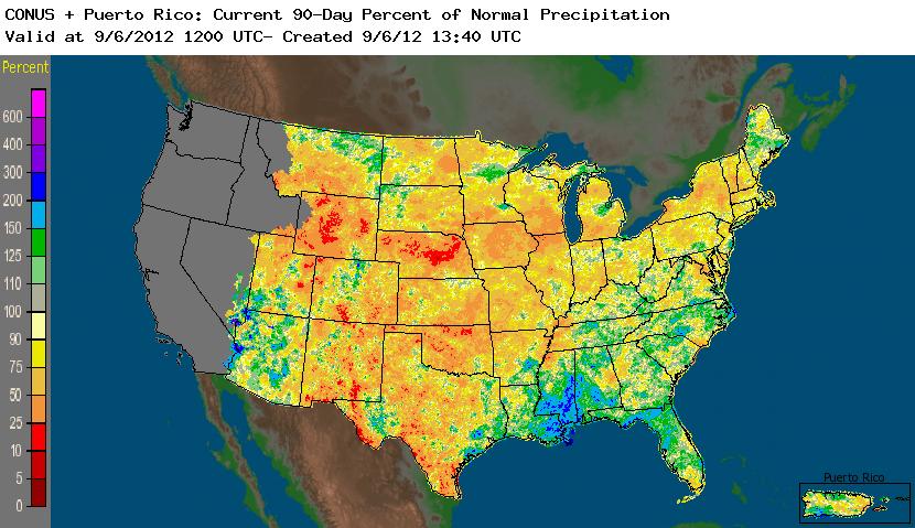
again, it's easy to see why. This map of radar-estimated percent of normal
rainfall for the last 90 days makes me glad we're not suffering Nebraska's fate.
Our measly rains look torrential in comparison, although north central Oklahoma
is trying to match them.
Closer to home, the last 90 days as measured by the Mesonet are just as ugly,
so we'll go even more ugly and look at rainfall since May 1. That encompasses
a lot of the prime rainy season in Oklahoma (May through mid-June). And this
includes last night's rains.
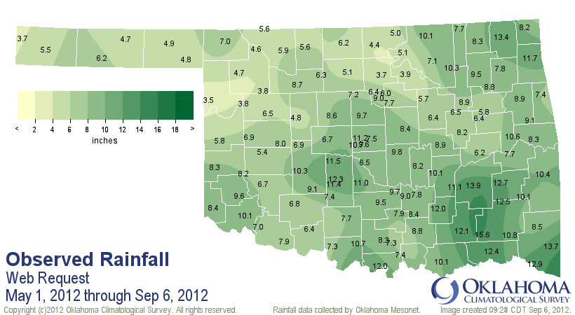
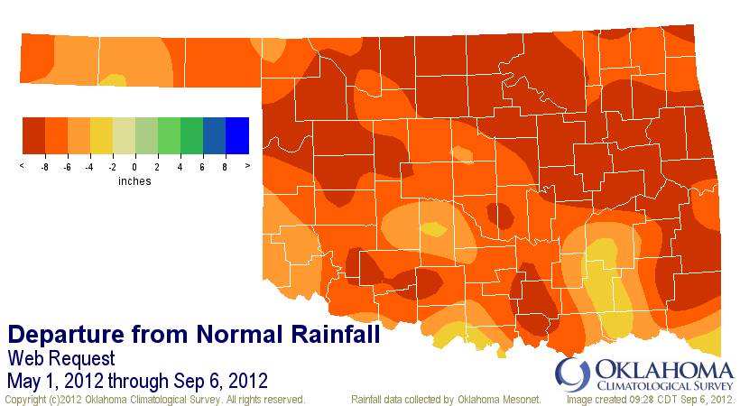
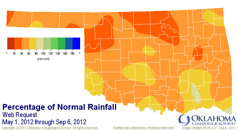
Much of the state remains at less than 60 percent of normal through that period,
with portions of northwestern and north central Oklahoma even lower than that.
Those places generally have between 3.5 and 5 inches of rainfall for the last
five months. For the state, it's the driest such period dating back to 1921, so
significantly dry.
-****-
Region Avg. Tot Dep. Pct. Norm
Panhandle 5.06" -6.62" 43% 1st driest
N. Central 5.37" -10.08" 35% 1st driest
Northeast 8.44" -8.91" 49% 2nd driest
W. Central 6.42" -7.75" 45% 4th driest
Central 8.66" -7.34" 54% 5th driest
E. Central 8.80" -8.63" 50% 2nd driest
Southwest 8.10" -6.38" 56% 5th driest
S. Central 9.18" -6.58" 58% 10th driest
Southeast 11.97" -6.32" 65% 10th driest
Statewide 7.97" -7.65" 51% 1st driest
-***-
The latest drought outlook from the NWS' Climate Prediction Center doesn't have
much hope for us here in the Southern and Central Plains, but this outlook is
certainly not the last word.
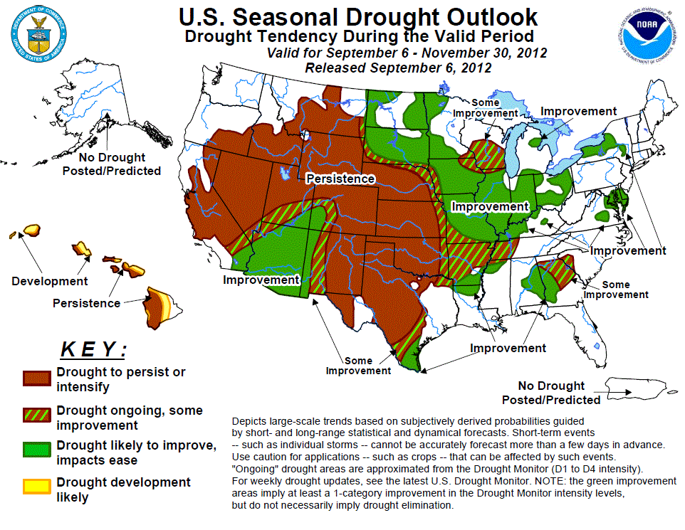
Their reasoning in their words:
"... across the High Plains and the central and southern reaches of
the Great Plains ? no drought relief is forecast. Climatologically,
this region progresses toward their drier time of year during autumn,
reducing the prospects for heavy precipitation and resultant drought
relief. Also, some dynamic models lean toward near- to below-normal
precipitation during this already dry time of year, further reducing
chances for relief."
I'll just say that to get to that drier time of the year for our area (Nov.-Feb.),
we get to plow through a secondary rainy season during September and October.
At least for the eastern two-thirds of the state. The weather really starts to
cool down during this period as well, so the relief is more well-received by
the ecosystem.
Now those dynamic models need to straighten up and maybe they'll be well-received
as well!
Gary McManus
Associate State Climatologist
Oklahoma Climatological Survey
(405) 325-2253
gmcmanus@mesonet.org
September 6 in Mesonet History
| Record | Value | Station | Year |
|---|---|---|---|
| Maximum Temperature | 107°F | FREE | 2015 |
| Minimum Temperature | 40°F | OILT | 2011 |
| Maximum Rainfall | 3.74 inches | MEDF | 2008 |
Mesonet records begin in 1994.
Search by Date
If you're a bit off, don't worry, because just like horseshoes, “almost” counts on the Ticker website!