Ticker for August 6, 2020
MESONET TICKER ... MESONET TICKER ... MESONET TICKER ... MESONET TICKER ...
August 6, 2020 August 6, 2020 August 6, 2020 August 6, 2020
Summer's not here Mrs. Torrance

BOOM! How about that, huh? Now we're cooking with gas. We now have just a little
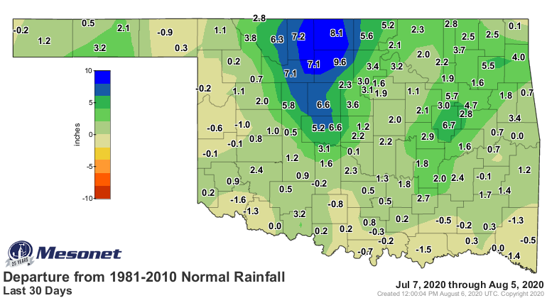
more than 21% of the state in any type of drought, thanks to the generous
rainfalls over the last 30-45 days or so. You can see where we had improvements
this week in the lower part of the image, in some cases a rare 2-category
improvement up in northeastern Oklahoma. Look at the last month and you can see
where the biggest changes have occurred, and also the areas we're still worried
about.

The Mesonet rainfall maps tell the story, especially over the last 30 days,
which includes much of that glorious July rainfall in the second half of the
month.
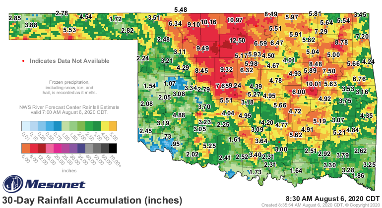

You can also see the worrisome areas, across southern and west central Oklahoma.
MAYBE we get some help again today, at least in the northwest. We're going to
have to wait and see if this blob of storms in NW OK can travel very far to the
south before it breaks up. Unfortunately (at least for those in the southern
parts of the state. Looks a bit localized. There is a bit of a chance for
severe weather, but it's August, so don't go thinking all May on us.


This rainfall could be important because summer is going to come roaring back.
It will be a shock to the system as we've had such a cool end to July and start
of August, after a pretty normal-ish looking summer; sometimes really hot,
sometimes a bit cooler, and then BLAMMO (official scientific term...I didn't
just make that up!).

Now the real question is...are you a happy Jack Torrance, or are you a frozen
Jack Torrance? And maybe some of you would be a happy Jack Torrance on the cool
side of that graph when the statewide avg. summer temps plunge up to 8-9 degrees
below normal here lately in August? Well, at any rate, all Jack Torrances end
up the same, but that's a different horror novel. Speaking of horror, check out
the forecast temps for tomorrow.

EEK!
And then later into next week.


YEEARGHHH!!!
Not sure what that last sound was, but it was supposed to imply fear. But that's
okay. A little bit of fall during summer is a good thing, but we always have
to be ready for summer's return until fall REALLY takes over. You know, sometime
in November.
Gary McManus
State Climatologist
Oklahoma Mesonet
Oklahoma Climatological Survey
(405) 325-2253
gmcmanus@mesonet.org
August 6 in Mesonet History
| Record | Value | Station | Year |
|---|---|---|---|
| Maximum Temperature | 112°F | OKMU | 2011 |
| Minimum Temperature | 54°F | BOIS | 1998 |
| Maximum Rainfall | 6.70″ | HUGO | 2017 |
Mesonet records begin in 1994.
Search by Date
If you're a bit off, don't worry, because just like horseshoes, “almost” counts on the Ticker website!