Ticker for September 4, 2012
MESONET TICKER ... MESONET TICKER ... MESONET TICKER ... MESONET TICKER ...
September 4, 2012 September 4, 2012 September 4, 2012 September 4, 2012
How did August and the Summer stack up?
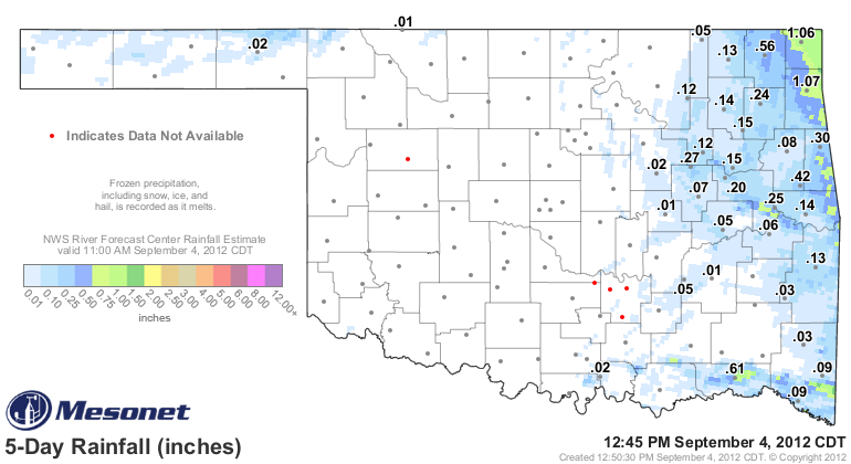
Before we get to the summary, Isaac turned out to be a dud. About an inch fell in
far northeastern Oklahoma. Sorry, the Ticker definitely tried to coax it our way,
but it was not meant to be.
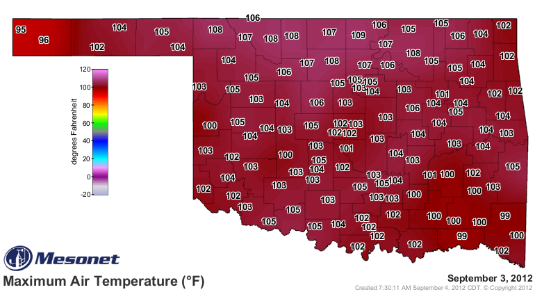
In the meantime, the dreaded upper-level high found the drought waiting for it
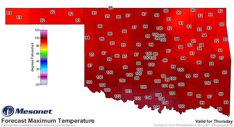
in Oklahoma and the heat has returned with a vengeance. Yesterday saw nearly the
entire state head for triple-digits. In fact, Sept. 3, 2012, was the ninth
hottest September day on record in the state with an average (highs and lows
averaged together) of 88.3 degrees. Sept. 3, 1939, is tops at 90.6 degrees. All
of September's top-10 hottest days occurred in the first four days of the month.
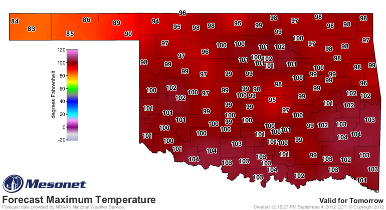
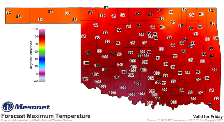
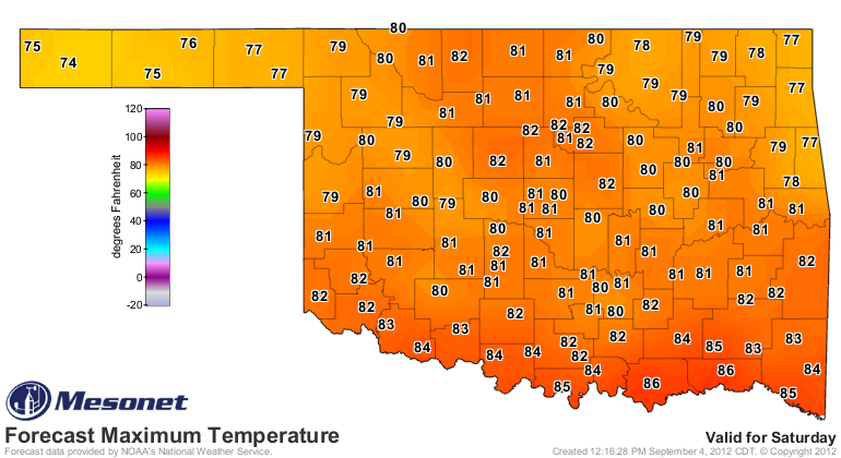
We have several hot days left before the bottom drops out on Saturday and we get
a brief glimpse of fall weather again.
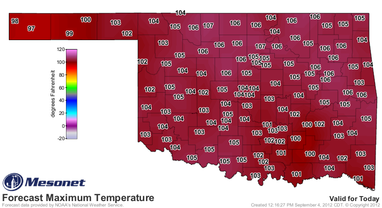
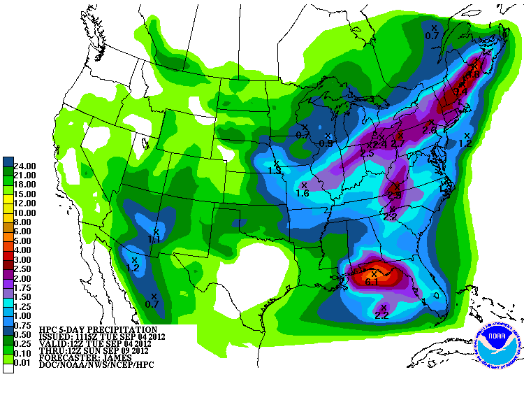
A few preliminary systems before the biggie on Friday will also keep our rain
chances up for the next few days. Unfortunately, it doesn't look like a
drought-buster at this time.
Enjoy it while you can. Well, Friday, at least. Might be Saturday though. How's
that for a forecast?
One correction below, we actually looked at the latest data and Aug. 2, 2012,
was even hotter than Aug. 1. The 2nd came in with a statewide average
temperature of 94.1 degrees, tying it with august 10, 1936, as the FOURTH
hottest day in state history. Yikes, that's hot! That's also hotter than any
single day last year (Aug. 2, 2011, was 93.9 degrees). Anyway, here is your new
top-10 hottest days in Oklahoma history.
-****-
Year Month Day Avg. Temp
1936 8 12 94.9
1936 7 19 94.3
1936 8 11 94.2
1936 8 10 94.1
2012 8 2 94.1
1936 8 9 93.9
1954 7 14 93.9
2011 8 2 93.9
1934 8 1 93.8
1936 8 13 93.8
-***-
Anyway, with that gruesome news added, on with the show this is it!
--------------------------------------------------------------------------------
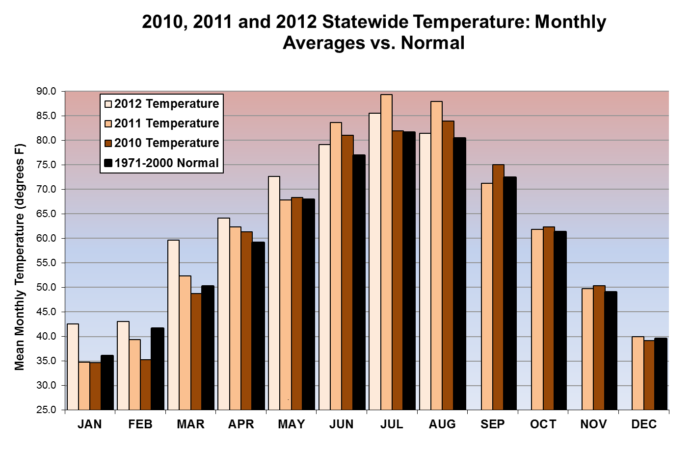
According to data from the Oklahoma Mesonet, August finished one degree above
normal to rank as the 53rd warmest on record and a half an inch below normal to
come in as the 42nd driest. Those records date back to 1895. Despite those
seemingly benign statistics, August actually had weather to suit just about all
summer appetites. The month started with one of the hottest stretches the state
has ever experienced, moved to mild and wet for a spell, then ended once again
on the hot side. Unfortunately, that brief fall-like interlude in the middle of
the month did little to quell the ongoing flash drought event that began in
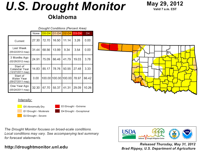
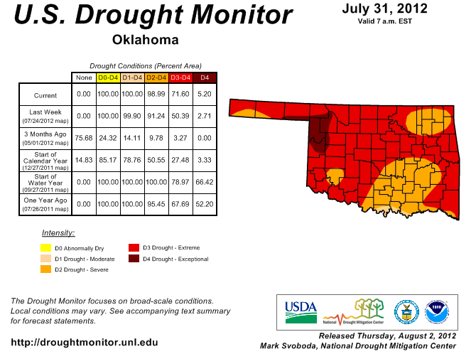
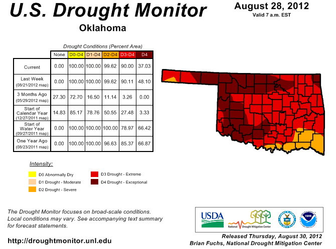
late spring. The U.S. Drought Monitor report released on August 28 showed 37
percent of Oklahoma mired in exceptional drought, with 90 percent portrayed in
extreme-exceptional drought. The Drought Monitor?s intensity scale slides from
moderate-severe-extreme-exceptional, with exceptional being the worst category.
To exemplify the drought?s rapid advance, only 17 percent of the state was in
drought at the end of May and five percent was in exceptional drought at the
beginning of August.
Vegetation that had flourished in the wet and unusually warm winter and early
spring became prime fuel for wildfires thanks to the heat and drought. More than
100,000 acres across the state burned in early August, with one fatality east
of Norman attributed to wildfire.
The weather during early August was as intensely hot as nearly any in the
state?s history with temperatures ranging from 105-115 degrees across much of
Oklahoma. August 2 became the state?s fourth hottest day on record with a
statewide average temperature of 94.1 degrees. That is still 0.8 degrees less
than Oklahoma?s hottest day on August 12, 1936.
Oklahoma City tied its all-time record high temperature and broke its all-time
record warm low temperature on the same day, August 3, with readings of 113
degrees and 84 degrees, respectively. The highest temperature recorded by the
Oklahoma Mesonet during the month was 115 degrees from Kingfisher on August 1.
On the cool side, several Mesonet stations reached a minimum temperature of 50
degrees on August 20.
The end of August also brings the climatological summer to a close, and it was
obviously a hot and dry one. The statewide average rainfall total during summer
fell 3.7 inches below normal to rank as the 14th driest on record. The summer
also ranked as the 12th warmest on record at 2.5 degrees above normal. The
first eight months of the year ended as Oklahoma?s warmest January-August
period on record at 4.3 degrees above normal. August was the 24th month out of
the last 29 to finish warmer than normal, beginning with April 2010.
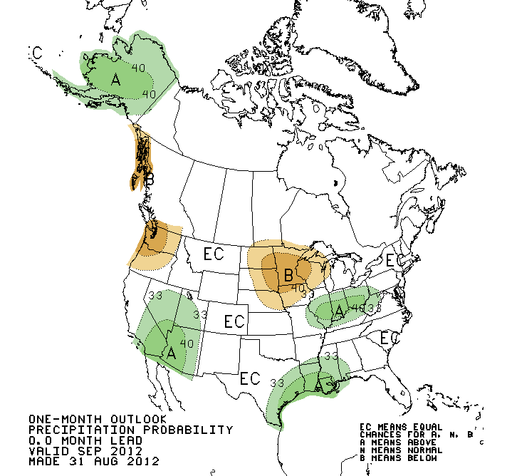
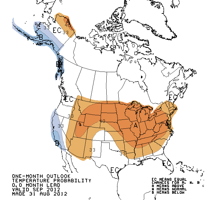
The September temperature and precipitation outlooks from the National Weather
Service?s Climate Prediction Center (CPC) hold few clues on what to expect for
the next month. Most of the state is given equal chances for above-, below- or
near-normal rainfall and temperatures, although the eastern half of the state
is given slightly increased odds for warmer than normal weather.
Farther out, the world awaits the arrival of El Ni?o. That warming of the
waters in the tropical eastern Pacific Ocean can impact weather patterns across
the globe. One of its impacts is to provide increased chances for cooler and
wetter weather across the southern tier of the United States during the cool
season (October-March). The impacts are often not as strong for Oklahoma as its
counterparts farther south and east, but data suggest moderate-to-strong El
Ni?o events increase the odds for a wetter cool season across Oklahoma. In the
event of a weak El Ni?o, drier weather is often the result. While El Ni?o is
almost certain, and has possibly already developed, its intensity is still
uncertain at this time.
Gary McManus
Associate State Climatologist
Oklahoma Climatological Survey
(405) 325-2253
gmcmanus@mesonet.org
September 4 in Mesonet History
| Record | Value | Station | Year |
|---|---|---|---|
| Maximum Temperature | 112°F | WALT | 2000 |
| Minimum Temperature | 43°F | BOIS | 2008 |
| Maximum Rainfall | 4.22″ | MANG | 1996 |
Mesonet records begin in 1994.
Search by Date
If you're a bit off, don't worry, because just like horseshoes, “almost” counts on the Ticker website!