Ticker for September 3, 2024
MESONET TICKER ... MESONET TICKER ... MESONET TICKER ... MESONET TICKER ...
September 3, 2024 September 3, 2024 September 3, 2024 September 3, 2024
It has begun
Summer has an expiration date, you know. It doesn't just get to keep going and
going and going, thanks to pesky orbital mechanics and planetary tilt. This is
very similar to my hair mechanics and baldetary tilt. So when we start seeing
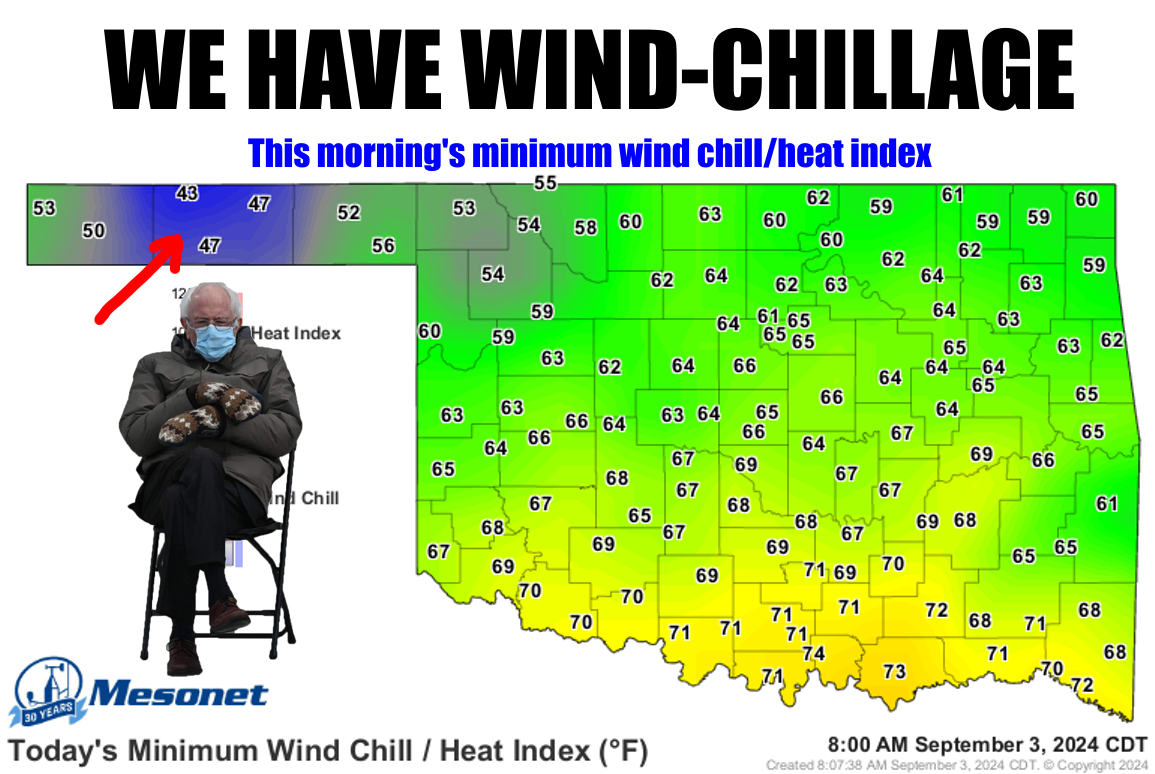
wind chills show up in the state (the Panhandle more often than not) for the
first time in the fall, it is indeed all downhill from there. And that's
CLIMATOLOGICAL fall...meteorologists get all the day-to-day weather fun, we
climatologists get the seasonal fun, thank you very much! At any rate, fall
started on Sept. 1 and it looks like it on the weather maps as well. Wind chills
don't kick in until you get to an actual air temperature of 50 degrees, and then
you need wind of course. And to be outside. And have exposed skin. Not TOO MUCH
exposed skin, or you'll end up locked in a cell where there probably is no
wind chill.
So those lows in the 40s in the Panhandle just needed a bit of wind and poof!
It could be worse, though. Amember this?
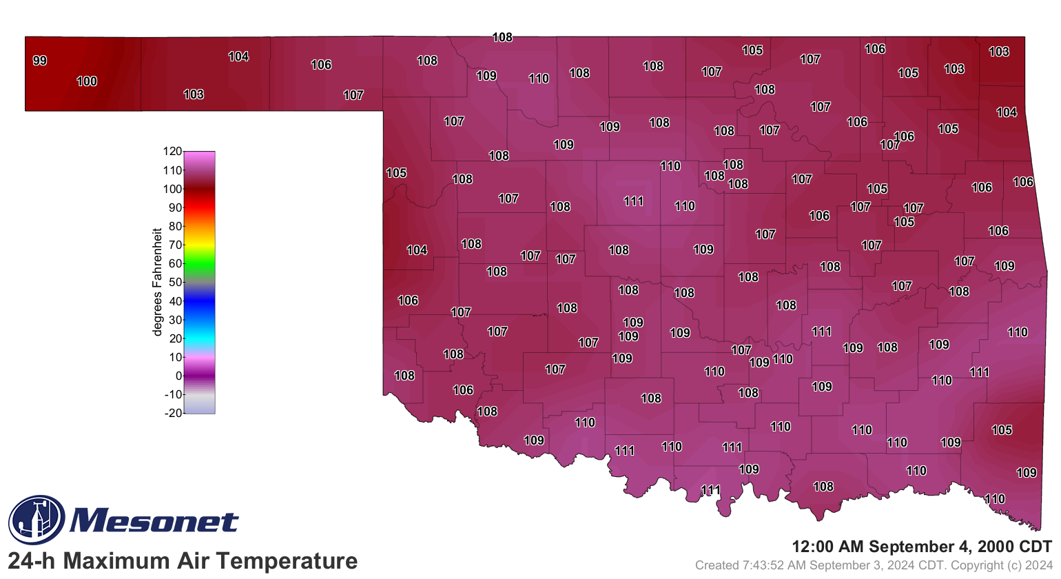
Right, THE hottest September 3 in state history. I remember it because it was the
day after I attended the OU/UTEP game in Norman and nearly hit my expiration date.
Coincidentally, this is also the same time frame my hair hit its expiration date.
What, TWO bald jokes in ONE Ticker!?!
While we're talking about bad news (hair, not wind chills, although I'm not in
favor of wind chills either), the rain forecast mostly fizzled, although heck,
it's raining right now for crying out loud! It's just not amounting to much.
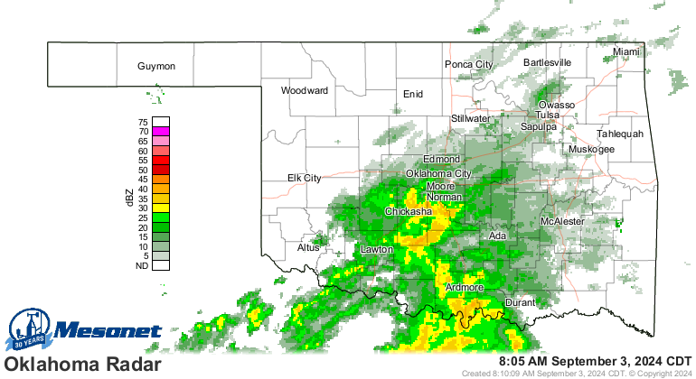
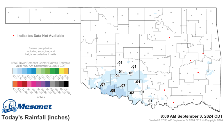
But it is rain, and we'll take what we can get...the forecast doesn't look
promising.

That doesn't look very State-Fair'ish to me. Oh well, stick around down below
for a look back at August, and even a look forward to September.
---------------------------------------------------------------------------------
Drought Expands Despite Historic Rainfall
Sept. 3, 2024
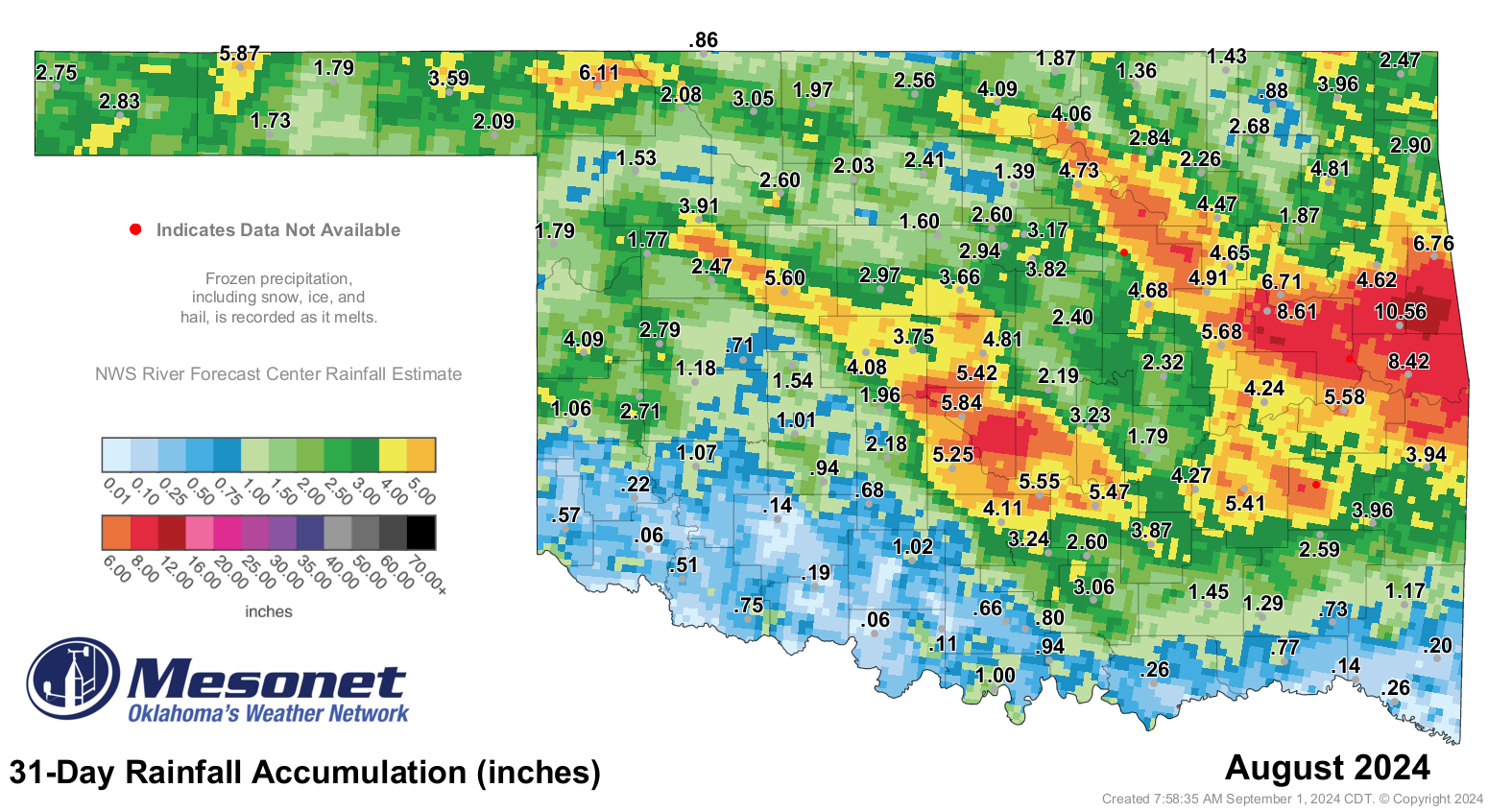
In a display of Oklahoma’s famously chaotic weather patterns, August brought
historic rains to portions of central and eastern Oklahoma while drought
continued to intensify and spread over other sections of the state. A remarkable
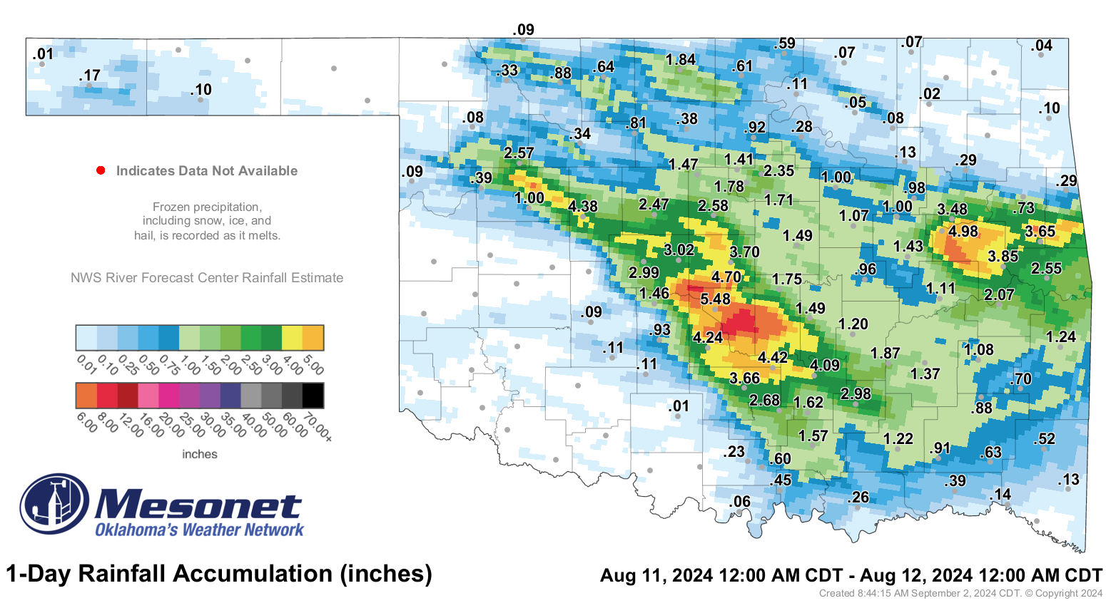
6 to 12 inches of rain fell from northwest to central Oklahoma within 12 hours
on Aug. 11, with a volunteer observer near Noble in Cleveland County recording
11.01 inches—a 500-year rainfall event according to NOAA statistics. Oklahoma
City set a new record for its highest single-day August rainfall at 6.58 inches,
surpassing the previous mark of 5.06 inches set on Aug. 14, 2018. This also
ranked as the city’s seventh-highest daily total for any month on record,
dating back to 1890. The deluge caused widespread flash flooding, leading to
flooded homes and businesses, road closures, and water rescues. Eastern
Oklahoma also saw significant rainfall that day, with 4 to 8 inches falling in
and around Muskogee County. Another heavy rain event of 4 to 8 inches occurred
in far east-central Oklahoma on Aug. 16-17, primarily affecting Adair and
Cherokee counties.

While these rains eradicated drought conditions locally, drought spread and
intensified across other parts of the state. Images of dry farm ponds, dead or
dormant pastures, and decimated crops emerged from the drought-afflicted
regions. This deterioration was driven by extended periods without significant
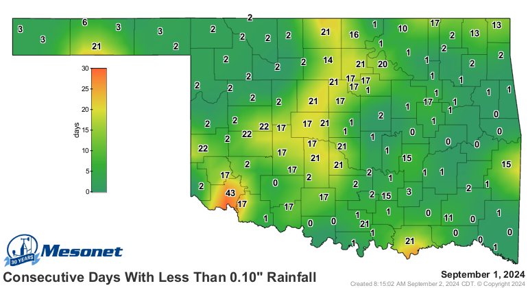
rainfall and persistent above-normal temperatures. Southwest Oklahoma had its
ninth-warmest August since 1895, with temperatures averaging 4 degrees above
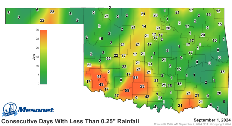
normal thanks to nearly daily triple-digit highs. By late August, the region
had gone 60 to 90 days without a quarter-inch of rain in a single day and over
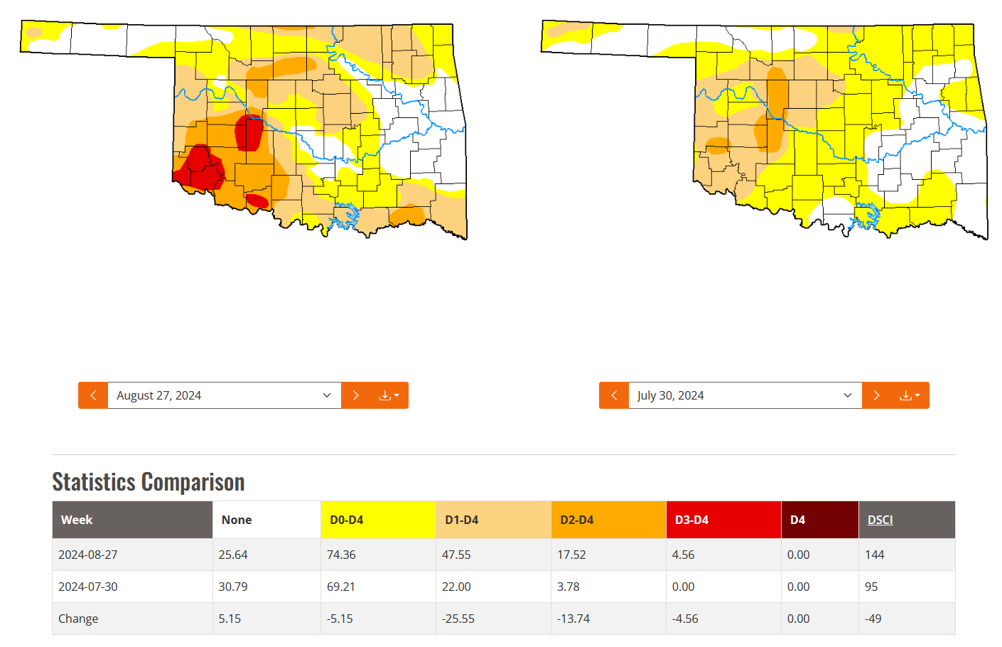
40 days without even a tenth of an inch. According to the U.S. Drought Monitor,
drought coverage more than doubled during August, rising from 22% at the end of
July to 48% by the end of August—the highest amount of drought in the state
since Oct. 23, 2023. Severe and extreme drought also expanded from 4% to 18%,
primarily across the southwestern quarter of the state.
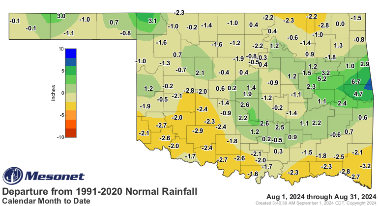
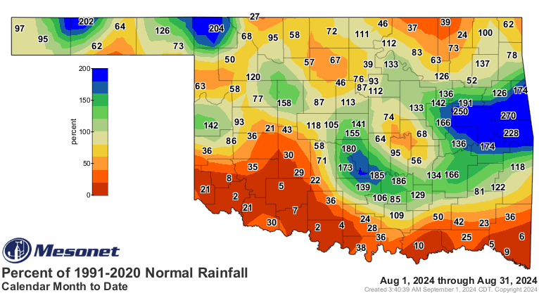
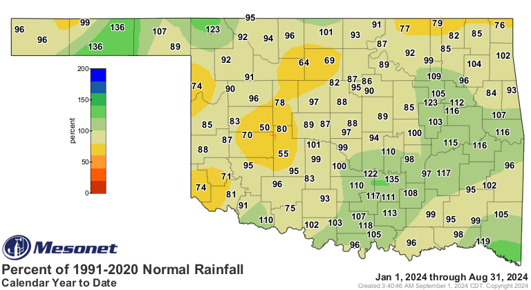
Oklahoma’s statewide average rainfall for August, as recorded by the Oklahoma
Mesonet, was 2.8 inches—0.43 inches below normal—ranking as the 65th-wettest
August since records began in 1895. Mesonet rainfall totals varied significantly
across the state, from a high of 10.56 inches at Cookson to just 0.06 inches at
both Altus and Waurika. Notably, a volunteer observer near Bunch in Adair
County recorded 13.04 inches, while another near Noble in Cleveland County
reported 11.1 inches for the month. Thirty-two of the Mesonet’s 120 sites
recorded at least 4 inches for the month, 17 of those above 5 inches. However,
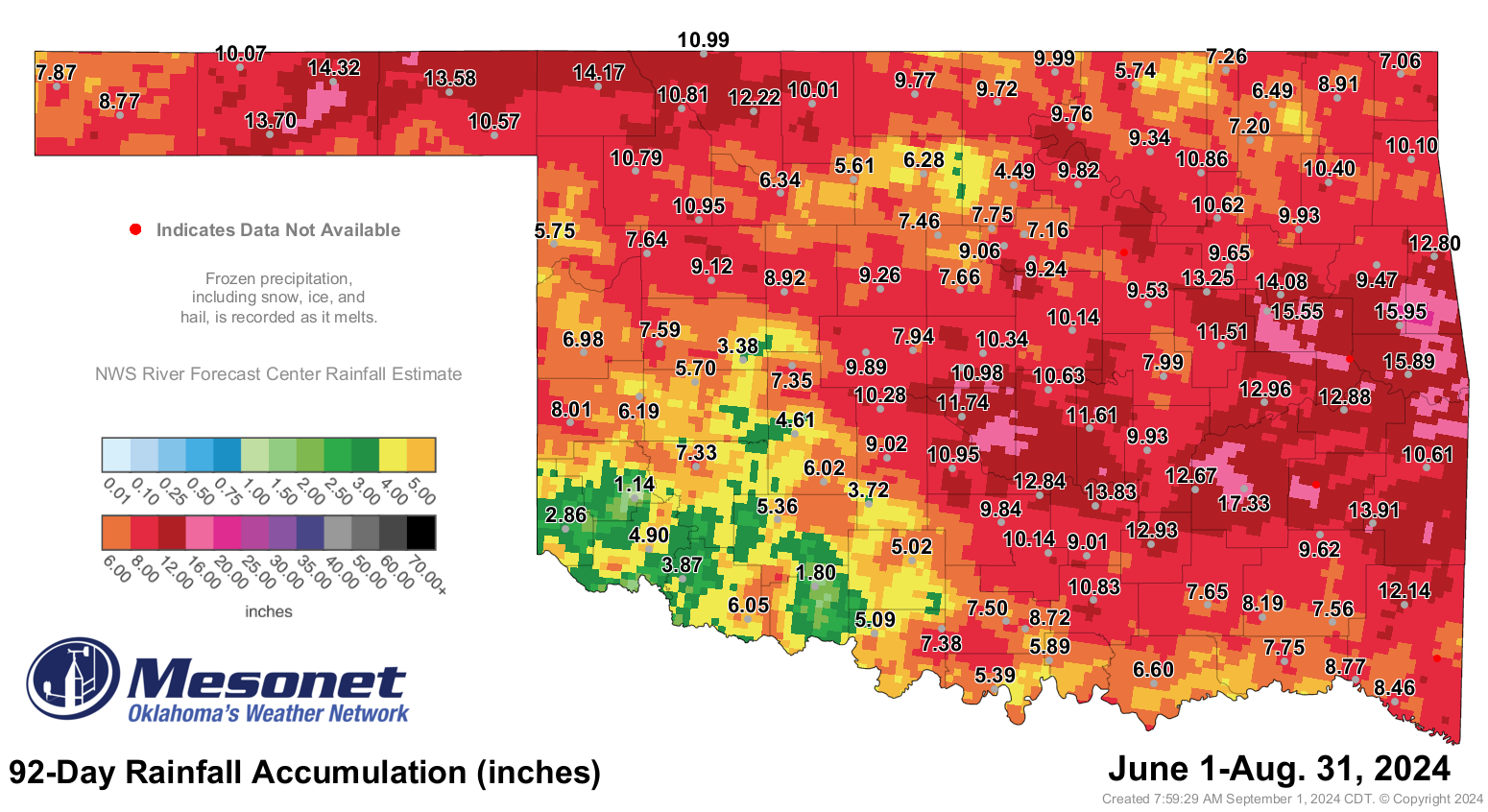
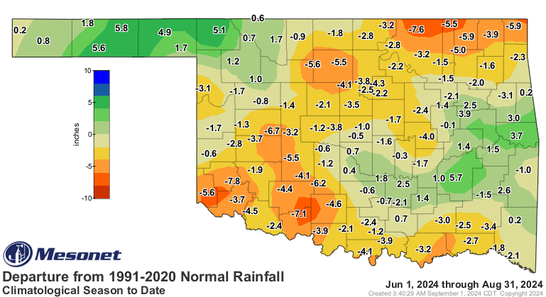
47 sites saw less than 2 inches. For the climatological summer (June-August),
the statewide average rainfall was 9.34 inches—1.35 inches below normal—ranking
as the 54th-driest summer on record. Summer totals ranged from 17.33 inches at
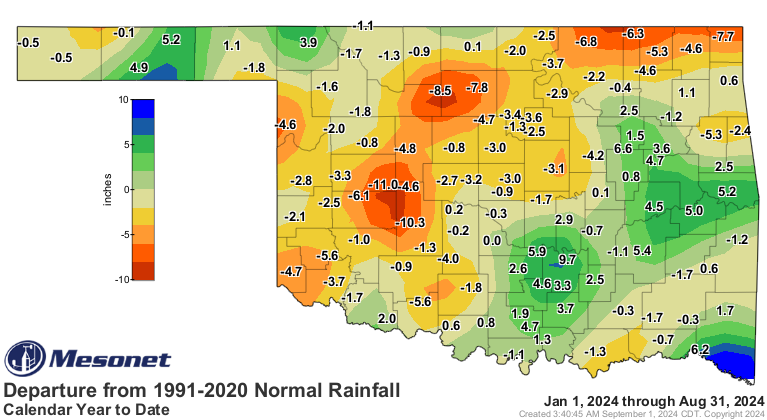
McAlester to just 1.14 inches at Mangum. The January-August average of 24.64
inches was 0.61 inches below normal, ranking as the 51st-wettest such period on
record.


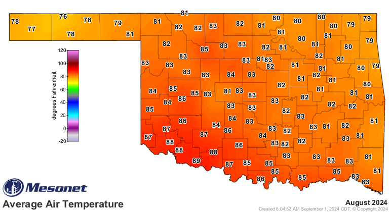
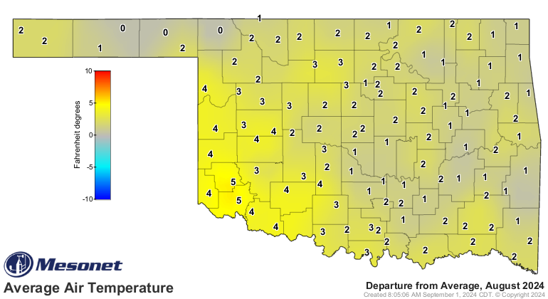
The statewide average temperature for August was 83 degrees, according to
preliminary data from the Mesonet, 2.2 degrees above normal, making it the
31st-warmest August since 1895. Statewide, temperatures ranged from a high of
113 degrees on Aug. 23 and 24 at several locations to a low of 49 degrees at
Eva on the month’s final day. The heat index reached a stifling 123 degrees on
Aug. 18 at Okmulgee, with 15 other sites exceeding 115 degrees. Mesonet sites
recorded heat index values of 110 degrees or higher 464 times during the month.
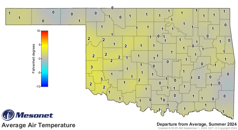
The summer average temperature was 81.6 degrees—1.6 degrees above normal—ranking
as the 21st-warmest on record. The first eight months of the year were the
sixth-warmest since 1895, with an average temperature of 64.6 degrees, 2
degrees above normal.

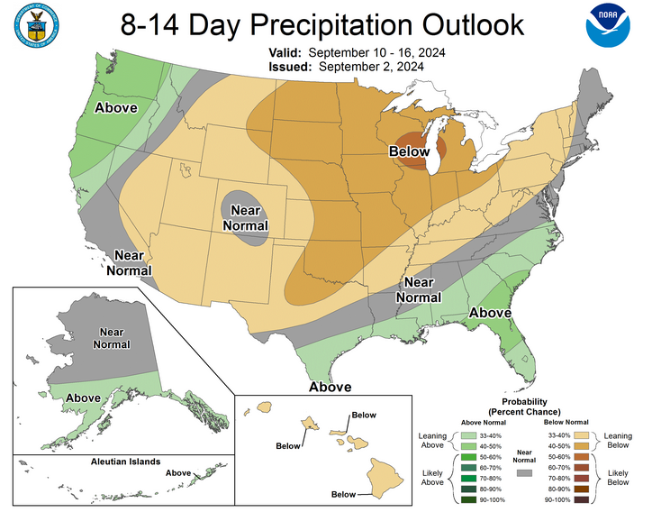
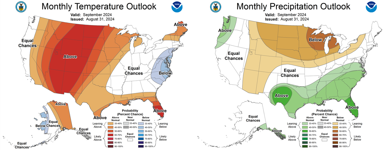
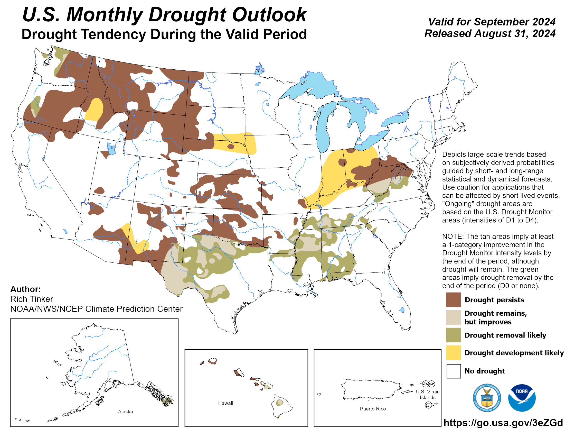
The September outlook from the Climate Prediction Center offers some hope for
parched areas in far southern Oklahoma. The temperature outlook predicts
above-normal temperatures across most of the state, with higher odds in the far
northwest, while the southeastern corner is expected to experience more typical
conditions. The rainfall outlook show equal chances for above-, below-, or
near-normal rainfall, except in far southern Oklahoma, where there are
increased odds for above-normal precipitation. As a result, the CPC’s September
Drought Outlook indicates potential drought improvement along the Red River,
while drought conditions are expected to persist in other parts of the state.
###
Gary McManus
State Climatologist
Oklahoma Mesonet
Oklahoma Climate Survey
gmcmanus@ou.edu
September 3 in Mesonet History
| Record | Value | Station | Year |
|---|---|---|---|
| Maximum Temperature | 111°F | ARDM | 2000 |
| Minimum Temperature | 44°F | KENT | 2010 |
| Maximum Rainfall | 3.51 inches | COOK | 2008 |
Mesonet records begin in 1994.
Search by Date
If you're a bit off, don't worry, because just like horseshoes, “almost” counts on the Ticker website!