Ticker for August 2, 2012
MESONET TICKER ... MESONET TICKER ... MESONET TICKER ... MESONET TICKER ...
August 2, 2012 August 2, 2012 August 2, 2012 August 2, 2012
Drought goes plaid, and yesterday was the 10th warmest day in OK history
I'll start with the bad news and then go onto the bad news.
Drought
With the state continuing to burn, literally AND figuratively, we asked for and
received a general degradation of the drought intensity across Oklahoma. Using
indicators such as soil moisture, pasture conditions, crop reports from the
field and the extreme temperatures, the U.S. Drought Monitor painted 72%
of the state in the extreme/exceptional drought category, a jump of 21% from
last week alone, and a jump of 69% from the beginning of May.
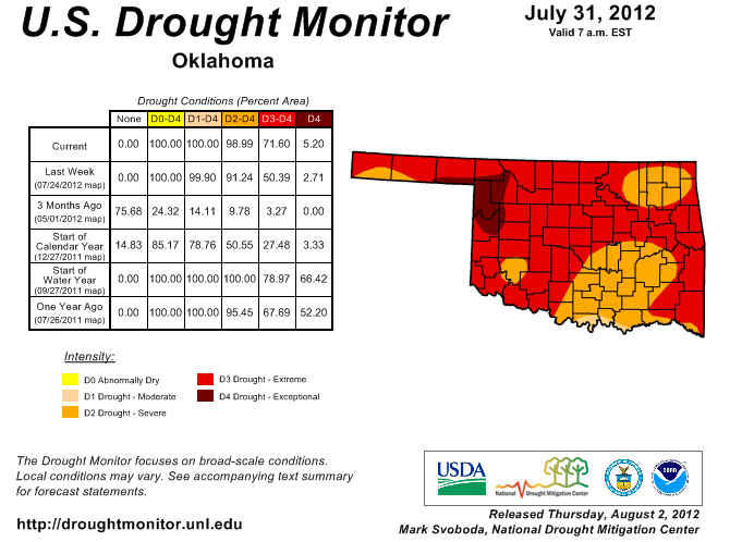
That's the highest percentage of the D3/D4 categories since Nov. 8, 2011, so
we are definitely backsliding towards the drought's zenith of about 10 months
ago, but luckily we still have a ways to go (and lots of time to improve). The
worst picture from the 2010-12 drought came on October 4, 2011, with 70% of the
state covered by exceptional drought.
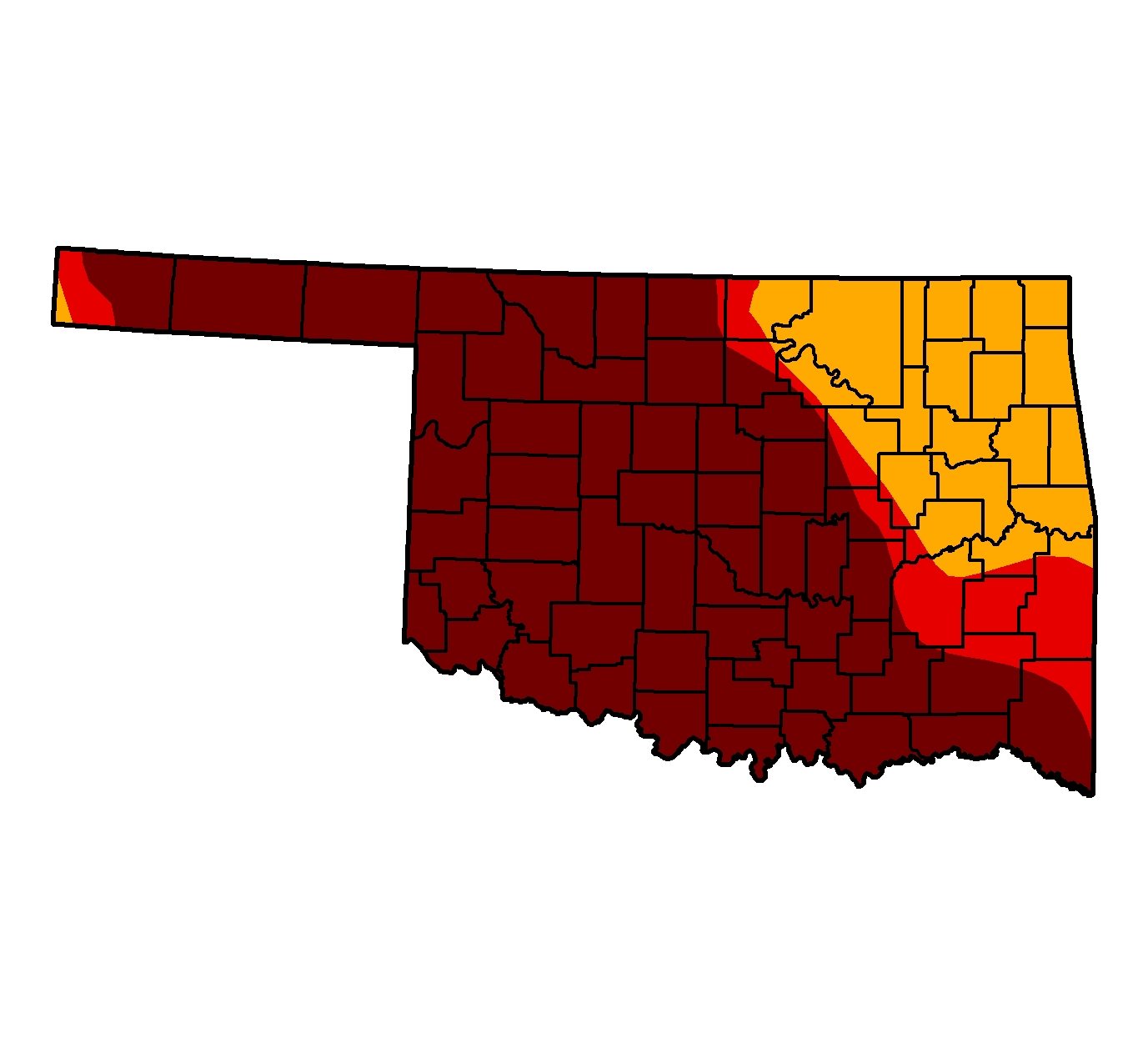
We continue with 96% of the state's topsoils in the poor/very poor category,
according to the USDA's NASS. However, we did have the "very short" category
jump from 62% to 71%. The other 4% of the soils are considered to have "adequate"
moisture. The subsoils are equally as bad at 96% considered short/very short,
and the remaining 4% in the adequate category. As you can tell from the map
below, however, we are not alone in our misery.
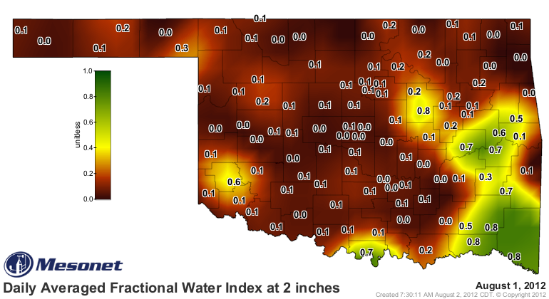
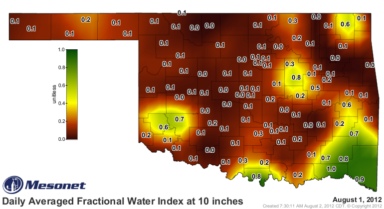
That is also backed up by the Oklahoma Mesonet's own soil moisture data.

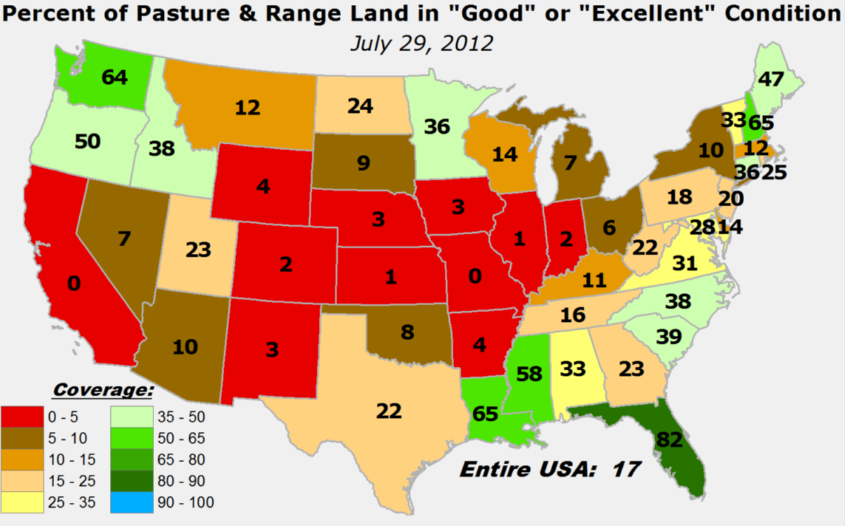
The same conditions are beginning to crop up with our pasture/rangelands. The
lastest from the USDA shows only 8% of Oklahoma's are considered to be in good/
excellent condition.
64% of the pastures are considered to be in poor/very poor condition.
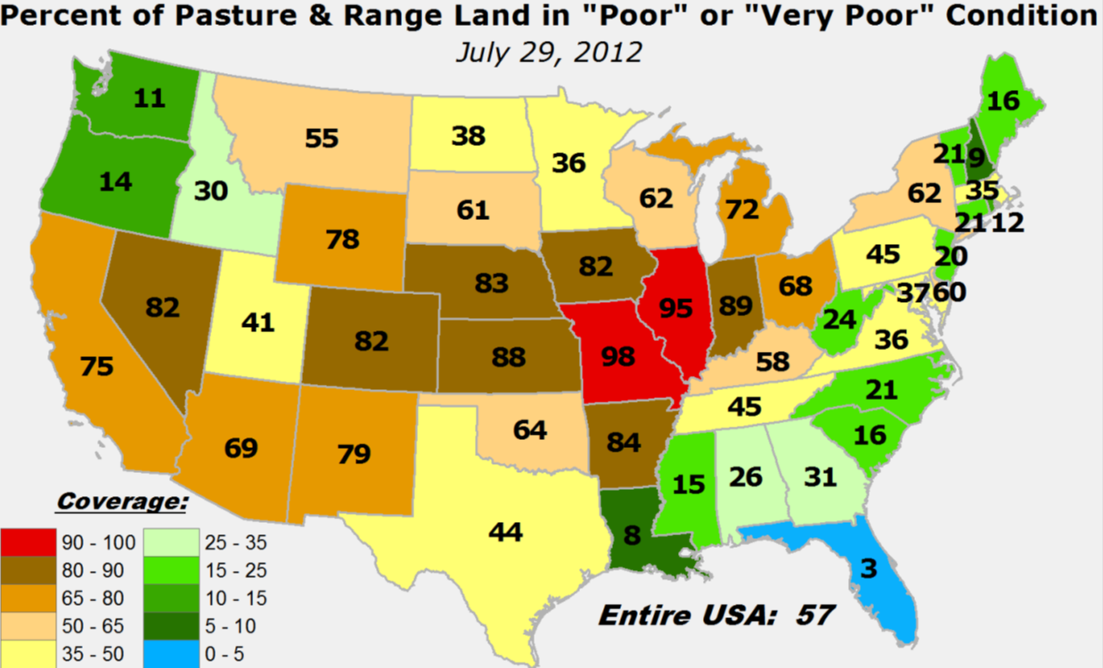
But, it's now August. Somewhat poor pasture conditions could normally be expected
at this time of the year. That's what happens as summer trudges along, we dry
out, turn yellow-ish/brown and await the fall rains. However, look at our
conditions relative to normal (for this time of the year) and we are still
obviously much worse off than what we would expect. The conditions now are worse
than 90% of the previous late Julys since 1995.
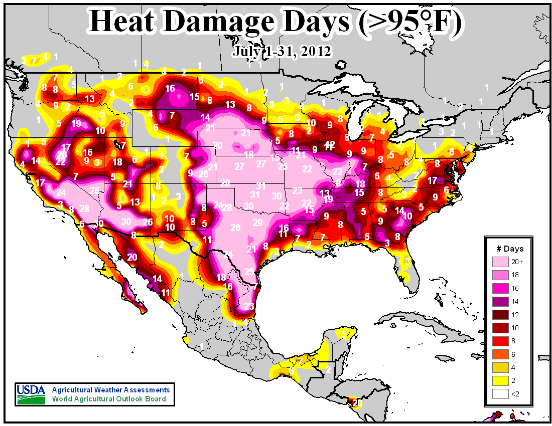
This map from the USDA sort of sums it up...the "heat damage days" accumulate
when temperatures reach 95 degrees or above for a day. This map is for July, and
Oklahoma pegged the meter. We're #1 again, unfortunately. This map uses 95 degrees
since that's the temperature level at which damage starts to occur to
reproductive wheat, and to some extent corn.
--------------------------------------------------------------------------------
Looking ahead
The latest U.S. Seasonal Drought Outlook is doom-and-gloom through October, but
I think in reality this map should really only be valid through August. There
is no indication just yet as to any diminishing of our secondary fall rainy
season as we get into September so we'll continue to hope for the best there.
But this map is pretty ugly nonetheless.
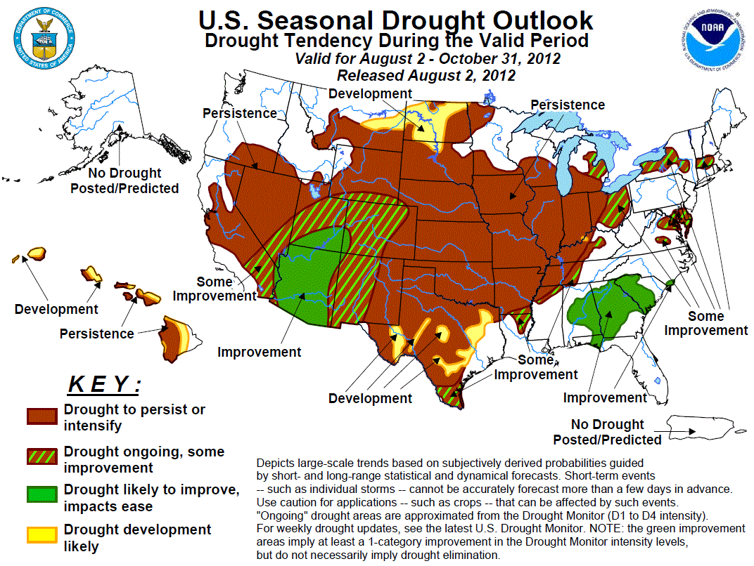
Their reasoning:
"Climatologically, the northern and southern Plains reach their normal
wet time of the year during the late spring and early summer, so by
the fall their precipitation is usually waning. Unfortunately, all
indicators (short and medium-term, August, and August-October) favor
above normal temperatures. With much of the Plains already in drought
and getting worse, above normal temperatures expected into the fall,
and a dry short-term and 30-day forecast, the drought should persist,
with some possible development in the northern Plains."
This is not a surprise at all. As I said, we will have to wait awhile to get
relief, probably. A slowdown of the heat would definitely help matters, but
that dry, parched ground will sit and wait once again for the heat dome to
return, should it decide to wander away.
At any rate, look for the drought to continue until we get into more favorable
conditions with both the heat and rainfall. Climatologically speaking, we're
talking September.
--------------------------------------------------------------------------------
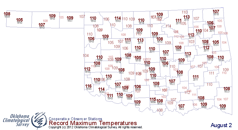
August 1 heat factoids
* The 115 degrees readings we saw yesterday at the Kingfisher Mesonet site and
the Enid airport (those are the ones we saw thus far...could be more COOP reports
out there floating around) are the highest readings ever recorded in Oklahoma on
August 1. Previous statewide highs for the data were the 113s at Ralston last
year and Meeker back in 1896.
* The 115s matched the highest highs from last year as well, back from June 26,
2011 and August 3, 2011.
* Yesterday was tied for 10th warmest day (based on statewide average, highs and
lows) on record for the state at 93.7 degrees. Tied with August 3, 2011, and
August 12, 1934.
* The 75 Mesonet stations that hit 110 degrees or higher was the second highest
since Mesonet temperatures began in 1997. First place is still August 2, 2011,
with 87. That day last year is also the 5th warmest day on record at 93.9 degrees.
* We haven't hit 116 degrees or higher in the state since June 3 and 4, 2002,
when we did indeed hit 116. We haven't been above 116 in the state since
September 1, 1985, when McGee Creek Dam hit 118 degrees. Mangum hit 117 degrees
four times in the summer of 1980.
* Tulsa tied its all-time record high minimum temperature with a low of 88
degrees, yesterday. They had previously set this new mark back on July 30 of
this year. Previous highest minimum temperature was 87 degrees from two dates
in August.
* Oklahoma City and Tulsa both reached 112 degrees yesterday, breaking their
daily high temperature records. The 112 degrees at OKC was the second hottest
temperature ever measured there. The last time the high temperature reached 112
degrees was on august 10, 1936. The all time hottest temperature in OKC is
113 degrees from August 11, 1936. Tulsa's highest temperature ever recorded
is 115 degrees from August 10, 1936.
Here are the temperature records to shoot for today. Hollis' 116 degrees from
1944 is the day's top temperature ever. That one looks to be in jeopardy today.
--------------------------------------------------------------------------------
August 2 in Mesonet History
| Record | Value | Station | Year |
|---|---|---|---|
| Maximum Temperature | 114°F | KIN2 | 2012 |
| Minimum Temperature | 51°F | BURB | 2009 |
| Maximum Rainfall | 6.63 inches | HOLL | 1995 |
Mesonet records begin in 1994.
Search by Date
If you're a bit off, don't worry, because just like horseshoes, “almost” counts on the Ticker website!