Ticker for December 1, 2020
MESONET TICKER ... MESONET TICKER ... MESONET TICKER ... MESONET TICKER ...
December 1, 2020 December 1, 2020 December 1, 2020 December 1, 2020
Snowtastrophe!
Hey, this isn't the snowstorm the winter-philes ordered, but at least for the
folks across NW OK, it will do. And it is a serious situation, what with maybe
around a half-day where folks will be stuck at home. Do you know what can
happen in half a day, stuck at home with nowhere to go? NO? Well where have you
been for the last 9 months? All kidding aside, extra caution will be
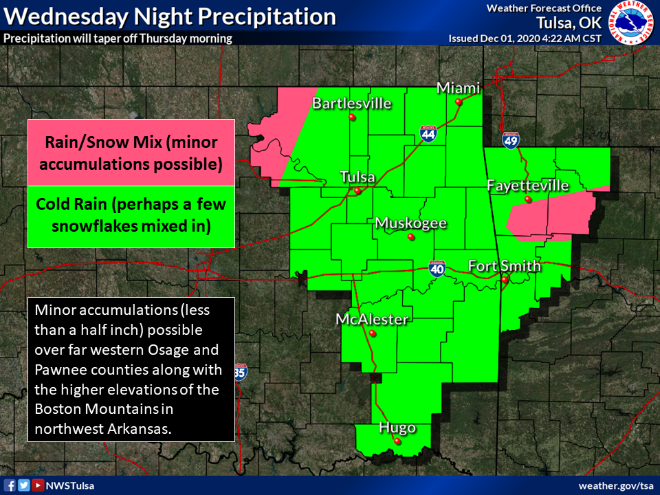
needed on area roads that day due to possible slick conditions. For the rest of
us (NO...NOT FESTIVUS!), the dreaded rain-snow mix or just a plain cold rain.
(Rain-snow mix...the Hawkeye of winter weather types.)
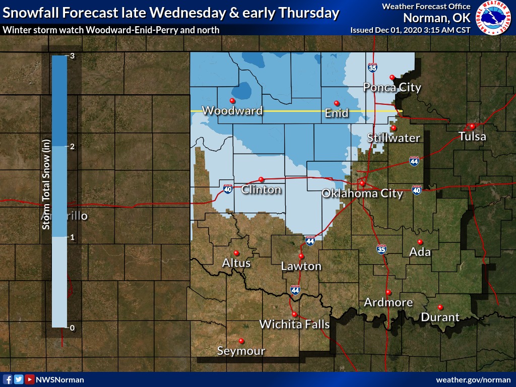
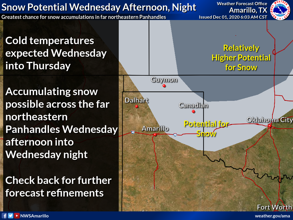
There has been lots of discussion about heavier bands of snow contained within
this larger area, and those bands could dump 5-6 inches in localized areas,
as discussed in a winter storm watch issued by our friends at the NWS Norman
office:
"As a cold storm system moves over the region Wednesday into
Thursday, rain is expected to change over to snow. The heaviest
snow is expected to occur over northern Oklahoma, where
accumulations will be high enough to create travel disruptions.
* WHAT...Heavy snow possible. Total snow accumulations of 3 to 5
inches may occur under heavier snow bands.
* WHERE...Far northern Oklahoma.
* WHEN...From Wednesday afternoon through Thursday morning.
* IMPACTS...Plan on slippery road conditions. The hazardous
conditions could impact the morning or evening commute.
One small correction, Okies up that way don't "commute," they just get in
their vehicles and drive where they need to. Commuting is for city slickers.
Whatever form the moisture falls in, it is very much needed across the state,
as you'll see below in our November summary.
It ain't much, but it's a start. Of course, after talking about all this snow,
we need to remind you that the event is still at least a day away, and more
refinements are needed...both in Ticker writers AND forecasts.
Now sit right back and we'll tell a tale, a tale of a fateful trip. To November.
The trip is back to November. It won't take 3 hours, but it will seem like
that's how much time you wasted when you're finished.
-------------------------------------------------------------------------------
November Sees More Drought, Tornadoes
Dec. 1, 2020
November’s weather struggled to live up to the level of excitement provided by
October’s historic cold snap and ice storm, although it had its moments.
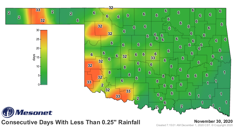
Following that burst of moisture just before Halloween, some areas of the state
went more than a month without seeing at least a quarter inch of rain in a
single day.
Other areas saw Oklahoma’s weather at its worst, however. Storms on the 24th
brought severe weather back to the state with damaging winds and hail up to the
size of golf balls. At least two tornadoes touched down that day in southeastern
Oklahoma. The first struck near Kinta in Haskell County around 9 p.m.,
destroying a mobile home and damaging other structures. The second came about
an hour later near Spiro in Le Flore County and damaged a barn.
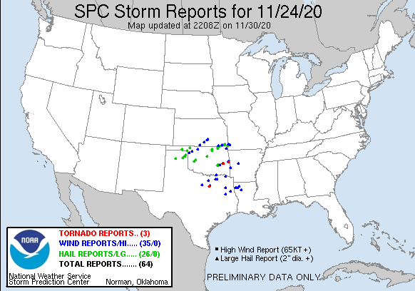
The November tornadoes brought the unofficial 2020 total to 39 according to
preliminary data from the National Weather Service, well below the 1951-2019
annual average of 57.4, and dwarfed by 2019’s record total of 149. This year’s
tally would also mark the state’s lowest since 2009’s 34 confirmed twisters.
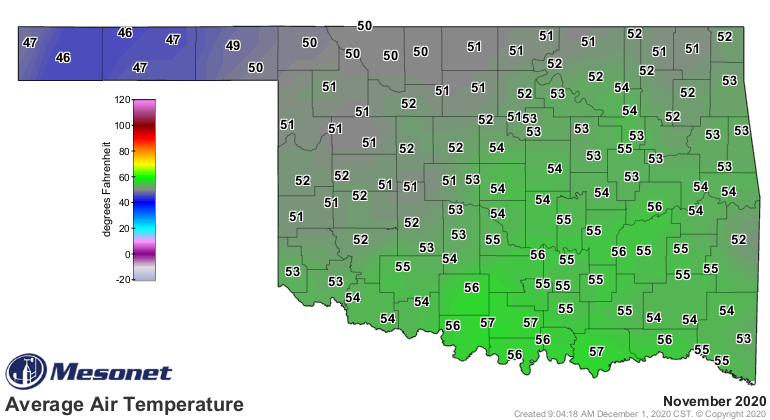
According to preliminary data from the Oklahoma Mesonet, the statewide average
temperature was 53 degrees to rank as the 10th warmest November since records
began in 1895, 3.7 degrees above normal. November was also the first month
since June to finish warmer than normal statewide. The month’s lowest reading
of 12 degrees – also the lowest for the season thus far – was reported at
Hooker on the 31st. The Mesonet recorded a slew of 70s and 80s during the month,
including November’s highest reading of 86 degrees at both Arnett and Goodwell
on the 19th.
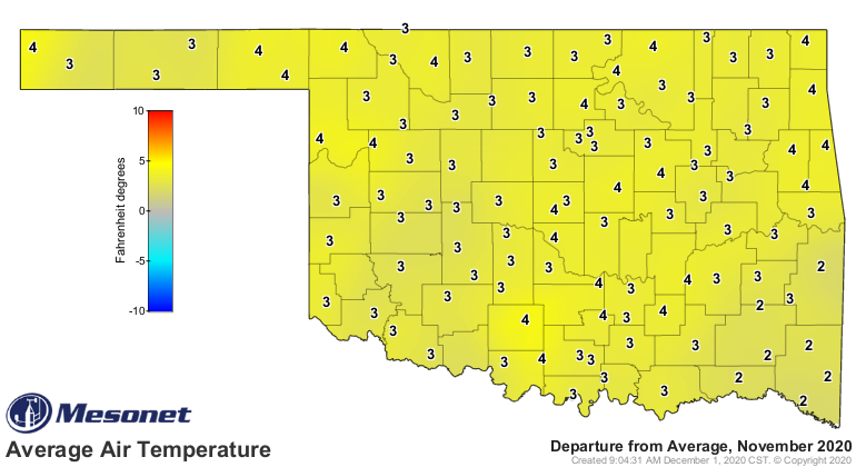
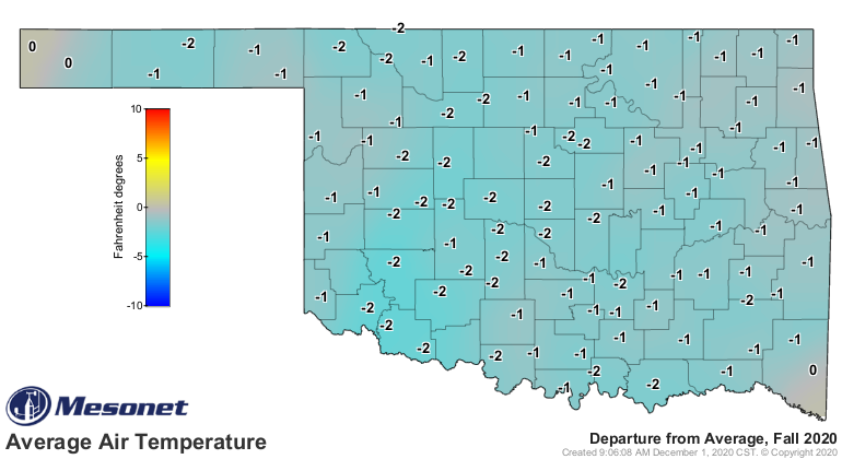
The warm November somewhat offset the cooler than normal September-October
period, but the climatological fall (September-November) still finished 0.6
degrees below normal with an average of 60.2 degrees, the 41st coolest autumn
on record.

The first 11 months of the year were the 35th warmest on record with a
statewide average of 62.4 degrees, 0.6 degrees above normal.
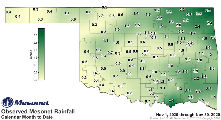
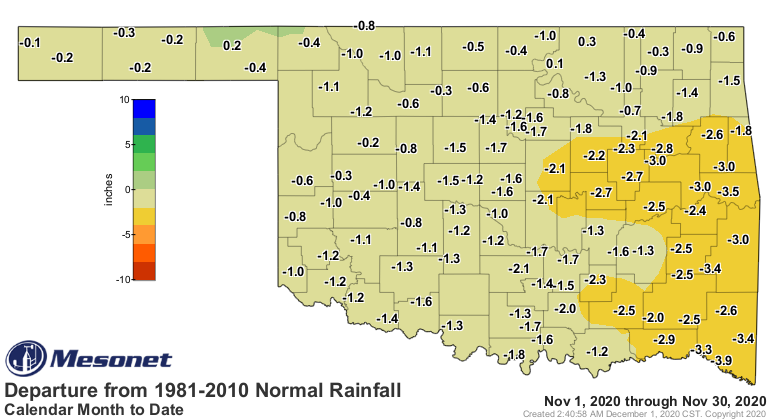
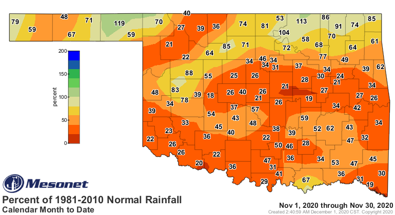
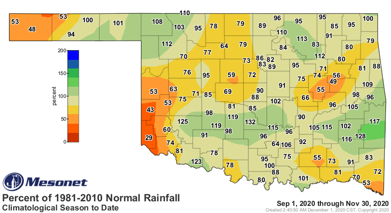
The statewide average precipitation total, as measured by the Mesonet, was 1.39
inches below normal at 1.12 inches. That ranks the month as the 37th driest
November on record. Only three of the Mesonet’s 120 sites finished with above
normal precipitation for November: Beaver, 1.08 inches; Burbank, 2.23 inches;
and Foraker at 2.63 inches. Miami actually led the state with 3.44 inches, but
that total still fell below their November normal of 4.13 inches. Arnett
brought up the rear with 0.24 inches, and 60 other Mesonet sites failed to
receive at least an inch for the month. Deficits were generally around an inch,
although areas of east central and southeastern Oklahoma fell 2-3 inches below
normal.
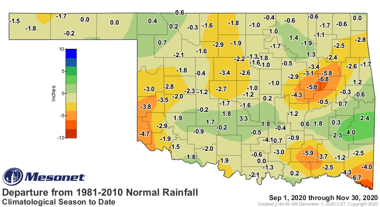
The fall average total of 8.6 inches was 0.98 inches below normal to rank as
the 59th wettest on record. Deficits of 4-6 inches were isolated in parts of
far southwestern, southeastern, and east central Oklahoma. Otherwise, amounts
were either close to or within 2-3 inches of normal.
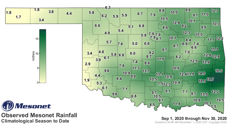
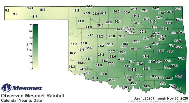
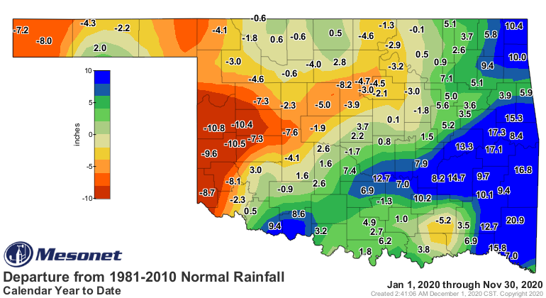
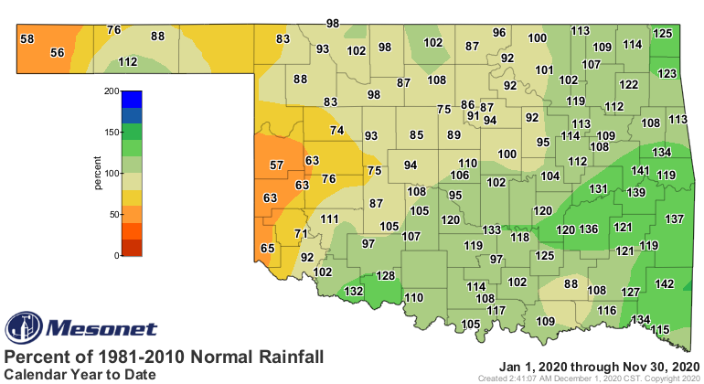
The first 11 months of the year finished 2.34 inches above normal at 36.78
inches across the state, the 27th wettest January-November on record. There was
a stark difference in moisture totals across the state, however, with deficits
of up to 11 inches for that period in the southwest to surpluses of nearly 18
inches in east central Oklahoma.
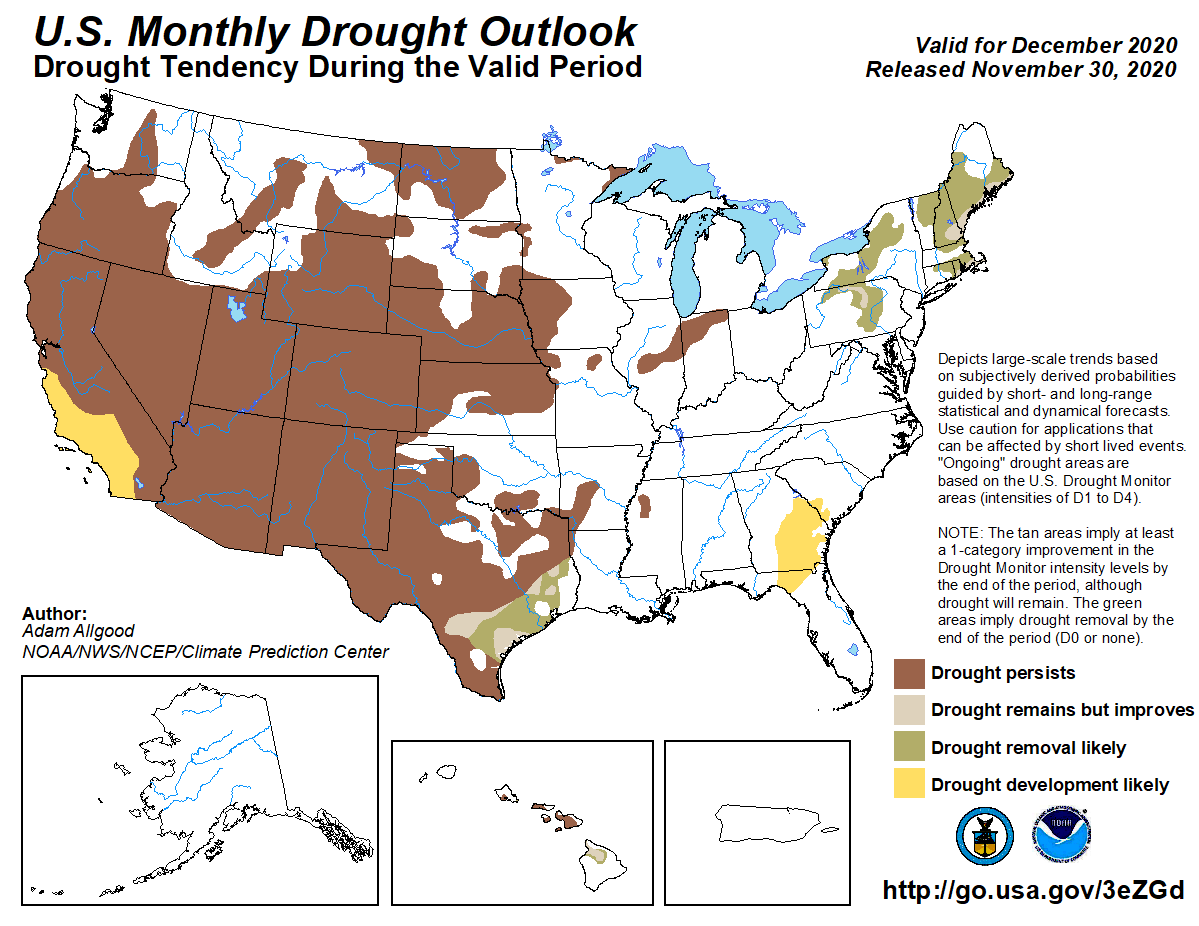
Drought coverage dropped from 34% of the state at the end of October to 11%
after the first two weeks of November. The prolonged dry weather resulted in
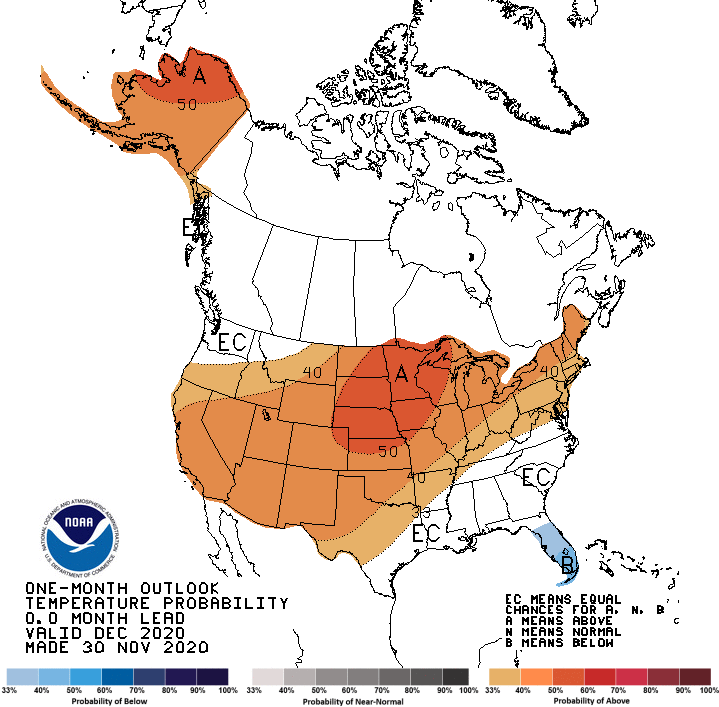
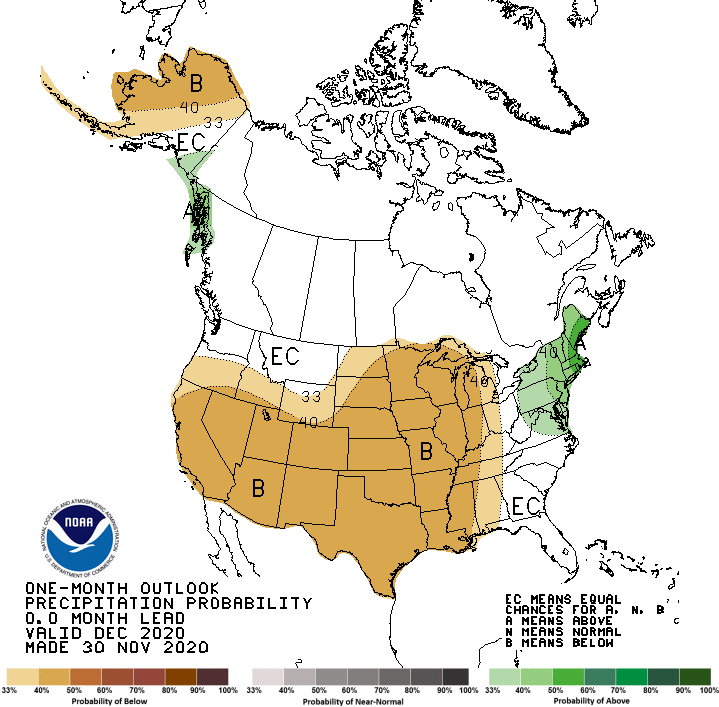
an increase to 25% coverage at the end of November. The December outlooks from
the Climate Prediction Center (CPC) indicate increased odds of above normal
temperatures and below normal precipitation across the entire state. Despite
those possible outcomes, CPC’s December drought outlook does not see further
drought development as likely during December.
Gary McManus
State Climatologist
Oklahoma Mesonet
Oklahoma Climatological Survey
(405) 325-2253
gmcmanus@mesonet.org
December 1 in Mesonet History
| Record | Value | Station | Year |
|---|---|---|---|
| Maximum Temperature | 86°F | HOLL | 2012 |
| Minimum Temperature | 0°F | SEIL | 2006 |
| Maximum Rainfall | 0.75″ | WATO | 2015 |
Mesonet records begin in 1994.
Search by Date
If you're a bit off, don't worry, because just like horseshoes, “almost” counts on the Ticker website!