Ticker for October 1, 2018
MESONET TICKER ... MESONET TICKER ... MESONET TICKER ... MESONET TICKER ...
October 1, 2018 October 1, 2018 October 1, 2018 October 1, 2018
Goodbye September!
Before we get to September's exciting summary (bigtime rain...other than that,
meh), looks like we might have a bit of a repeat of the previous month. Pretty
uneventful (but deliciously warm) weather coming up for this week before we
hit the moisture mother lode again over the weekend. We'll have rain chances
off and on through the week, but the big stuff hits this weekend, apparently.
And then Mother Nature pulls the rug out from under summer and yanks us right
into winter'ish mode next weekend, possibly.
That's all alleged, of course, depending on the placement and timing of the
large trough over the western U.S. vs. the ridge over the eastern U.S., with us
caught in the middle.
Either mayhem or harmony. Speaking of mayhem, how about those September rains
in southern Oklahoma!
Read on, MacDuff.
----------------------------------------------------------------------------------
September Sees Historic Rains
Many of Oklahoma’s most extreme rainfall events have occurred during the fall,
the result of a rare conjunction of meteorological ingredients converging over
the Southern Plains. Those ingredients – the remnants of a pacific tropical
system, a stalled front, and abundant moisture from the Gulf of Mexico – came
together late in the month to produce massive rainfall totals across south
central Oklahoma.

The Oklahoma Mesonet site at Fittstown recorded 14.2 inches of
rain on Sept. 21, the second-highest daily total observed in the state since
individual station records began in the 1880s, and the highest total in the
25-year history of the Mesonet. Enid remains in the top historical spot with
15.68 inches on Oct. 11, 1973, while the Mesonet’s previous record of 12.42
inches at Burneyville on April 29, 2009, was easily bested. There were numerous
unofficial and radar-estimated reports of 15-20 inches in the Pontotoc County
area during the storm. The rain totals represent a greater than 1,000-year
24-hour event according to the Oklahoma Conservation Commission and USDA-Natural
Resources Conservation Service. Widespread flooding was reported across the
southern half of the state, and the National Weather Service (NWS) issued a
flash flood emergency for Pontotoc County and the surrounding area.
Heavy rains during the first week combined with that later storm to produce a
statewide average total of 5.21 inches, a surplus of 1.68 inches, to rank as
the 19th wettest September since climate division records began in 1895.
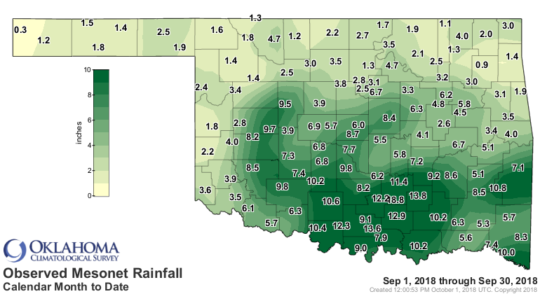
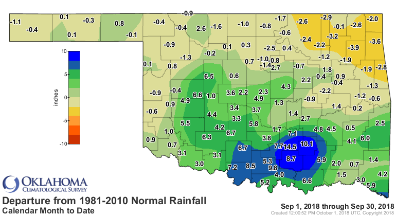

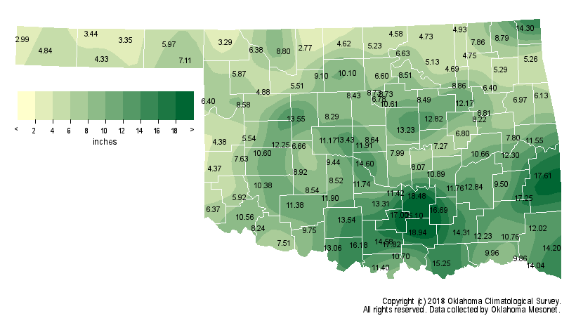
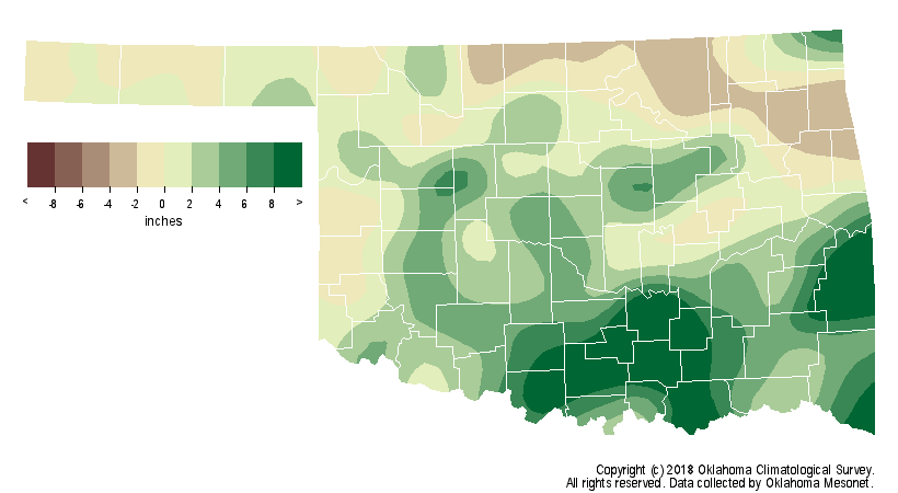
Much of southern Oklahoma received between 8-10 inches of rain, although the
far southwest struggled to reach 4 inches. South central Oklahoma’s average of
11.04 inches was 7.11 inches above normal, the wettest September on record for
that section of the state. The northern third of the state did not fare as well
with 1-2 inches commonly reported. The northeast corner’s average of 2.9 inches
was 1.6 inches below normal, 48th driest on record. Fifteen of the Mesonet’s
120 stations recorded at least 10 inches, led by Fittstown’s 18.75 inches, and
another 48 sites received at least 5 inches. The NWS cooperative observer at
Pontotoc reported 20.89 inches for the month. Kenton had the lowest total at
0.26 inches. Statewide, August and September combined to produce the eighth
wettest such period on record at 9.21 inches, 2.63 inches above normal.
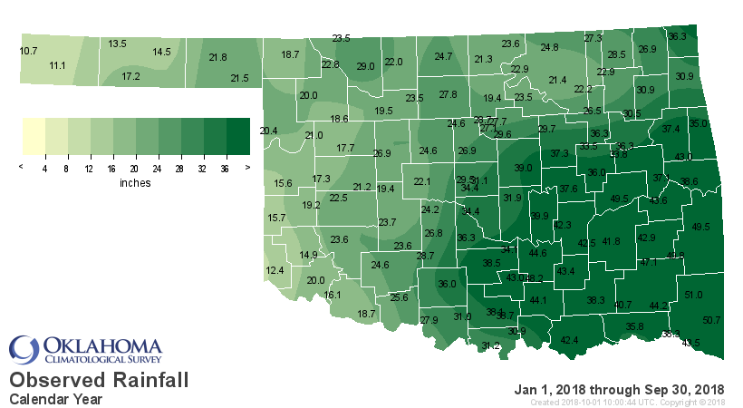
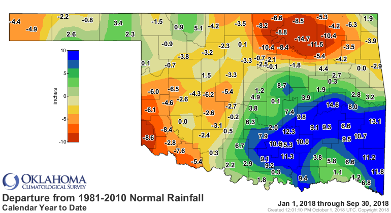
The average for the first nine months of the year rose to 29.15 inches, 0.76
inches above normal to rank as the 40th wettest January-September on record.

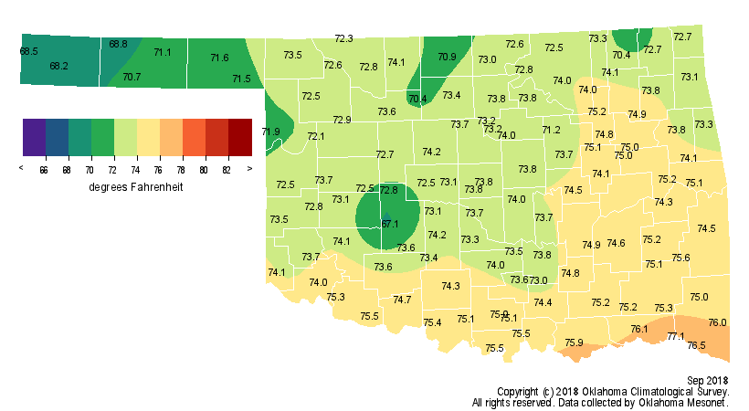
The Mesonet’s 120 sites recorded only five triple-digit temperatures during
September, versus 10 readings in the 30s. The state’s highest temperature of
100 degrees was observed at five different locations, the last at Talihina on
the 19th. Barring a rare triple-digit temperature during the final three months,
that was undoubtedly 2018’s last such occurrence. The Eva Mesonet site recorded
the lowest September temperature of 36 degrees on the 22nd. Despite the lack of
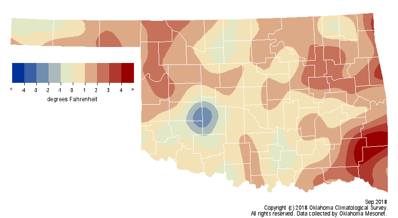
extreme heat, the statewide average temperature still managed to finish 1.1
degrees above normal to rank as the 59th warmest September on record.
The positive temperature anomaly was due mainly to September’s minimum
temperatures, which were nearly 4 degrees above normal.
Drought took a large step back for the second consecutive month. Drought
coverage dropped from 55 percent of the state at the beginning of August to 9
percent at the end of September. Only two small core areas of drought
remained – across far southwestern Oklahoma and a smaller area centered on
eastern Osage and southern Washington counties.

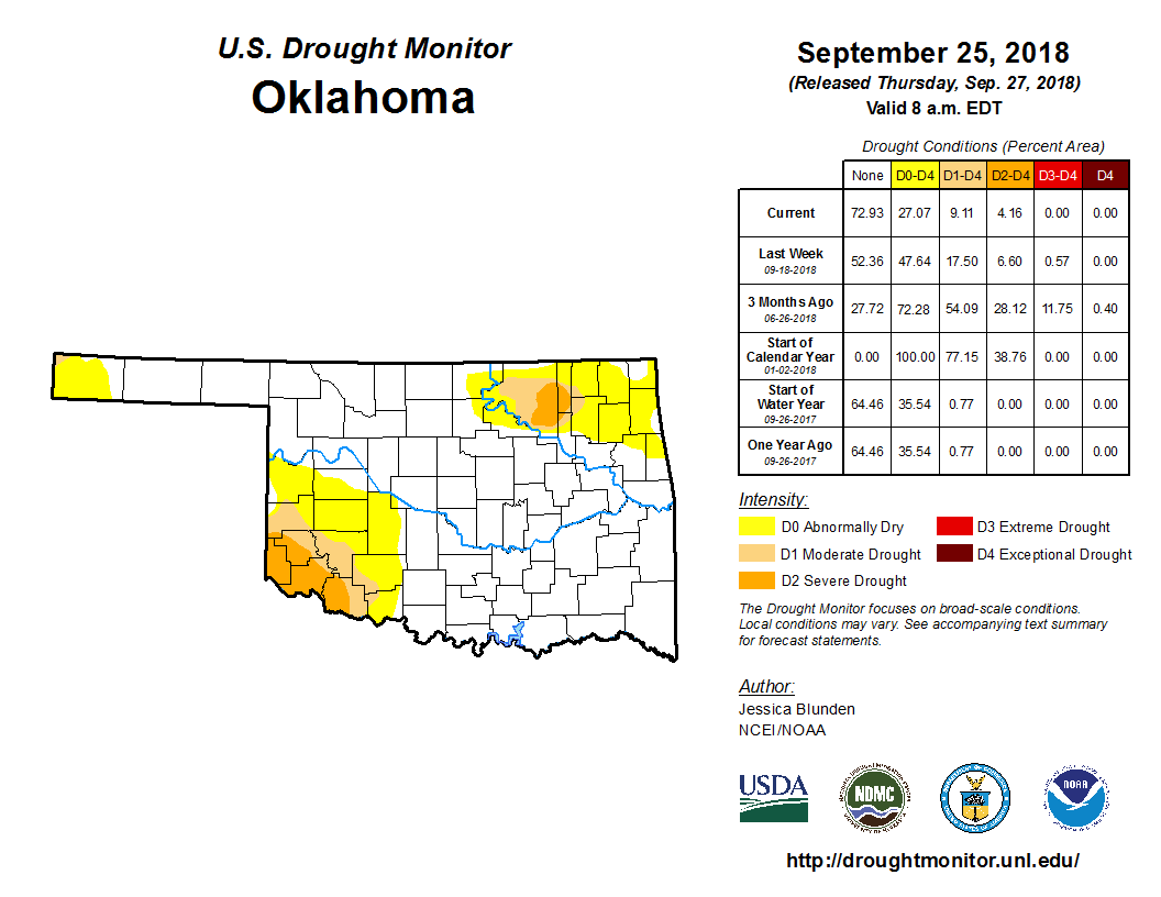
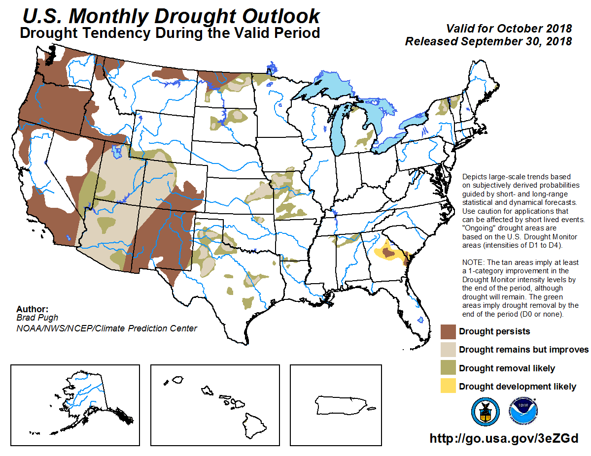
The October outlooks from the Climate Prediction Center (CPC) indicate
increased odds of above normal temperatures across the entire state, but
especially eastern Oklahoma, and above normal precipitation. Given those
outlooks, CPC’s October Drought Outlook sees improvement across the remaining
drought areas in Oklahoma by the end of October.
Gary McManus
State Climatologist
Oklahoma Mesonet
Oklahoma Climatological Survey
(405) 325-2253
gmcmanus@mesonet.org
October 1 in Mesonet History
| Record | Value | Station | Year |
|---|---|---|---|
| Maximum Temperature | 99°F | SLAP | 2000 |
| Minimum Temperature | 34°F | KENT | 2009 |
| Maximum Rainfall | 3.52 inches | ERIC | 1998 |
Mesonet records begin in 1994.
Search by Date
If you're a bit off, don't worry, because just like horseshoes, “almost” counts on the Ticker website!