Ticker for October 1, 2012
MESONET TICKER ... MESONET TICKER ... MESONET TICKER ... MESONET TICKER ...
October 1, 2012 October 1, 2012 October 1, 2012 October 1, 2012
Late September Rains Provide Drought Relief
Hopes for drought relief were starting to fade as September wound down, only to be
saved by a slow-moving soaker of a storm system during the month?s last week. The
storm system?s prodigious moisture output was aided by a stationary front and in
part by the remnants of Hurricane Miriam, spawned in the Pacific Ocean during the
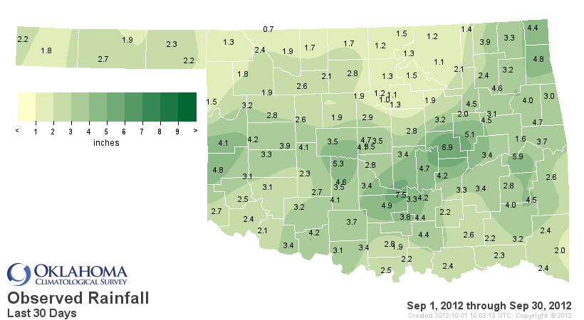
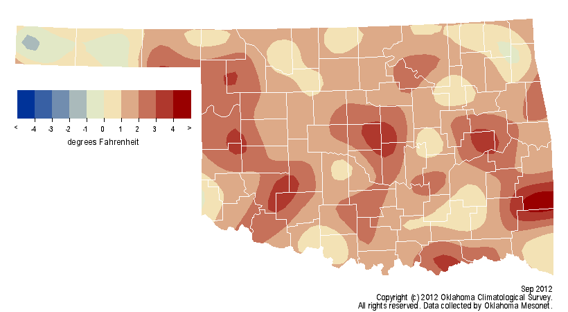
previous week. Totals of 2-4 inches were widespread across central and southern
Oklahoma according to the Oklahoma Mesonet, mainly south of Interstate 40. The
Mesonet site at Byars in Garvin County recorded 6.02 inches during the event.
Unfortunately, not everybody shared in the drought-relieving moisture. Totals of
less than an inch were common across the northern third of the state. Despite the
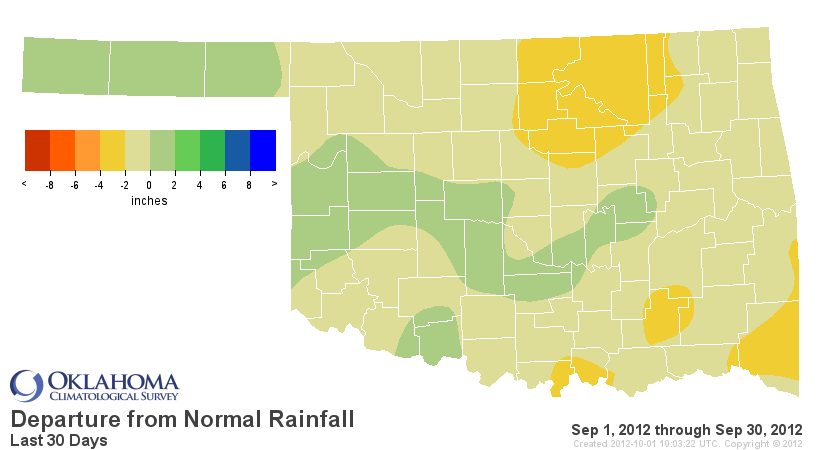
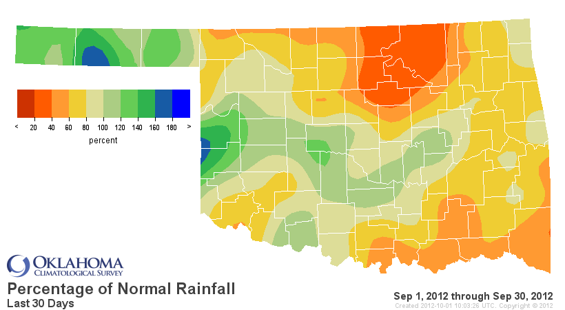
attempted recovery at the end, September still finished nearly an inch below
normal with a statewide average of 2.9 inches according to data from the Oklahoma
Mesonet. The Mesonet site at May Ranch in Woods County had the lowest total with
0.74 inches during September while Byars in Garvin County led the state with 7.5
inches. When compared to normal, much of eastern and northern Oklahoma had
deficits of 1-3 inches during September. The statewide average deficit for May-
September climbed to more than 8 inches and ranked as one of the five driest
such stretches on record, dating back to 1895.
Southern Plains rainfall
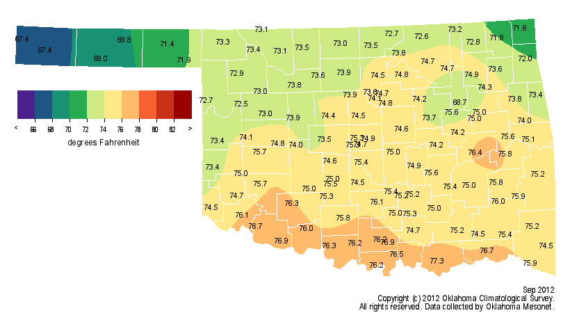
The month was also on the warm side with an average temperature of 74.1 degrees,
1.7 degrees above normal. That ranks as the 36th warmest September on record.
The highest temperature of the month, 111 degrees, came from the National
Weather Service (NWS) site at Ralston on Sept. 4 and the lowest reading was a
frigid 37 degrees recorded at Boise City and Kenton on Sept. 15 and 16,
respectively. Oklahoma remains on course for its warmest year on record with a
January-September statewide average temperature of 66.9 degrees, 4 degrees
above normal. That bests the previous record of 66.3 degrees for the first nine
months of the year from 1954 and keeps that year?s record annual mark of 62.8
degrees within reach. September became the 25th month out of the last 30 to
finish warmer than normal, a streak that began with April 2010.
Severe weather was a bit more widespread during September after a benign August,
although tornadoes remained absent. According to preliminary data from the NWS,
no tornadoes have touched down in Oklahoma since June 1. That?s a record low
total matched only by a similar June-September shutout in 2003. Accurate
tornado statistics data back to 1950. Several instances of wind gusting to over
70 mph were reported during the month, including an 80 mph gust near Crowder on
Sept. 26.
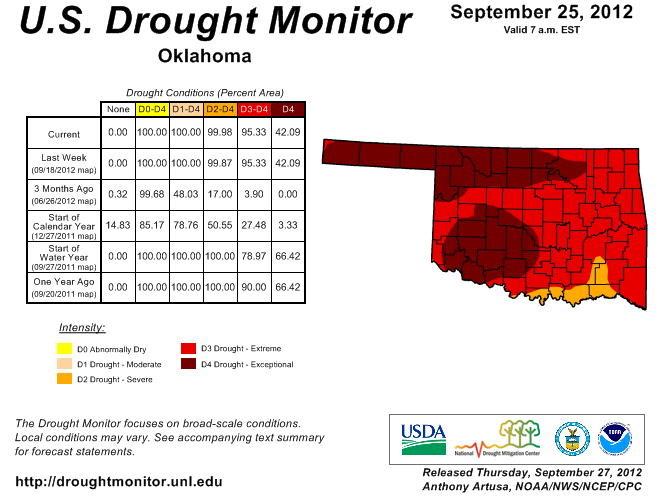
September ended with more than 42 percent of the state covered by exceptional
drought in the latest U.S. Drought Monitor map. Exceptional drought is the worst
such designation possible. More than 95 percent of Oklahoma was in the worst
two drought categories, extreme and exceptional, and 100 percent remained in
severe-to-exceptional drought. That will undoubtedly change once the rains of
late September are factored into the next Drought Monitor map, scheduled to be
released on Oct. 4. Most, if not all, of Oklahoma will still be covered by
drought of some intensity, however.
Other than a few showers, very little is expected in the way of rainfall over
the next several days according to NWS forecasts. There will be a greater
chance of rain over the weekend with the arrival of a cold front that is
expected to bring some of the coolest air of the season to Oklahoma. The
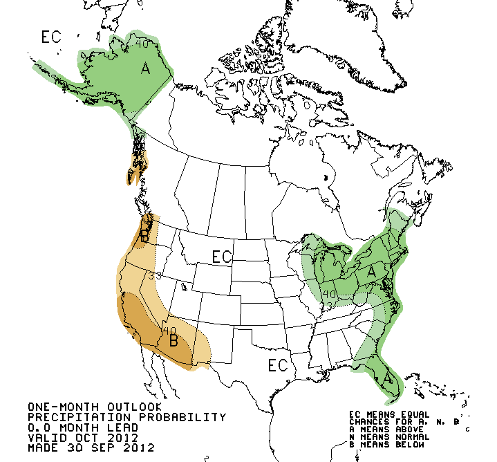
October temperature and precipitation outlooks from the NWS? Climate Prediction
Center hold few clues on what to expect for the next month. Most of the state
is given equal chances for above-, below- or near-normal rainfall and
temperatures, although the eastern half of the state is given slightly
increased odds for cooler than normal weather. That?s similar to the winter
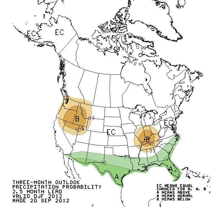
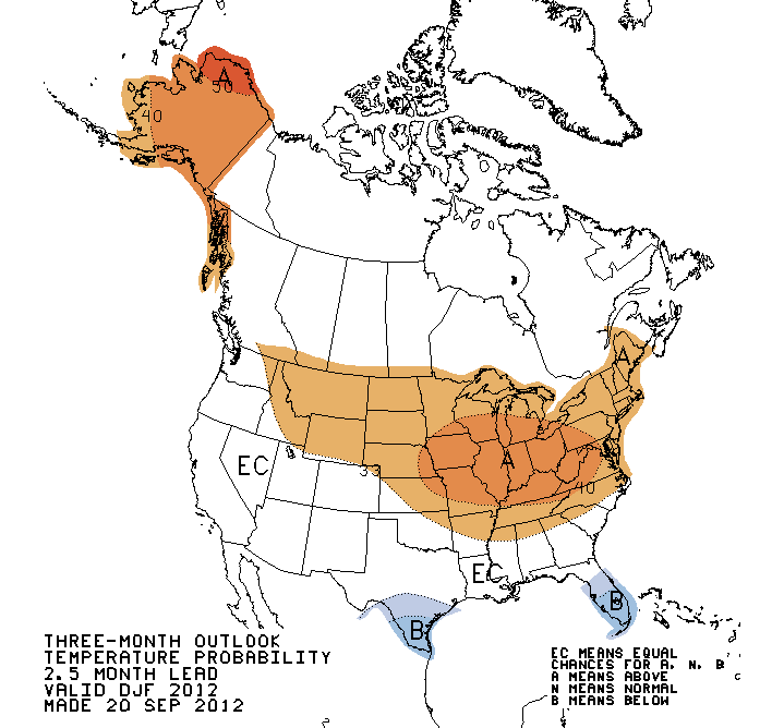
outlook (December 2012 ?February 2013) from the CPC, except for slightly
increased odds of above normal temperatures across northeastern Oklahoma.
October CPC Outlooks
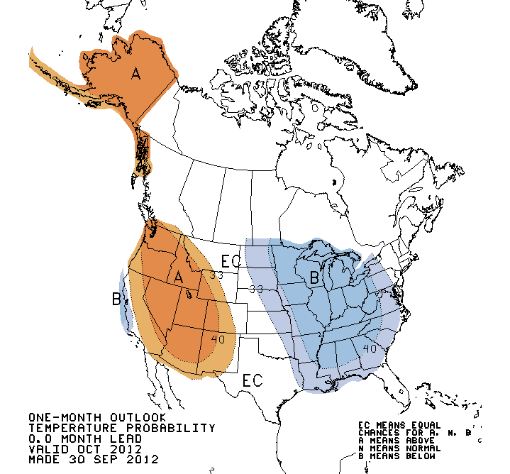
Dec 2012-Feb 2013 CPC Outlooks
Gary McManus
Associate State Climatologist
Oklahoma Climatological Survey
(405) 325-2253
gmcmanus@mesonet.org
October 1 in Mesonet History
| Record | Value | Station | Year |
|---|---|---|---|
| Maximum Temperature | 99°F | SLAP | 2000 |
| Minimum Temperature | 34°F | KENT | 2009 |
| Maximum Rainfall | 3.52 inches | ERIC | 1998 |
Mesonet records begin in 1994.
Search by Date
If you're a bit off, don't worry, because just like horseshoes, “almost” counts on the Ticker website!