Ticker for September 1, 2020
MESONET TICKER ... MESONET TICKER ... MESONET TICKER ... MESONET TICKER ...
September 1, 2020 September 1, 2020 September 1, 2020 September 1, 2020
Crcofall Dundee
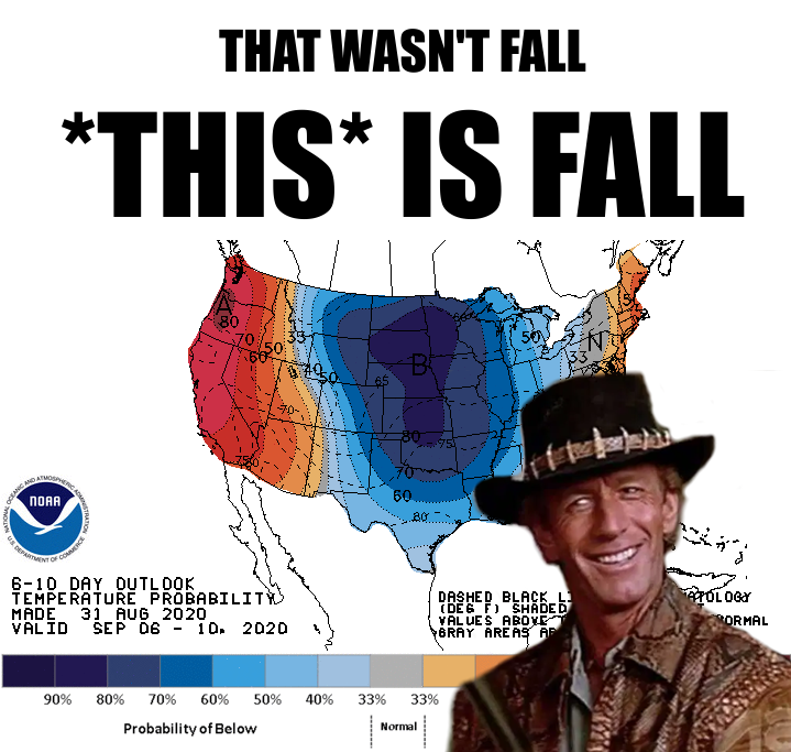
Now you might be saying to yourself "but Gary, you said fall was this week." First
off, if your name isn't Gary, that's an odd thing to say to yourself. Thirdly
(second is first loser), I did say it was sort of fake fall this week. But
NEXT week, that's when FALL fall arrives. You like highs in the 60s and lows in
the 40s? Okay, first you call yourself by my name in your head, now I hear you
like cold weather. Seek help! Here's a sampler of just a bit of forecast model
output showing the *POSSIBLE* weather pattern change for next week.
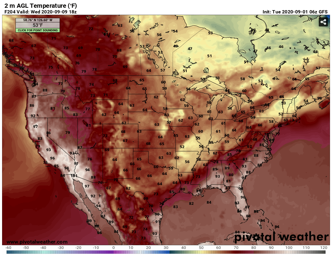
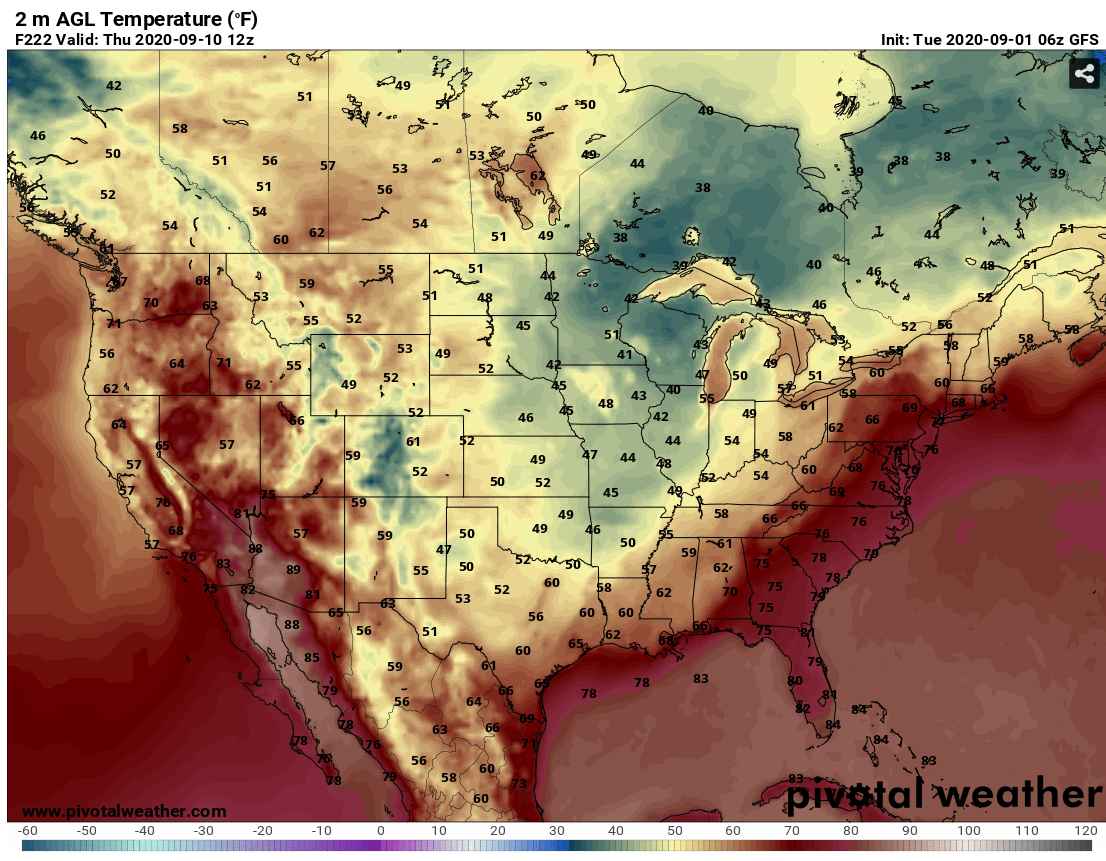
Again, *POSSIBLE* weather pattern change. Still a good week or so to go for
Mother Nature to gum up the works, but it is that time of year when these things
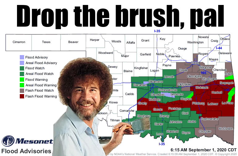
start to happen a bit more frequently. Hopefully we'll see eastern Oklahoma dry
out by then, and western Oklahoma get a bit more rain. There are still substantial
chances for more moisture this week, but some folks are throwing up a soggy white
flag. Others, like in Alva, are saying "what rain?" Chances aren't as great up
across NW OK.
As you'll see in the August monthly summary below, much of the state remained
below normal when it came to precip over the last month. If we can lower those
high temperatures down 20-30 degrees, that will take a lot of pressure off
the soil moisture, at least.
Speaking of August, let's take a look back at a cool, mostly dry month, and look
forward to September...another who knows what month.
-------------------------------------------------------------------------------
Cold Fronts Tame August Heat
Sept. 1, 2020
Three strong cold fronts brought the summer heat to its knees during August,
but drought took advantage of a mostly dry month to proliferate across western
Oklahoma. The far southeast was anything but parched, however, after several
rounds of heavy precipitation and a brush with the outskirts of Hurricane Laura
left it with nearly a foot of rain for the month. There were sporadic outbursts
of severe weather during August. Straight line winds of 70 mph and greater were
suspected in the derailment of 16 train cars in Ellis County on August 10, and
the Oklahoma Mesonet site at Burneyville recorded a wind gust of 80 mph on the
16th. Mother Nature saved the most exciting weather for last, though, with a
strong cold front on August’s final day. The front kicked off several rounds of
storms that brought widespread severe weather and flooding. Numerous water
rescues of stranded motorists were reported with flash flooding across central
and southeastern Oklahoma, and hail to the size of golf balls fell with many of
the storms.
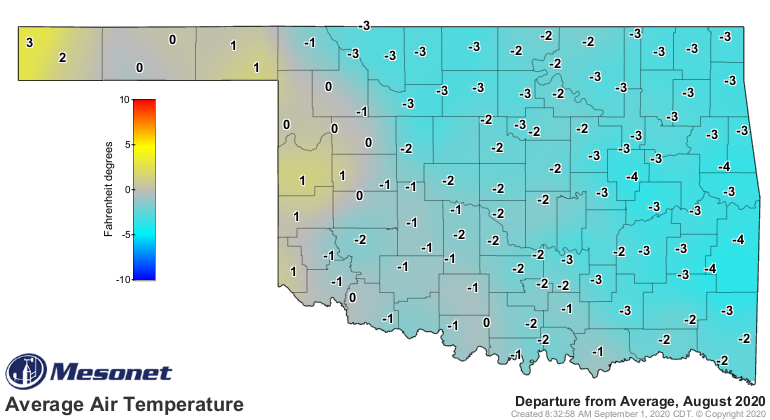
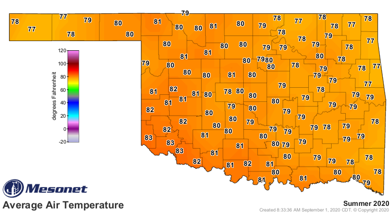
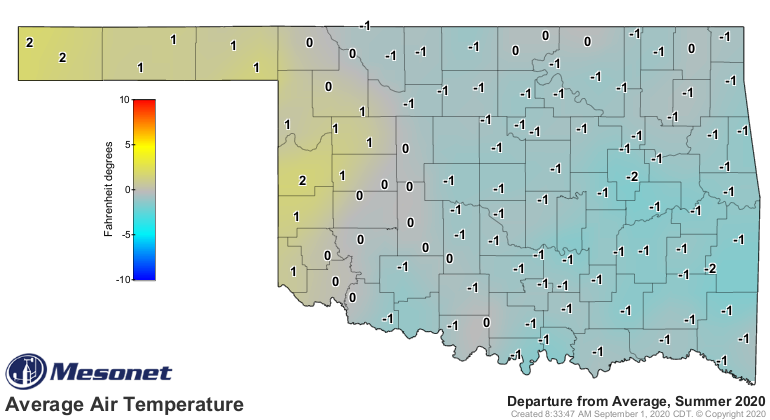
The triple dose of cold air during August brought Oklahoma’s statewide average
temperature down 1.8 degrees below normal according to preliminary data from
the Mesonet. The month finished at 79 degrees to rank as the 26th coolest
August on record, dating back to 1895.
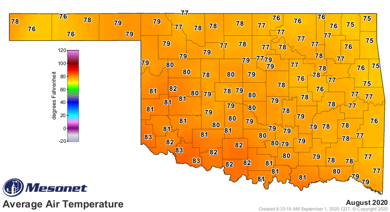
Heat was still present during August, owing to its summer roots. Temperatures
soared into the triple digits at times, topping out at 110 degrees at both
Camargo and Hollis on the 28th. Oklahoma City recorded its first triple-digit
temperature of the summer that day at 102 degrees. Heat index values indicated
oppressive heat was even more widespread. Idabel’s heat index rose to 118
degrees on the 29th. The Mesonet’s 120 sites recorded heat index values of at
least 105 degrees 546 times during August. The state’s lowest temperature was
53 degrees at Cookson on the 19th. Summer finished with a statewide average
temperature of 80.1 degrees, 0.5 degrees above normal to rank as the 58th
warmest June-August on record. The first eight months of the year ranked as the
25th warmest at 63.2 degrees, a degree above normal.
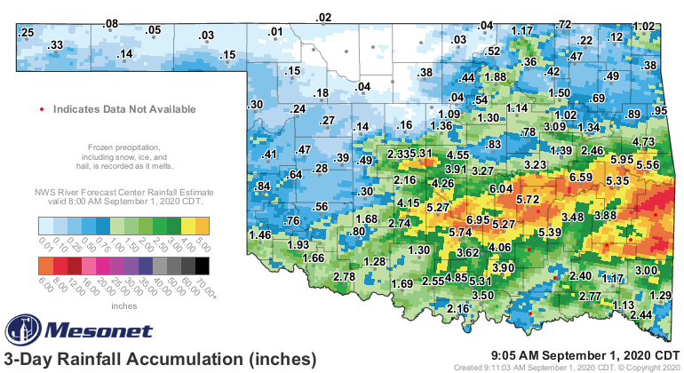
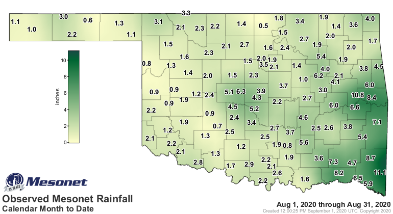
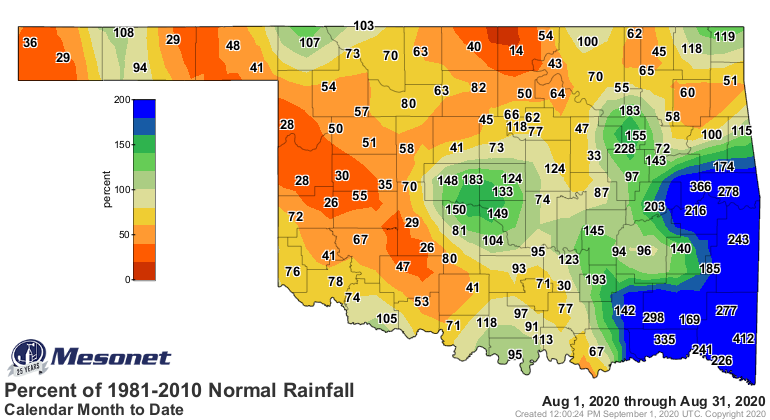
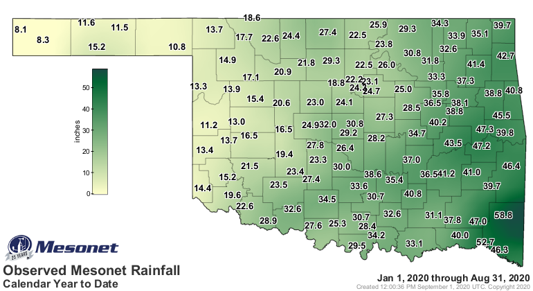
August was dry for the most part, but saved somewhat by the late-month storm
system that brought flooding rains across central and southeastern Oklahoma.
The statewide average total of 2.94 inches was just 0.01 inches below normal
to rank as the 57th wettest on record. That total belied the actual experiences
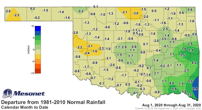
across the state, however. The Panhandle fell 1.13 inches below normal for
their 29th driest August on record, while the southeast was 4.06 inches above
normal for their fifth wettest. The far southeast was 4-8 inches above normal,
bolstered by tropical rains from Hurricane Laura. Nevertheless, most of the
state was somewhere between 1-3 inches below normal. The Mesonet site at Broken
Bow led the month’s totals at 11.13 inches, and Blackwell brought up the rear
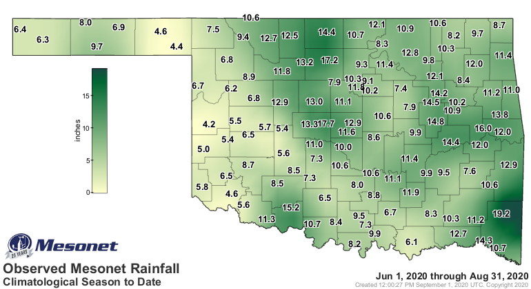
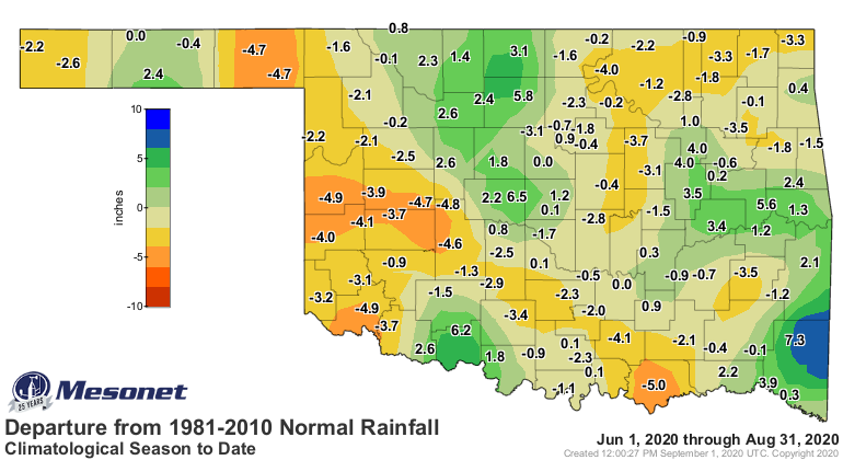
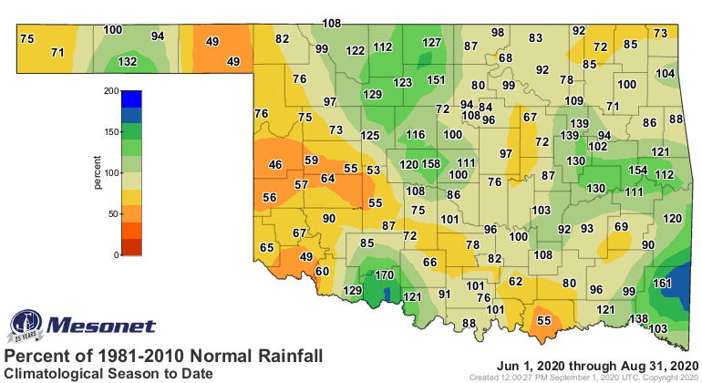
with 0.49 inches. The summer finished at 9.55 inches to rank as the 55th driest
on record, 0.80 inches below normal. The January-August average total of 28.06
inches was 3.2 inches above normal to rank as the 21st wettest such period on
record.
August
------
Summer
------
Year-to-date
------------
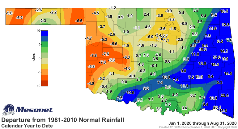
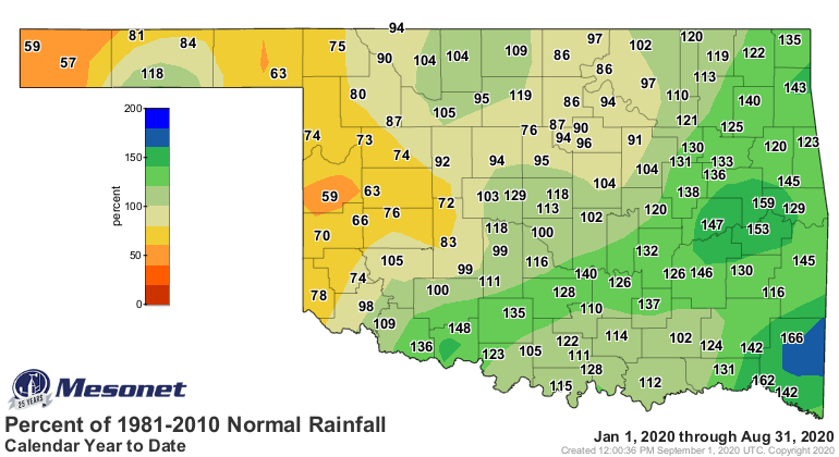
The worst drought conditions continued across southwestern and west central
Oklahoma. The U.S. Drought Monitor portrayed most of the western third of the
state in moderate-to-severe drought intensity, with small areas of extreme
drought centered on Harmon and Beckham counties. Severe drought also existed
in northern Cimarron County. The Drought Monitor’s intensity scale slides from
moderate-severe-extreme-exceptional, with exceptional being the worst
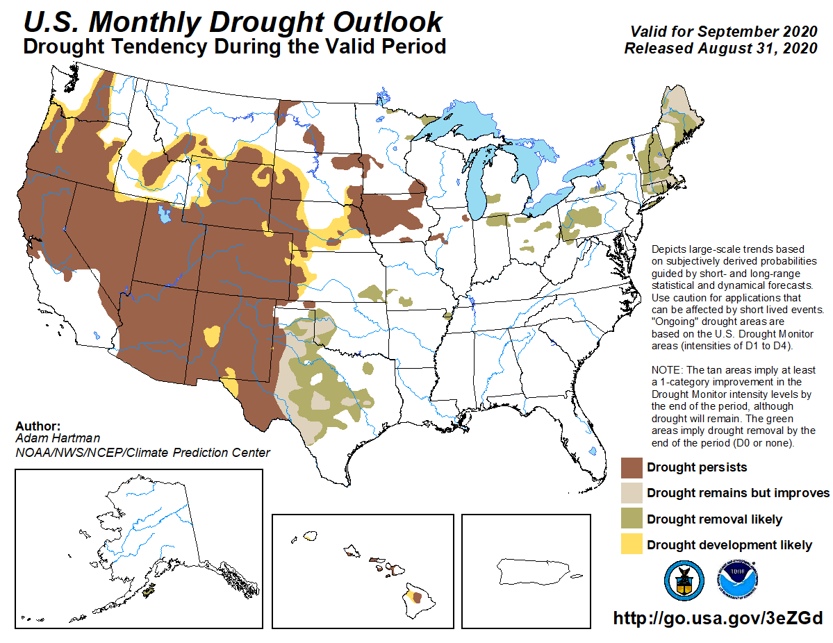
classification. The chance for drought relief appears greatest in the main body
of the state, according to the Climate Prediction Center’s (CPC) September
drought outlook. The drought is expected to persist and possibly intensify
where it currently exists in the Panhandle. The drought outlook is based partly
on CPC’s September precipitation outlook, which sees increased odds of above
normal precipitation in all but the Panhandle, where increased chances of
below normal rainfall are indicated. The September temperature outlook shows
increased chances for below normal temperatures across the eastern two-thirds
of Oklahoma.
Gary McManus
State Climatologist
Oklahoma Mesonet
Oklahoma Climatological Survey
(405) 325-2253
gmcmanus@mesonet.org
September 1 in Mesonet History
| Record | Value | Station | Year |
|---|---|---|---|
| Maximum Temperature | 110°F | WAUR | 2000 |
| Minimum Temperature | 49°F | GOOD | 2024 |
| Maximum Rainfall | 7.50″ | BYAR | 2020 |
Mesonet records begin in 1994.
Search by Date
If you're a bit off, don't worry, because just like horseshoes, “almost” counts on the Ticker website!