Ticker for August 1, 2023
MESONET TICKER ... MESONET TICKER ... MESONET TICKER ... MESONET TICKER ...
August 1, 2023 August 1, 2023 August 1, 2023 August 1, 2023
July is in the books!
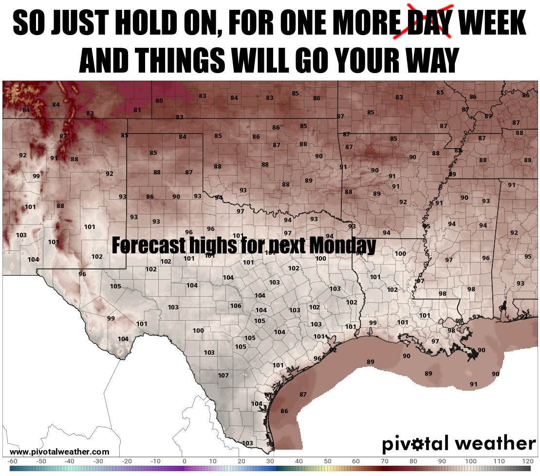
Don't worry, relief's coming! For the heat, that is. That phrase is also
commonly uttered after you send somebody to the store to get some Imodium after
eating at Taco Bell. We will continue with the heat until at least halfway
through the weekend for most of us.

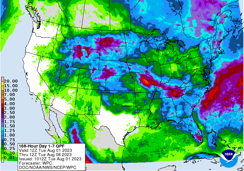
Rain chances should come back as early as Thursday up north, and spreading to
the south as we get into the weekend. Maybe not as monumental as we saw in
July, but enough to keep the clouds around and the dust settled.
Speaking of July, did you know (or maybe remember) that we set an all-time
Mesonet record last month?
Most snow? No.
Most sunshine? No.
Most hair? Did you have to go there?
Well if you want to find out what for, and many other scintillating (to me)
tidbits about the July weather, AND what's coming up for August...read on,
MacDuff.
----------------------------------------------------------------------------------
July Rains Ease Drought
Aug. 1, 2023
The unusually wet and mild weather Oklahoma enjoyed through much of May and
June continued into July, providing the state with uncharacteristic summertime
drought relief. The Southern Plains heat dome still managed to meander its way
over Oklahoma for short periods, however, basting the state in intense heat and
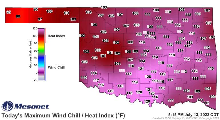
stifling humidity. The Oklahoma Mesonet site at Pauls Valley reached a network-
record heat index of 126 degrees on July 13, besting the previous record of 125
degrees from Calvin back on Aug. 9, 1999. The Mesonet’s heat index records date
back to 1997. Summer returned in earnest beginning July 23, extending through
the end of the month with highs in the upper 90s and 100s. July was the first
month since September 2022 without a tornado report in the state. The
preliminary count through the first seven months of the year stood at 63,
already above the 1951-2022 annual average of 57.3 tornadoes with five months
remaining.
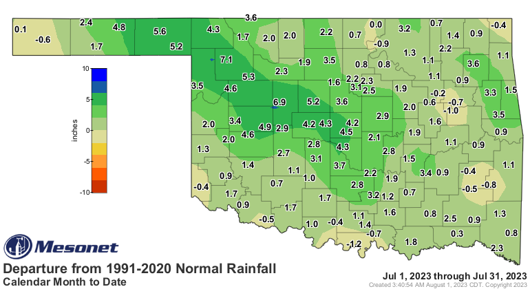
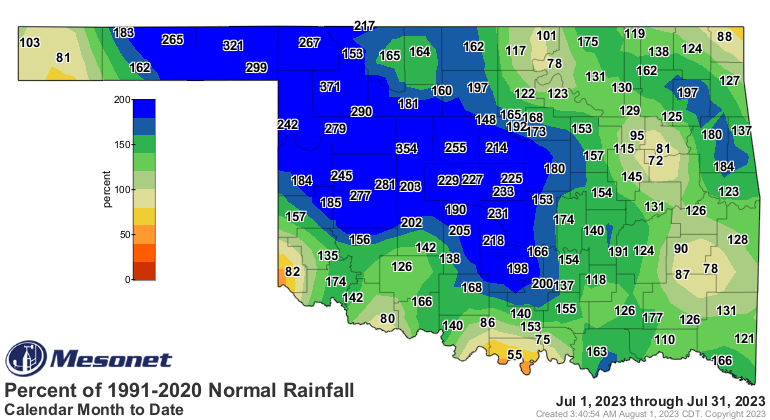
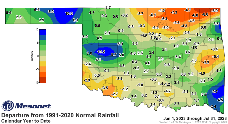
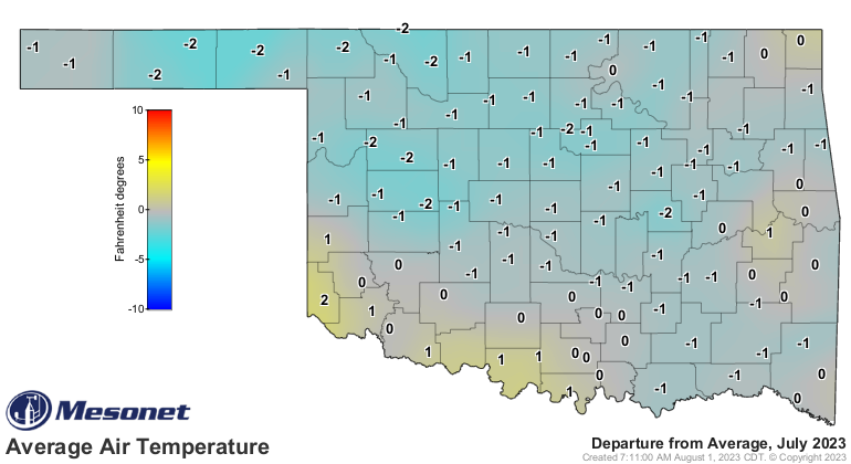
The statewide average rainfall total for the month was 5.19 inches, 1.99 inches
above normal and ranked as the 13th wettest July since records began in 1895.
Nearly the entire state finished the month with a surplus, save for localized
areas across far southern and northern Oklahoma where deficits of up to an inch
were reported. The surplus rain totals from the eastern Panhandle through
central Oklahoma were tremendous, however, at 3-7 inches above normal. Each of
the 10 highest July rainfall totals were at Mesonet sites within that swath,
from Woodward’s 9.71 inches to Norman’s 7.62 inches. The Panhandle, west
central, and central Oklahoma all enjoyed top 10 wettest July rankings of sixth,
third, and seventh, respectively. Sixty-one of the Mesonet’s 120 sites recorded
at least 5 inches of rain for the month, and another 31 saw at least 4 inches.
Burneyville in far south central Oklahoma reported the lowest total at 1.42
inches. Grandfield and Hollis also received less than two inches during July at
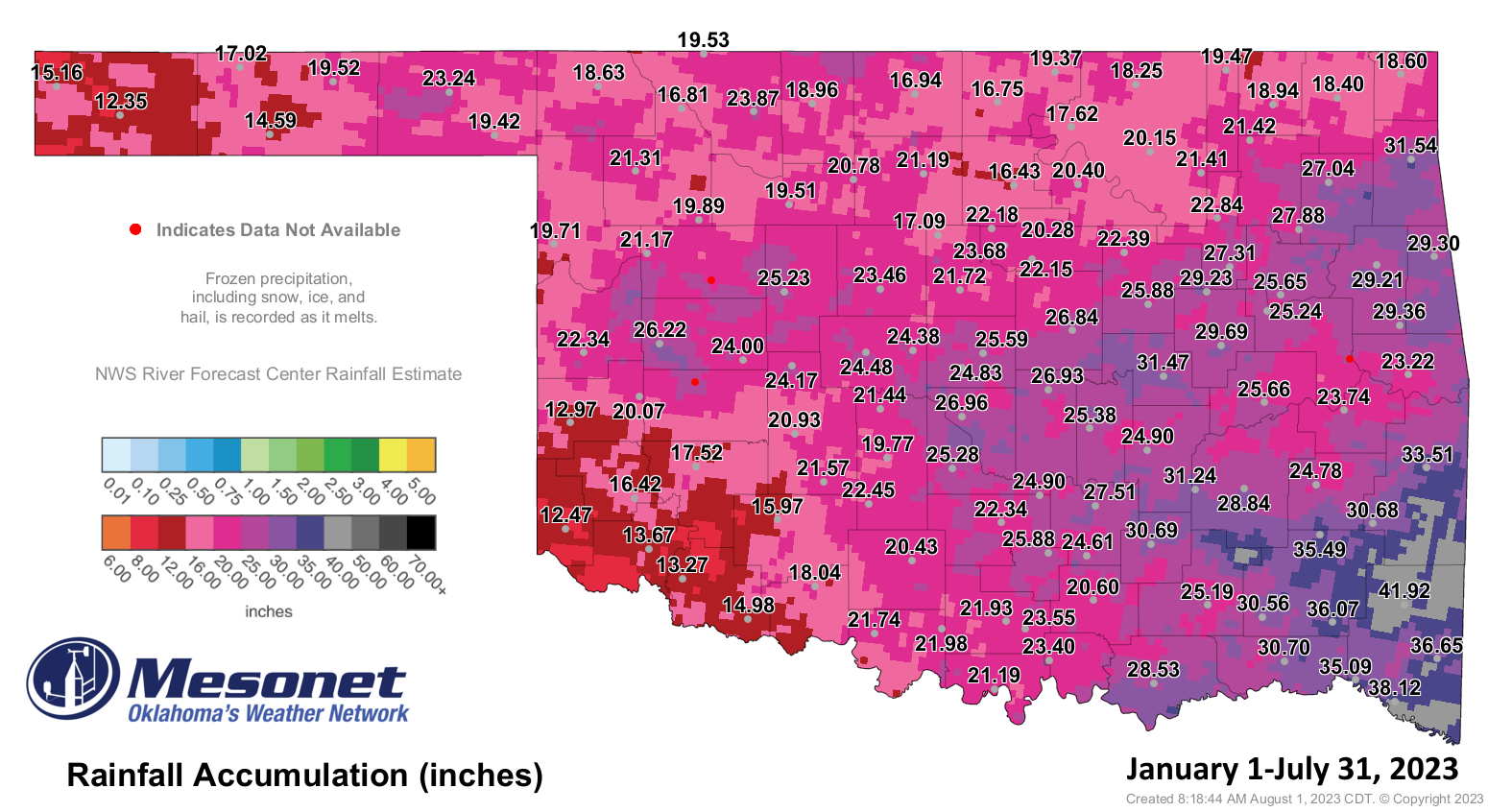
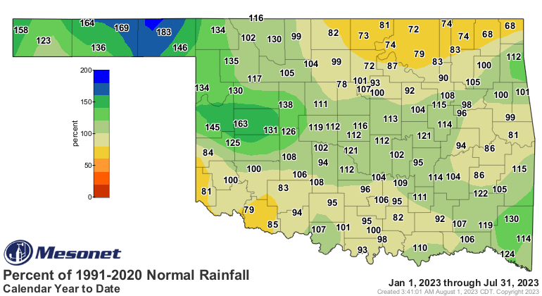
1.94 and 1.89 inches, respectively. The January-July statewide average of 22.83
inches was 0.81 inches above normal and ranked as the 43rd wettest such period
on record.

The statewide average temperature for the month was 81 degrees, 0.9 degrees
below normal and ranked as the 54th Coolest July since records began in 1895.
Grandfield recorded the month’s highest temperature of 109 degrees on three
separate days—July 18th, 19th, and 25th. The lowest reading of 55 degrees
occurred at Eva and Kenton on July 2, and again at Eva on July 3. In addition
to the 126 degrees at Pauls Valley, the Mesonet recorded heat index values of
at least 110 degrees 346 times at its 120 sites during July. The highest
recorded Oklahoma temperature of 2023 thus far was 113 degrees, recorded at
Altus on June 28. The statewide average temperature for the first seven months
of the year was 60.5 degrees, 0.5 degrees above normal and ranked as the 30th
warmest January through July on record.

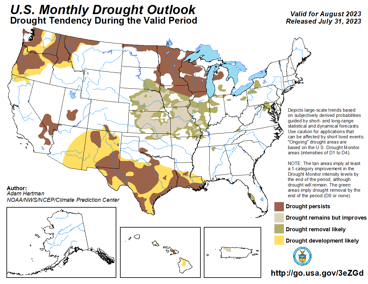
Drought coverage in Oklahoma dropped from 36% of the state at the end of June
to about 18% at the end of July, leaving all but far southwestern and north
central Oklahoma free of the climate hazard. Still, those regions remained in
severe to extreme drought, exacerbated by longer-term deficits that stretch
back to August 2021 and amplified by the summer of 2022’s disastrous flash
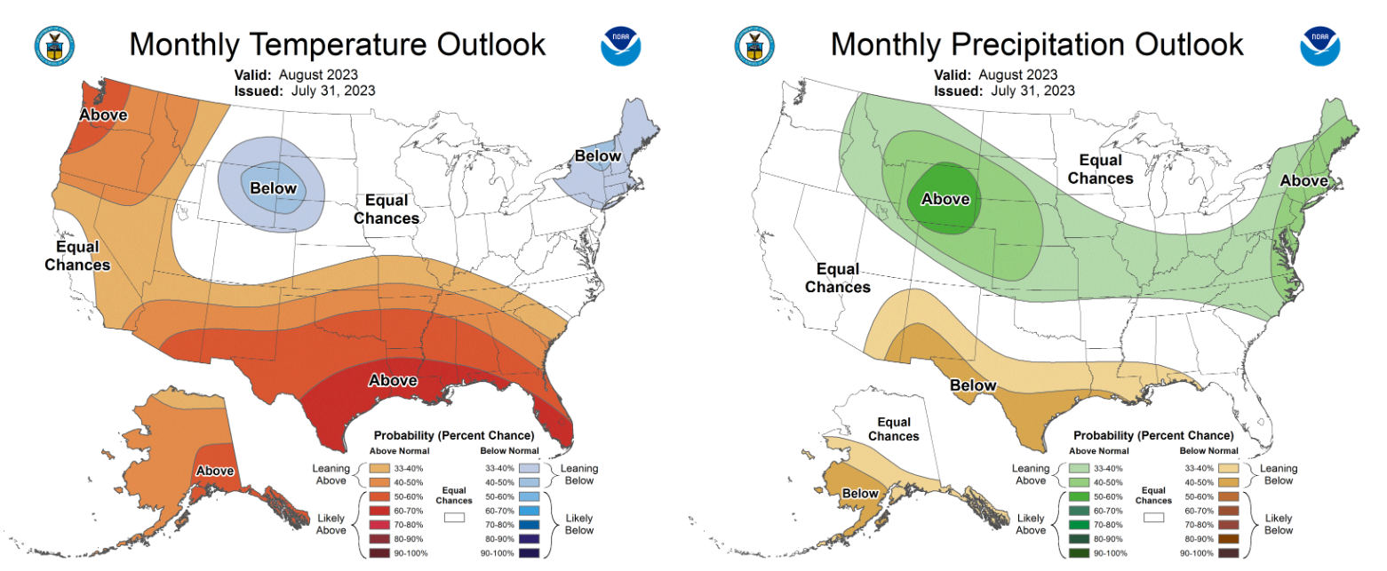
drought. The Climate Prediction Center’s August outlooks show increased odds
for above normal temperatures across the entire state, and above normal
precipitation across far north central Oklahoma. CPC’s corresponding August
drought outlook sees it being relieved—and partially eradicated—across the area
of drought in northern Oklahoma, but persisting across far southwestern
sections of the state. However, no new areas of drought are expected to develop
through August.
###
Gary McManus
State Climatologist
Oklahoma Mesonet
Oklahoma Climatological Survey
gmcmanus@mesonet.org
August 1 in Mesonet History
| Record | Value | Station | Year |
|---|---|---|---|
| Maximum Temperature | 115°F | KIN2 | 2012 |
| Minimum Temperature | 53°F | KENT | 2018 |
| Maximum Rainfall | 5.04″ | NOWA | 1995 |
Mesonet records begin in 1994.
Search by Date
If you're a bit off, don't worry, because just like horseshoes, “almost” counts on the Ticker website!