Ticker for August 1, 2012
MESONET TICKER ... MESONET TICKER ... MESONET TICKER ... MESONET TICKER ...
August 1, 2012 August 1, 2012 August 1, 2012 August 1, 2012
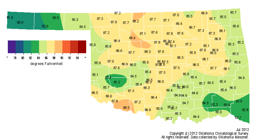
July Blazes to Sixth Warmest on Record as Drought Expands
Heat exploded across Oklahoma during July thanks to a rapidly intensifying drought
and a persistent upper-level ridge of high pressure. The combination of dry soils,
wilting vegetation and a brutal summer sun led to the sixth warmest July on
record for the state. Those records date back to 1895. According to preliminary
data from the Oklahoma Mesonet, the statewide average temperature finished at 85.9
degrees, 4.3 degrees above normal. July becomes the 23rd month out of the last 28
to finish warmer than normal, a persistent signal that began in April 2010. The
first two months of summer were the ninth warmest on record at 3.2 degrees above
normal. The January-July statewide average of 63.9 degrees was easily the warmest
on record for the first seven months of the year at 4.8 degrees above normal. The
heat broke or tied four daily records during the month at Oklahoma City and twice
at Tulsa, including that city?s all-time high minimum temperature. Tulsa?s
temperature only dropped to 88 degrees on July 30, breaking the previous all-time
record high minimum temperature of 87 degrees set on August 2, 2011, and July 16,
1980. The highest temperature recorded during the month was 112 degrees on July
31 at several locations. The century mark was reached at all 120 Mesonet
stations on both July 29 and July 31.
July temperature maps
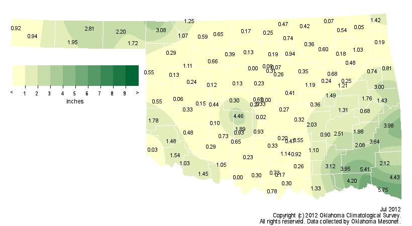
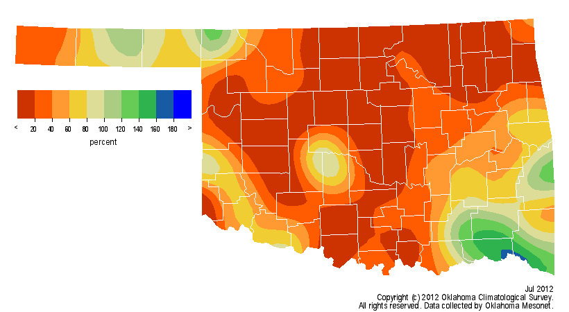
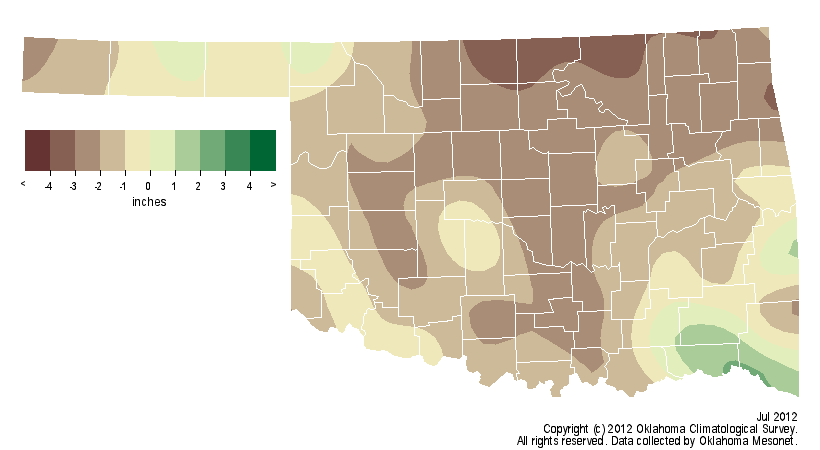
The month was also the 15th driest July on record with a statewide average
rainfall total of 1.11 inches, 1.63 inches below normal. The moisture deficit
during July continued a dry streak that began in April and intensified during
May, encompassing the bulk of Oklahoma?s primary rainy season. The May-July
statewide average rainfall total of 5.99 inches fell 6.25 inches below normal
and ranked as the third driest such period on record. Three of the 120 Oklahoma
Mesonet stations ? Marshall, Spencer and Waurika ? recorded no rainfall for the
month of July and 10 recorded less than a tenth of an inch. Idabel led the state
with 5.75 inches. July 31 marked the 55th day since the Mesonet stations at both
Norman and Watonga recorded more than a tenth of an inch of rain in a single
calendar day.
July rainfall maps
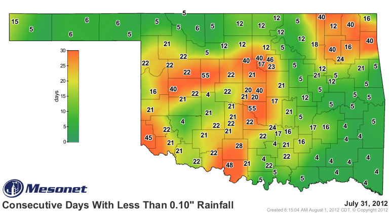
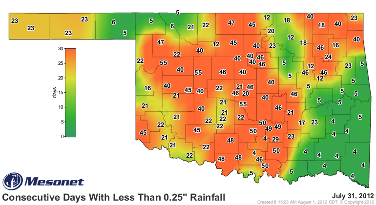
Consecutive days without 0.10" and 0.25" maps
The drought?s impacts became more significant as the month progressed. The USDA
rated the moisture levels of 96 percent of the state?s topsoils and subsoils as
either ?poor? or ?very poor? in a report released on July 30. That report also
rated 64 percent of the state?s pastures and rangelands as being in either ?poor?
or ?very poor? condition. County-level USDA offices from across the state reported
a rapid deterioration of crops and vegetation as well as diminishing stock ponds.
The lush green growth of the state?s warm and wet early spring was transformed
into abundant fuel for wildfires as it became dormant or dead. Many large fires
were reported during the latter half of the month.
The latest U.S. Drought Monitor report indicated severe to extreme drought had
crept into the state from both the east and the west, with 64 percent of Oklahoma
now portrayed in at least severe drought. That is the highest such level since Nov.
22, 2011, when the drought had just begun to diminish following its zenith in
October. Approximately 15 percent of the state is considered in the extreme
drought category, the highest percentage since early March when the drought
appeared headed towards extinction. The Drought Monitor?s intensity scale slides
from moderate-severe-extreme-exceptional, with exceptional being the worst
category.
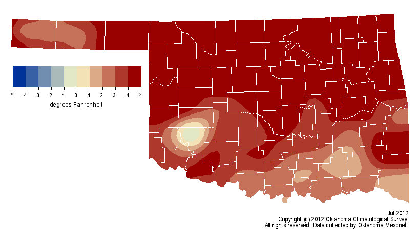
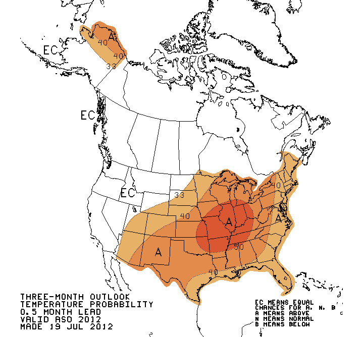
The latest temperature and rainfall outlooks from the National Weather
Service?s Climate Prediction Center are less than optimistic for widespread relief.
Increased odds of both below normal rainfall and above normal temperatures will
continue for August. The August-October temperature outlook also indicates
increased odds of above normal temperatures. August would not be considered the
ideal month for relief regardless of those outlooks as the state?s driest summer
month and the calendar?s second-hottest, next to July. Relief from summer normally
begins to arrive during September as the jet stream begins to meander back towards
the south once again, bringing cooler air and increased chances of rainfall.
August CPC outlooks
Temperature: 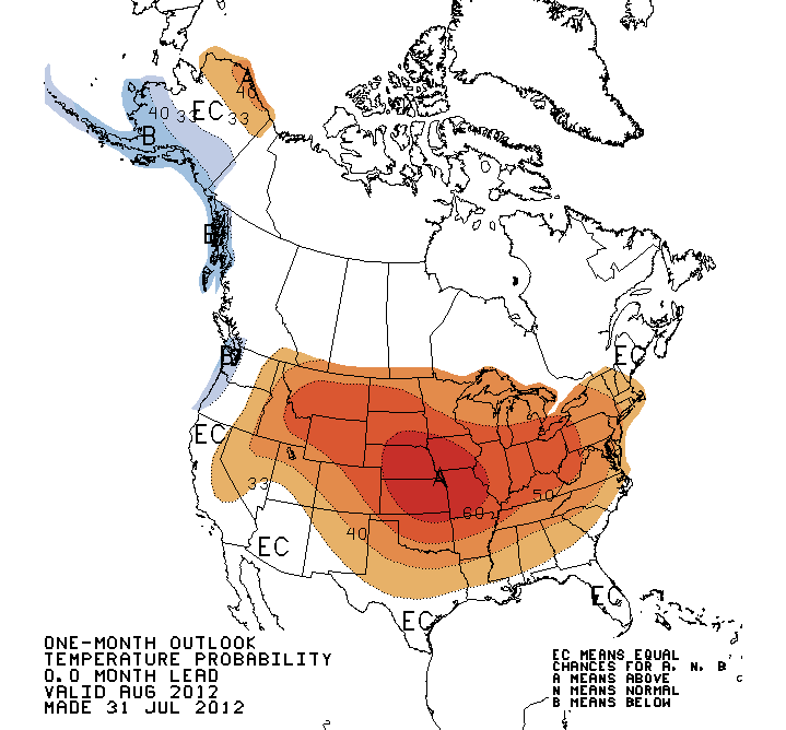
Rainfall: 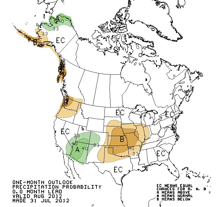
August-October CPC Temperature outlook
Gary McManus
Associate State Climatologist
Oklahoma Climatological Survey
(405) 325-2253
gmcmanus@mesonet.org
August 1 in Mesonet History
| Record | Value | Station | Year |
|---|---|---|---|
| Maximum Temperature | 115°F | KIN2 | 2012 |
| Minimum Temperature | 53°F | KENT | 2018 |
| Maximum Rainfall | 5.04″ | NOWA | 1995 |
Mesonet records begin in 1994.
Search by Date
If you're a bit off, don't worry, because just like horseshoes, “almost” counts on the Ticker website!