Ticker for December 28, 2015
MESONET TICKER ... MESONET TICKER ... MESONET TICKER ... MESONET TICKER ...
December 28, 2015 December 28, 2015 December 28, 2015 December 28, 2015
I don't know what to say?
As the monstrous post-Christmas storm of 2015 slowly winds its way through the
state to the northeast, we remain with life-threatening flooding across eastern
Oklahoma, a frozen western half of the state, and over 100,00 utility customers
without power. Here's the radar loop so you can watch this unwanted guest leave
the area.
http://radar.weather.gov/ridge/Conus/southplains_loop.php
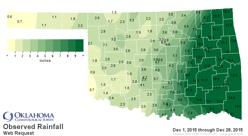
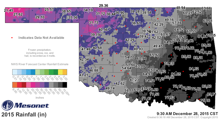
I don't even know how to begin to describe the amount of wind and moisture with
this storm, so I'll just jump right in. First, the moisture. Take a look at the
3-day rainfall map (remember, some of the stations across western OK are still
waiting for the frozen precip to melt).
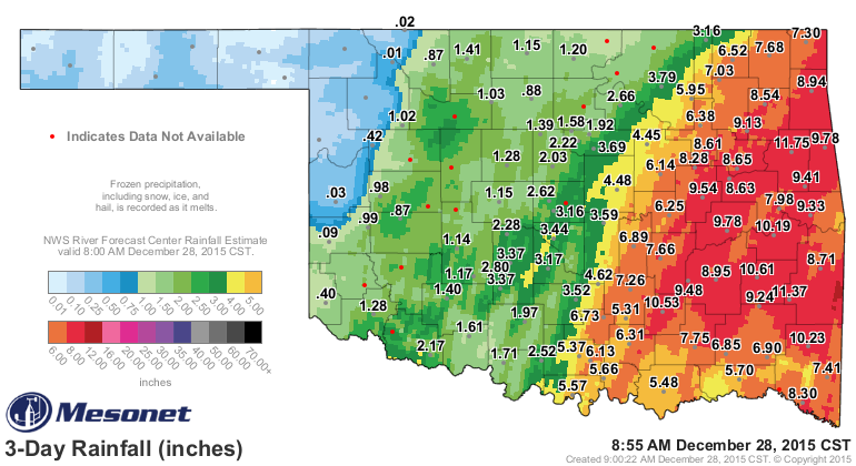
A wide area of 4-12 inches of rain fell across the eastern half of the state, as
well as 1-3 inches of rain/snow/sleet/freezing rain across the western half.
Tahlequah led the Mesonet with 11.75 inches, and rain is still falling! The eastern
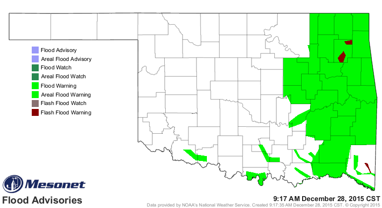
half of the state is littered with flash and areal flood warnings. In some cases,
this is the flood of record for those river basins.
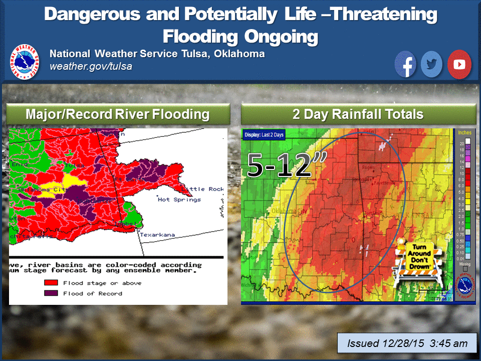
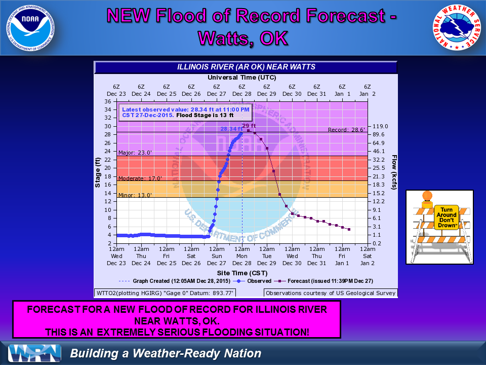
Places like Watts, OK, are experiencing their flood of record on the Illinois
River.
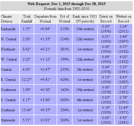
Ugh, so much to talk about I don't even know where to continue. Can you believe
that? THE TICKER IS SPEECHLESS! Let's turn to records. The statewide average
rainfall for December thus far, at least according to preliminary data from
the Mesonet, is 5.71 inches (and climbing), 3.81 inches above normal, which
makes it the wettest December on record! The previous record was 4.87 inches
from 1984. Remember that? I don't either, but it must have been pretty wet. Here
are the rainfall stats and a map or two from December thus far.
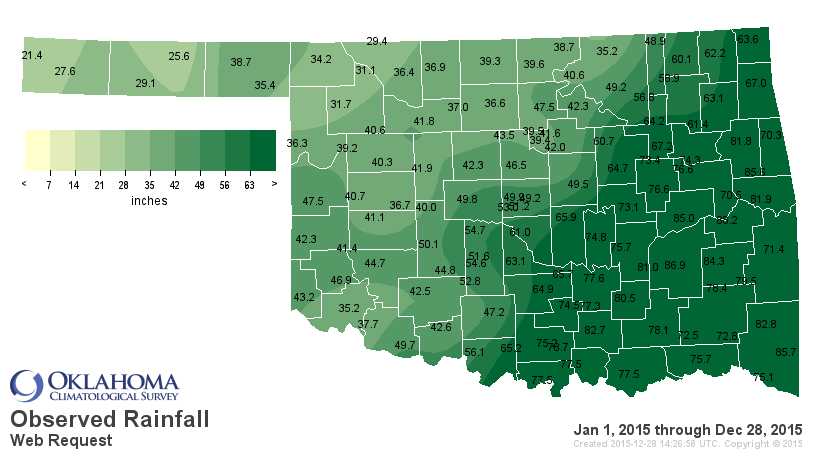
Now, add that 5.71 inches to the January-November statewide average of 48 inches
and we now stand at a preliminary total of 53.71 inches. We had already topped
the wettest year on record for Oklahoma (47.88 inches) through November, so get
this. Everybody grab a knee.
WE HAVE NOW SMASHED THE PREVIOUS WETTEST YEAR ON RECORD FOR OKLAHOMA BY 5.83
INCHES!
Absolutely incredible. I don't know if you're quite getting it there. We just
topped the statewide average rainfall total by nearly 6 inches. Wow. There were
only 7 previous years above 47 inches, so let's rank them so you can see
the enormity of this new record.
2015: 53.71 inches (preliminary)
1957: 47.88 inches
1908: 47.24 inches
1915: 46.01 inches
1941: 45.83 inches
1923: 44.61 inches
1945: 41.82 inches
1905: 40.89 inches
Now we won't get the "official" total until later into January when NCEI releases
their statewide average, but safe to say it will be somewhere in the neighborhood
of 53-54 inches.
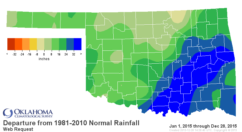
32 inches above normal. As Dr. Evil would say..."Riiiiiiiiiiiighhhhhhhhhhtttt."
Here's another year-to-date map with the radar overlay thrown in. It's a bit
easier to see, but all the stations haven't been added yet. Still, the amounts
along with the radar totals give you an idea of the enormity of the rains during
2015.
Notice some of those totals across eastern Oklahoma? Many of them are over 80
inches.
Stigler: 88.21 inches
McAlester: 86.97
Broken Bow: 85.71
Cookson: 85.61
Eufaula: 85.06
Wilburton: 84.32
Mt. Herman: 82.80
Tishomingo: 82.78
Sallisaw: 81.90
Tahlequah: 81.85
Stuart: 81.05
Centrahoma: 80.56
The previous highest total for any Mesonet station prior to 2015 was 76.61 inches
from Broken Bow back in 2009. So those 12 stations have topped that record, and
an additional 10 stations exceeded it as well, but fell below 80 inches. Now
here's the kicker (a Ticker kicker!!). The highest annual total for any site
in the history of the state (so Mesonet, NWS COOP, ect.) was 88.27 inches from
Tuskahoma back in 1990. A station called "Flagpole Tower" also had 84.72 inches
from 1990. So five Mesonet stations have topped Flagpole Tower for #2 on the
all-time list, and Stigler is dangerously close to topping Tuskahoma as the
wettest location in the history of the state.
Incredible, eh?
Please stay tuned to our Facebook and twitter accounts for updates.
TUSKAHOMA MUST FALL!!
http://www.facebook.com/mesonet/
https://twitter.com/okmesonet
Gary McManus
State Climatologist
Oklahoma Mesonet
Oklahoma Climatological Survey
(405) 325-2253
gmcmanus@mesonet.org
December 28 in Mesonet History
| Record | Value | Station | Year |
|---|---|---|---|
| Maximum Temperature | 80°F | VALL | 2021 |
| Minimum Temperature | 4°F | EVAX | 2017 |
| Maximum Rainfall | 1.84″ | PORT | 2019 |
Mesonet records begin in 1994.
Search by Date
If you're a bit off, don't worry, because just like horseshoes, “almost” counts on the Ticker website!