Ticker for May 5, 2014
MESONET TICKER ... MESONET TICKER ... MESONET TICKER ... MESONET TICKER ...
May 5, 2014 May 5, 2014 May 5, 2014 May 5, 2014
Maugust
Oklahoma is burning, both literally and figuratively, as a combination of
drought, record heat, high winds and low relative humidity created the perfect
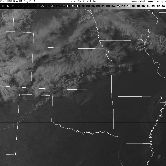
wildfire conditions yesterday. You've probably all seen the coverage of the
Guthrie fire which has burned out of control since yesterday, destroying
numerous homes and killing one man who refused to evacuate. You can see the
fire on yesterday's visible satellite image. There were at least two other large
fires in northwestern Oklahoma as well in Woodward and Dewey counties.
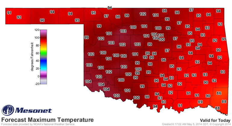
Temperatures reached the triple digits at 17 different Mesonet locations
yesterday, the most ever for this early in the season. Back on May 8, 2011, 31
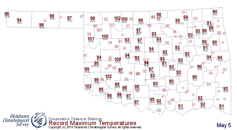
stations reached at least 100 degrees. Check out the high temperatures yesterday
and compare them with the historical record highs for all the May 4ths going
back to the 1880s or so. Lots of records fell where the drought is at its worst
across western and northern Oklahoma.
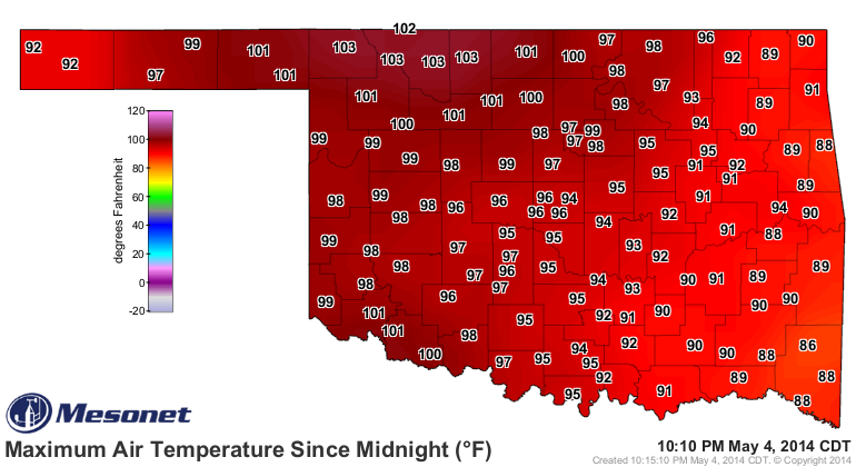

Here's a list of the Mesonet's triple-digit readings yesterday.
-***-
Alva 103 Medford 101
Buffalo 103 Slapout 101
Cherokee 103 Tipton 101
Freedom 103 Woodward 101
May Ranch 102 Blackwell 100
Altus 101 Breckinridge 100
Beaver 101 Grandfield 100
Fairview 101 Seiling 100
Lahoma 101
-****-
Of course it doesn't help that the intensifying drought has kept most of the
vegetation in a winter-like state, or more apt to the warm season conditions,
like August. "Maugust?" Could also have been termed "Muly," I guess. With so
much dormant and dead vegetation leftover from winter, it still seemed like
late summer to me. I've showed this before, but look at how "less green" the
state is from what is normally seen this time of year.

That's mostly due to drought, but the much cooler than normal weather we saw
since the beginning of the year didn't help much. When it did rain (and that
wasn't very often), it was also usually cool, so it's tough to green those
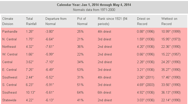
plants up when we have that combination (or lack thereof). Check out the year-
to-date rainfall maps and see just how dry it's been across northern and western
Oklahoma.

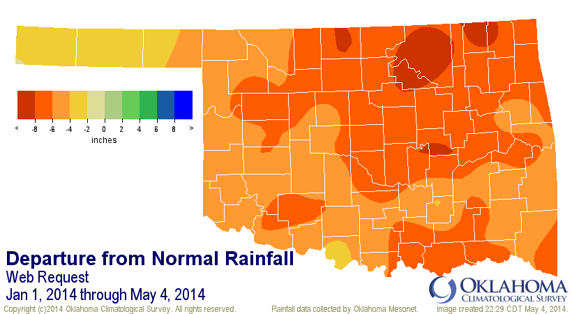

And here you can see with a statewide average of 4.22", the deficit for the
year thus far is over 6", the 2nd driest such period on record for the state
since 1921 (as measured currently by the Oklahoma Mesonet).
Oklahoma City's year-to-date precip total of 2.69" is perilously close to being
the driest January 1-May 4 on record, dating back to 1891. The Dust Bowl year
of 1936 holds the futility record for that period with 2.16".

But that's the case for many, many locations across northern and western
Oklahoma. Ponca City, for instance, is also suffering through its 3rd-driest
such period on record with 2.67". Normal over that period is 9.17".

And all the days like yesterday, even if there wasn't a lot of heat to go with
it, took its toll on the surface water supply, whether that was in a lake or
it was in the soil. Take a look at this map of state reservoir levels from
the Oklahoma Water Resources Board and see where your favorite body of water
sits.

Once again, we're in a horse race to the summer season when Mother Nature gives
us that lovely mid-to-upper level ridge of high pressure that shuts off our
rain and brings us a classic Oklahoma mid-June through mid-September Easy Bake
Oven period. From now until mid-June is normally our wettest time of the year.
If we enter the summer with THIS drought in place

well I don't know what to tell ya. Wait, yes I do. Start researching the summer
of 2011. It might come in handy. Where were we in the summer of 2011, drought-
wise? Compare the two and then you tell me.

Look familiar?
I heard that "ugh."
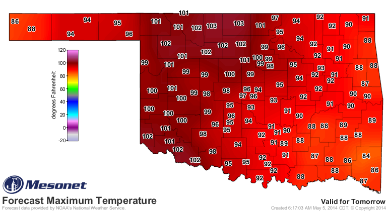
Okay, we have a couple more really hot Maugust days to go with high-to-extreme
fire danger to go before we get another chance at significant rainfall. Look
for record highs to fall again over the next couple of days. Here are the
forecast highs (I've thrown in the record highs for today so you can keep track
of your local records).

The projected rainfall map looks rather nice with lots of greens and blues for
Oklahoma, but isn't that how it has always looked this year, only to end up
with nearly all of it pushed farther to the east? Besides, that half-inch or
less across the western third-to-half of the state will barely keep up with
evaporation and what the plants are sucking from the ground.

That's about it. All I can tell you is to hang on until Thursday and we'll
actually see May again (although it's close to looking like "Mune."

Gary McManus
State Climatologist
Oklahoma Mesonet
Oklahoma Climatological Survey
(405) 325-2253
gmcmanus@mesonet.org
May 5 in Mesonet History
| Record | Value | Station | Year |
|---|---|---|---|
| Maximum Temperature | 106°F | ALTU | 2012 |
| Minimum Temperature | 29°F | KENT | 2013 |
| Maximum Rainfall | 4.13″ | WEB3 | 2022 |
Mesonet records begin in 1994.
Search by Date
If you're a bit off, don't worry, because just like horseshoes, “almost” counts on the Ticker website!