Ticker for February 11, 2021
MESONET TICKER ... MESONET TICKER ... MESONET TICKER ... MESONET TICKER ...
February 11, 2021 February 11, 2021 February 11, 2021 February 11, 2021
SNOWPACOLYPSE IS NIGH!
I'm sure you've all heard of the impending doom thrust upon us by Mother Nature.
You know, of biblical proportions? Old Testament, kind reader, real wrath-of-God
type stuff. Fire and brimstone coming down from the skies, rivers and seas
boiling. Forty years of darkness. Earthquakes, volcanoes...the dead rising from
the grave. Human sacrifice, dogs and cats living together, mass hysteria!
Darn, that sounds like we're about to be hit by the Staypuft Marshmallow Man! In
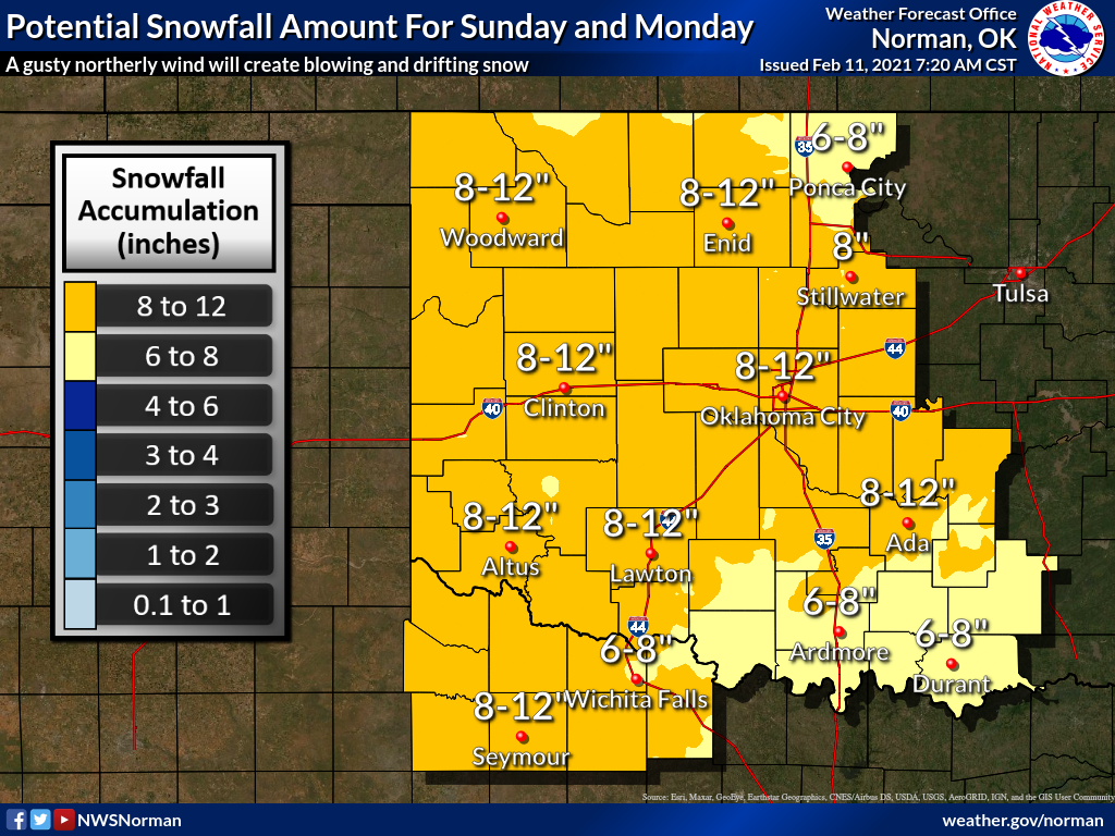
actuality, a big snowstorm now appears more likely than not for late Saturday
night into Monday (with another dose on Wednesday, possibly). Amounts could and
probably will change, but with the forecast data coming right now, we could be
looking at upwards of a foot or more of snow across much of the state by the time
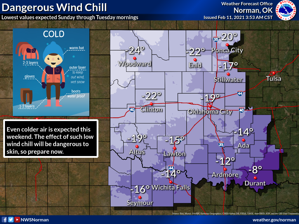
it's over late Monday. In addition to that, we will see a surge of truly cold air
on Sunday that will bring wind chills into the -20 or less range across a large
portion of the region. Remember, "or less" means lower than -20, so that's worse,
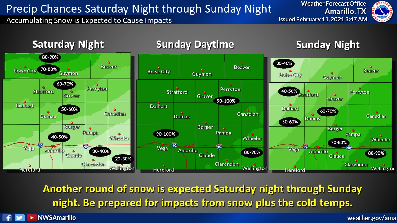
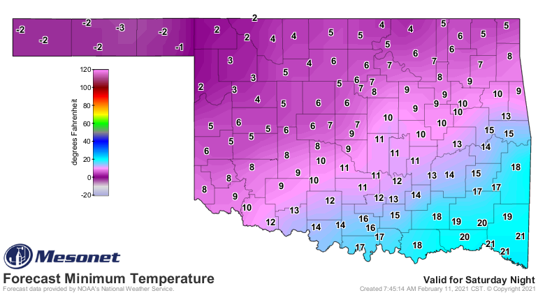
right? Here are some helpful in not dreadful graphics from our NWS friends
detailing the dangerous weather approaching for this weekend.
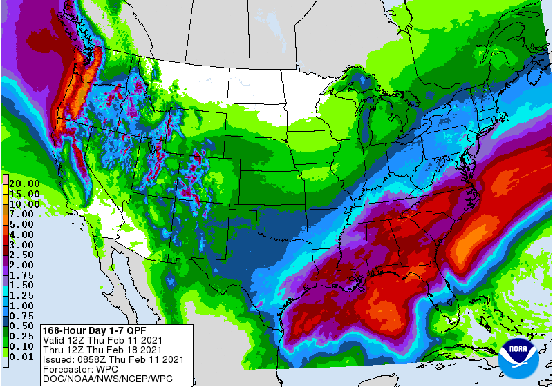
What the forecasters are dealing with here is not a lot of moisture to work
with, maybe a half-inch or so liquid equivalent (I had to type that 3 times
to spell it correctly), but with the frigid air, we'll see snow-to-liquid
ratios much higher than what we're used to seeing here in the Southern Plains;
maybe a ratio of 20:1 or even higher, which means a half inch of water is
putting at 10 inches or more. Our 24-hour snow record of 27 inches from
Spavinaw back on Feb. 9-10, 2011, came from 1.26 inches of moisture in much
the same airmass, which gives a ratio of 21:1, for example. Here is the liquid
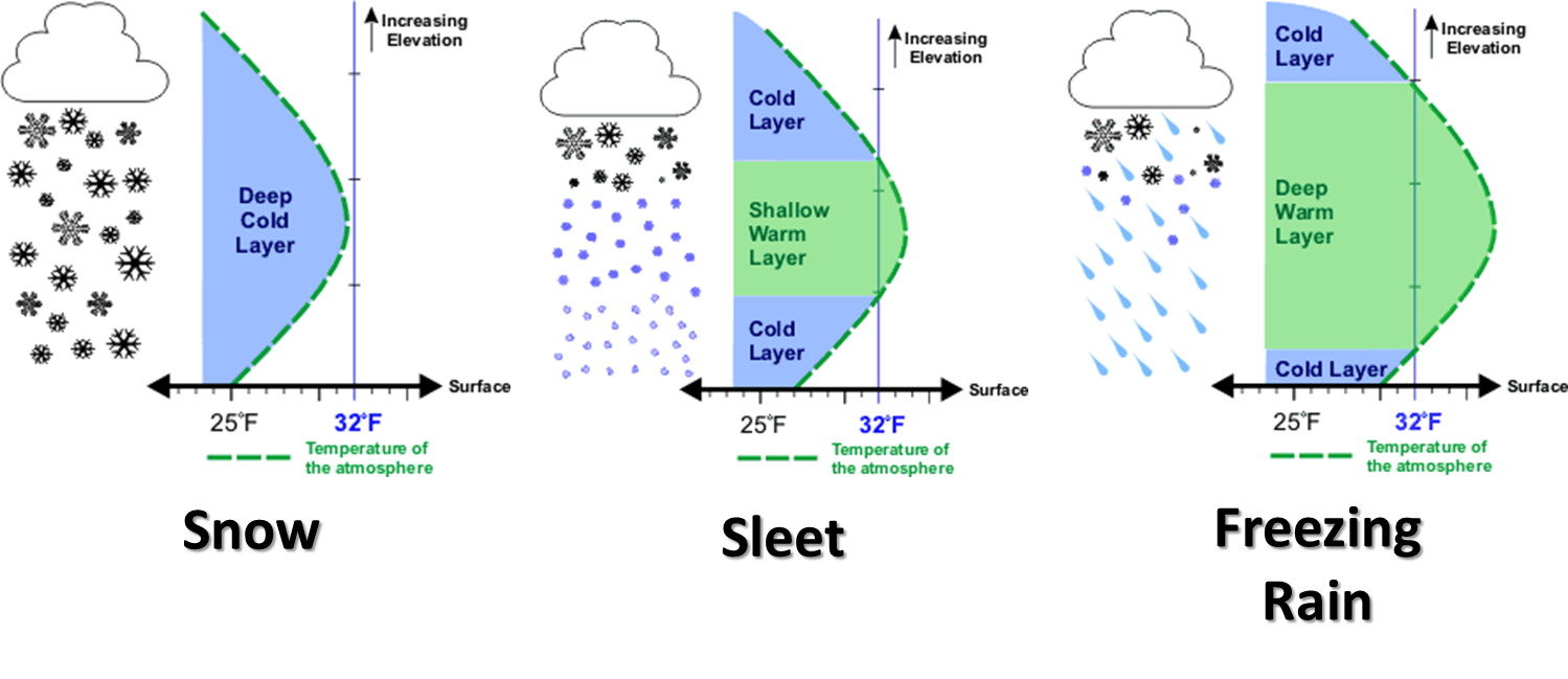
precip forecast, so this would all be converted to snow, and yet another primer
on the type of vertical temperature profile we need to see snow. We're definitely
there.
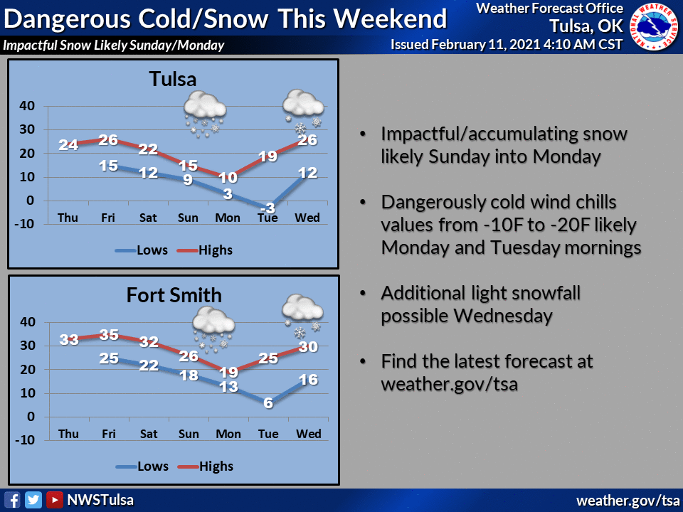
Another burst of snow on Wednesday could add an inch or more to the totals, and
the snow ain't going anywhere anytime soon. But here's the kicker...the storm
we're talking about is still out over the ocean, unsampled by our dense
observation network on land. So there's still time for the forecast to improve,
but also get worse. Remember our lesson on chaos impacting forecast models?
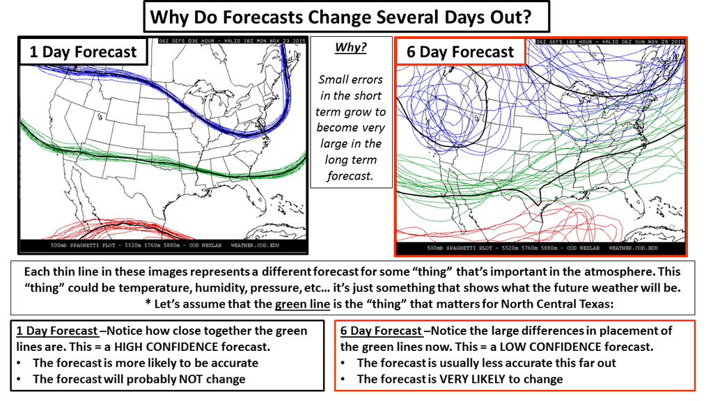
What lends some confidence to the forecast of heavy snow is that many of the
forecast models are staring to coalesce into this type of event. Much different
from many of our winter precip events lately, however, is that the entire
atmosphere is primed for snow...none of this rain-snow mix stuff, or "it will
probably sleet for awhile before it changes over to snow." Nope. All snow this
time, and it will be a powdery snow that will blow around in the strong winds.
We're going to be darned close to blizzard conditions, and drifting snow could
definitely be a problem.
The cold air is much less iffy. Once that dense blob of air starts headed south
in the absence of a strong impetus to move in another direction, it's gonna
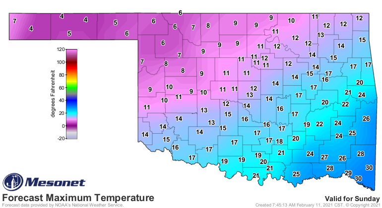
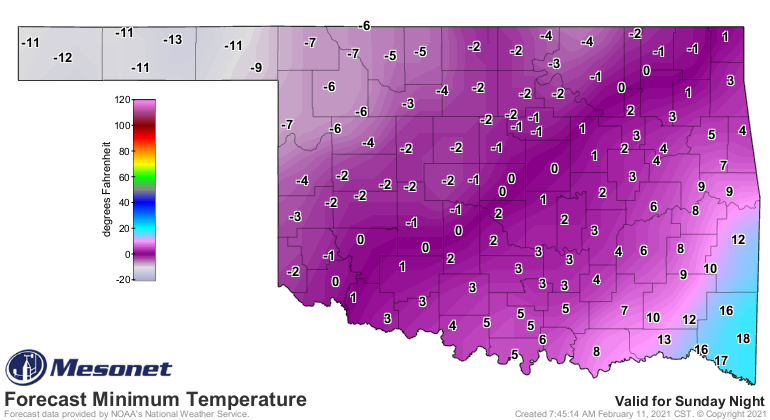
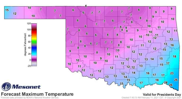
go ahead and just flow on down. Here you can see the forecast temperatures for
Sunday and Monday. It's not looking pretty, and a snowpack will only enhance
these temperatures. Should it get clear as well, these forecast LOW
temperatures could be an underestimate.
Could we challenge some of our legendary cold days of the past? Taking a look
at statewide averages, we know that Dec. 22, 1989, easily holds the top spot
at 1.9 degrees (that's taking all the highs and lows for a day and averaging
them together), ahead of Dec. 22, 1983, at 3.5 degrees. Here's a look at your
top-10 coldest days in OK history (at least from about 1915 forward, when we
had enough coverage across the state to get an accurate average).
-***-
Date Statewide Avg. Temp (F)
12/22/1989 1.9
12/22/1983 3.5
12/23/1989 3.6
12/24/1983 4.2
12/25/1983 4.7
01/04/1947 4.7
01/17/1930 5.2
01/22/1930 5.5
12/23/1983 5.6
01/12/1918 5.6
-****-
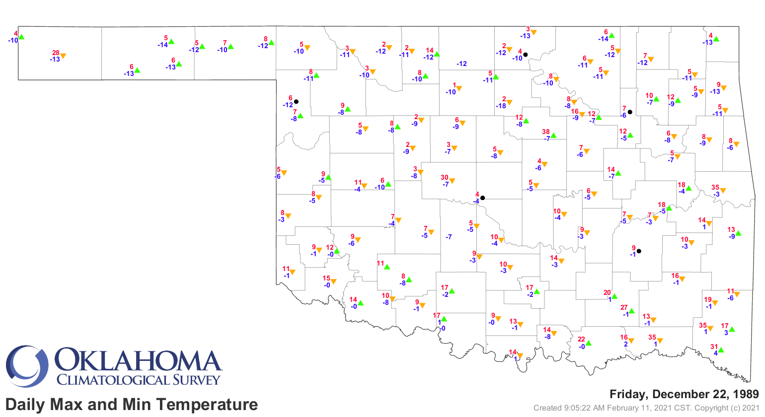
Not sure what Mother Nature has against December 22nds, but not a good day in
either 1989 or 1983. Here's what Dec. 22, 1989, looked like across the state.
Comparing the last couple of days of Mesonet statewide average temperature,
we see yesterday (Feb. 10, 2021) at 20.4 degrees and Feb. 9 at 20.5 degrees,
good for the 337th and 344th coldest days on record statewide.
We'll keep track of that, and also start to look at our 2-day to 7-day streaks,
to see where we rank there as well. For 7-day cold snaps, we're aiming for
the 7-day period ending on Dec. 25, 1983, when the statewide average over that
period was 6.8 degrees. DANG!
Gary McManus
State Climatologist
Oklahoma Mesonet
Oklahoma Climatological Survey
(405) 325-2253
gmcmanus@mesonet.org
February 11 in Mesonet History
| Record | Value | Station | Year |
|---|---|---|---|
| Maximum Temperature | 99°F | MANG | 2017 |
| Minimum Temperature | -6°F | PRYO | 2011 |
| Maximum Rainfall | 1.27″ | VANO | 2008 |
Mesonet records begin in 1994.
Search by Date
If you're a bit off, don't worry, because just like horseshoes, “almost” counts on the Ticker website!