Ticker for September 27, 2012
MESONET TICKER ... MESONET TICKER ... MESONET TICKER ... MESONET TICKER ...
September 27, 2012 September 27, 2012 September 27, 2012 September 27, 2012
Rainfall mocks drought report
The jinx monicker thrown on the most handsome and intelligent Associate State
Climatologist Oklahoma currently has (okay, so we only have one, but I'm still
technically correct) was proven to be FALSE by a lovely series of storms that
swept through the state last night. More importantly, it sort of makes the
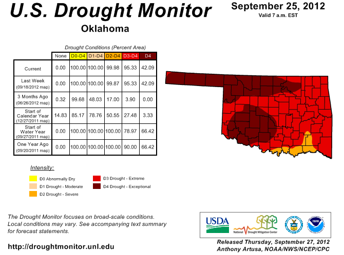
release of the latest U.S. Drought Monitor report from this morning a bit
anti-climactic (and anti-climatic). The report is basically the same picture of
Oklahoma's drought from last week. Remember the cutoff for considering
precipitation during the week for inclusion in changes is Tuesday morning, so
obviously this rain will be reflected next week. Here's a gander at where we
started before the latest rains.
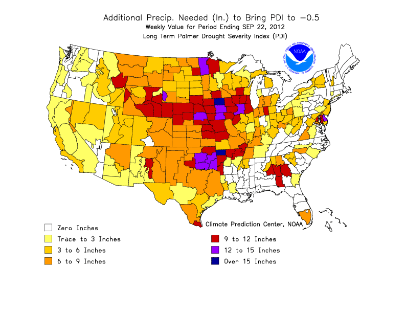
For a bit of perspective as we sit back and watch the rain fall, here is a
sorta-quasi-estimate of the amount of rainfall needed to bring us completely
out of drought. Of course, categorizing drought is not nearly that simple, but
this will at least give us an idea of what is needed (BEFORE the current rains
started falling). From 6-9 inches in the northwest to 12-15 inches in the
southeast.
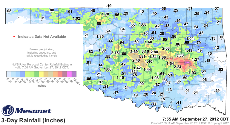
The rainfall amounts from the Oklahoma Mesonet and the radar estimates from the
RFC in Tulsa tell a wonderful story for quite a few folks in the state. This
3-day view shows a widespread area of 1-3 inches fell across the center of the
state with a few areas showing even greater amounts. That glob of reds and
purples centered on Okfuskee, Hughes, and McIntosh counties signifies rainfall
estimates of up to 8 inches! Unfortunately it failed to register on a Mesonet
gauge so it wasn't sampled by that network, but spotter reports indicated
rainfall amounts of at least 5 inches did indeed fall. The official recording
station for Oklahoma City at Will Rogers Airport picked up 1.78 inches, breaking
the old record of 1.74 inches for Sept. 27 set in 1973.
Here are the top-10 totals from the Mesonet for this latest event, at least
through 7:55am. But remember, these are gauge-measured totals. The radar
estimates were higher in some areas.
-****-
Okemah 3.53"
OKC North 3.19"
Spencer 2.80"
El Reno 2.69"
Minco 2.40"
Holdenville 2.24"
Weatherford 2.15"
Chandler 2.03"
McAlester 1.93"
OKC East 1.84"
-***-
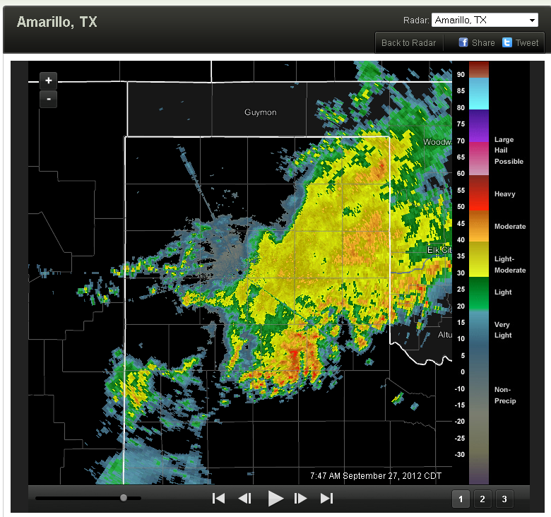
Now not everybody received rainfall. Parts of the Panhandle and areas in western,
northern and especially southeastern Oklahoma went largely without. But the good
news is this storm system is still not finished. It is raining in the state as
I type, and a large area of rainfall is moving into Oklahoma from the Texas
Panhandle.
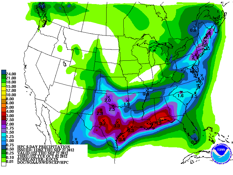
The HPC 5-day rainfall total forecast still shows 1-2 inches possible across
Oklahoma (and yes, they are still mentioning Miriam in their discussions), with
the possibility of "a large scale and widespread rain event" appearing likely
across Oklahoma and Texas on Friday and Saturday.
Jinx indeed.
HARRUMPH!!
Gary McManus
Associate State Climatologist
Oklahoma Climatological Survey
(405) 325-2253
gmcmanus@mesonet.org
September 27 in Mesonet History
| Record | Value | Station | Year |
|---|---|---|---|
| Maximum Temperature | 101°F | BUFF | 2019 |
| Minimum Temperature | 36°F | OILT | 2010 |
| Maximum Rainfall | 2.86″ | CLAY | 2012 |
Mesonet records begin in 1994.
Search by Date
If you're a bit off, don't worry, because just like horseshoes, “almost” counts on the Ticker website!