Ticker for June 24, 2011
MESONET TICKER ... MESONET TICKER ... MESONET TICKER ... MESONET TICKER ...
June 24, 2011 June 24, 2011 June 24, 2011 June 24, 2011
OKC moving up in the record books
Oklahoma City (or as we say back in Buffalo ... "the City") reached 100 degrees
today and for the sixth time this June. That now places June 2011 in a tie for
fifth place with the most triple-digit June highs dating back to 1896. Here are
your top 100-degree Junes on record for OKC:
1933 9
1911 7
1925 7
1953 7
2011 6
1918 6
1934 6
OKC needs three to tie and four to win with six chances left. Looks like it's
gonna be close. A sure bet is the number of days at or above 90 degrees. The
record for June in OKC is 27 from 1911 and the count is now 24. With the
forecast looking hot for the next 6 days, OKC will break that record. If it
doesn't, blame my colleague Dr. Mark Shafer who alerted me to the statistic.
Here are your top Junes in OKC with days of 90 degrees or higher:
1911 27
1934 25
2011 24
1953 24
1990 24
Okay, it wouldn't be a Ticker if I didn't try and doom-and-gloom you, right?
Remember 1980, of 50 days of above 100 degrees fame? It only had FIVE days of
triple-digit heat during June and 14 days above 90. There's a lot of room left
for this heat to grow.
Finally, the average temperature for the month thus far in OKC has been around
83.2 degrees. That ties it for third place as the warmest June on record in
OKC with 1934. Tops is 1953 at 84.3 degrees with 1911 in second place at 84.1
degrees.
Your Mother said it and I'll say it again. Always wear clean underwear in case
... no, that was not it. Oh yeah, here it is: be careful of the company you
keep!
*******************************************************
More on fire
Say that slowly, please. I really hate to be right about something, and as my
wife will tell you, it very rarely occurs. But the fire currently raging out of
control near Medicine Park will be more the norm without appreciable rainfall in
the western half of the state. There's just no green down there and also no
moisture. And that's not a local feature, we're talking about the whole
southwestern corner of the United States eastwards to about Oklahoma City. This
relative humidity map of the U.S. from the Oklahoma Mesonet website tells that
story pretty well.
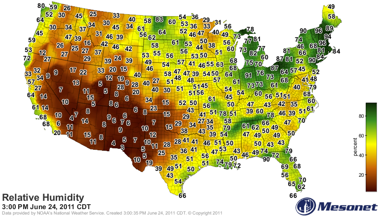
Keep in mind as you look at this that the same weather conditions that produced
the large fires in Arizona have been occurring in western Oklahoma. It was just
a matter of time before we saw similar results. The lack of green tells the
rest of the story. Check out what a difference can make with the relative
greenness map from last year at this time versus this year, courtesy of
OK-FIRE (http://okfire.mesonet.org).
last year: 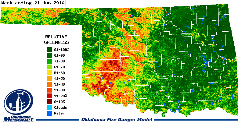
this year: 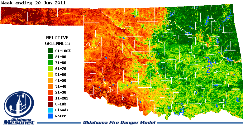
Last year's oranges and browns are what you could expect after wheat harvest
with a bit of dry weather thrown in, but compared to this year's map, the
difference is remarkable. Also notice that the greens in the eastern half of
the state last year are much darker than this year. Southeastern Oklahoma in
particular is primed for drought re-emergence due to lingering long-term
dry conditions.
Gary McManus
Associate State Climatologist
Oklahoma Climatological Survey
(405) 325-2253
gmcmanus@mesonet.org
June 24 in Mesonet History
| Record | Value | Station | Year |
|---|---|---|---|
| Maximum Temperature | 108°F | HOLL | 2011 |
| Minimum Temperature | 45°F | BOIS | 2019 |
| Maximum Rainfall | 5.37 inches | FAIR | 2018 |
Mesonet records begin in 1994.
Search by Date
If you're a bit off, don't worry, because just like horseshoes, “almost” counts on the Ticker website!