Ticker for February 20, 2012
MESONET TICKER ... MESONET TICKER ... MESONET TICKER ... MESONET TICKER ...
February 20, 2012 February 20, 2012 February 20, 2012 February 20, 2012
Hold onto your hats today, and the outlook for March-May is warm
A cold front and dryline are going to create a not-so-wonderful day today,
complete with winds gusting to 40-60 mph, high fire danger and blowing dust.
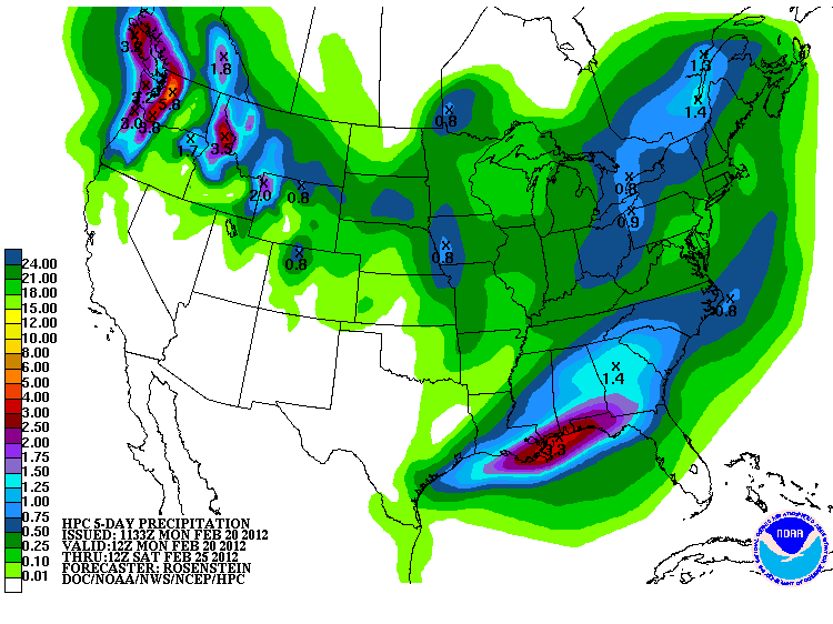
Unfortunately, there will not be much moisture for the dryline's passage so
rain totals will be limited, and the latest 5-day precipitation forecast from
the NWS' Hydrometeorological Prediction Center indicates fairly dry weather
through Saturday morning.
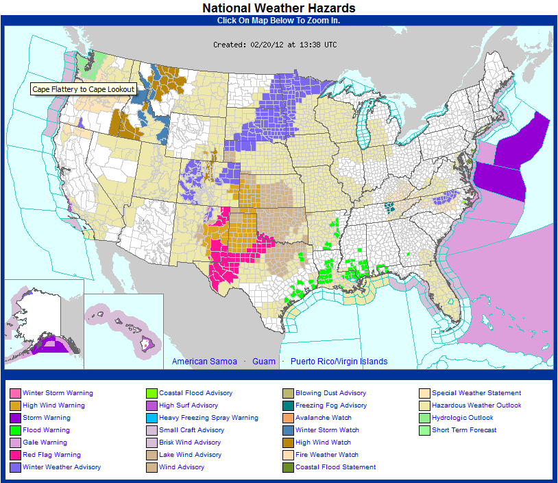
The storm system results in a nicely-colored but nasty advisory map from the
NWS. They have a wind advisory for most of the state with gusts of 45-55 mph
expected; a Red Flag Fire warning for far southwest Oklahoma where the strong
winds, low relative humidity and temperatures in the upper 60s will create
critical fire conditions later this afternoon; and finally a high wind warning
in the eastern Oklahoma Panhandle. A high wind warning is like a wind advisory
on steroids with severe thunderstorm strength winds expected (without the
thunderstorms).
For fun today in between losing your shingles and watching your fence blow down,
keep an eye on the Oklahoma Mesonet's severe wind tracker located here:
http://www.mesonet.org/index.php/weather/severe_winds
You can set the threshold for it to track. You can already see that winds are
quite strong across western Oklahoma.
******************************************************
The latest outlooks for March and the March-May three-month period from the
NWS' Climate Prediction Center are all full of orange on the temperature side.
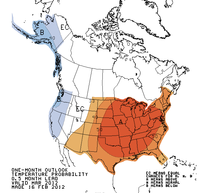

Most of the eastern half of the U.S. is pinged in a similar way. That's a
strong indication the CPC forecasters view of increased odds of above normal
temperatures east of the Rockies, due partly to the lingering effects of a
diminishing La Nina event.
As we approach the warm season, the impacts of that La Nina will become less,
well...impactful, regardless of its strength. That is normally the case. As
we've discussed before, the impacts of La Nina are much more dominant for our
part of the world in the cool season (and even more dominant as you go farther
south).
The precipitation outlook is a reflection of that, with the punt-the-forecast
"EC" over all but far western Oklahoma. The skill to adjust the odds of above-
or below-normal (or even near-normal) precipitation is simply not there. For
the Panhandle, a slight increase in the odds of below normal precipitation for
March through May is indicated, again based largely on the composites of past
La Nina events.
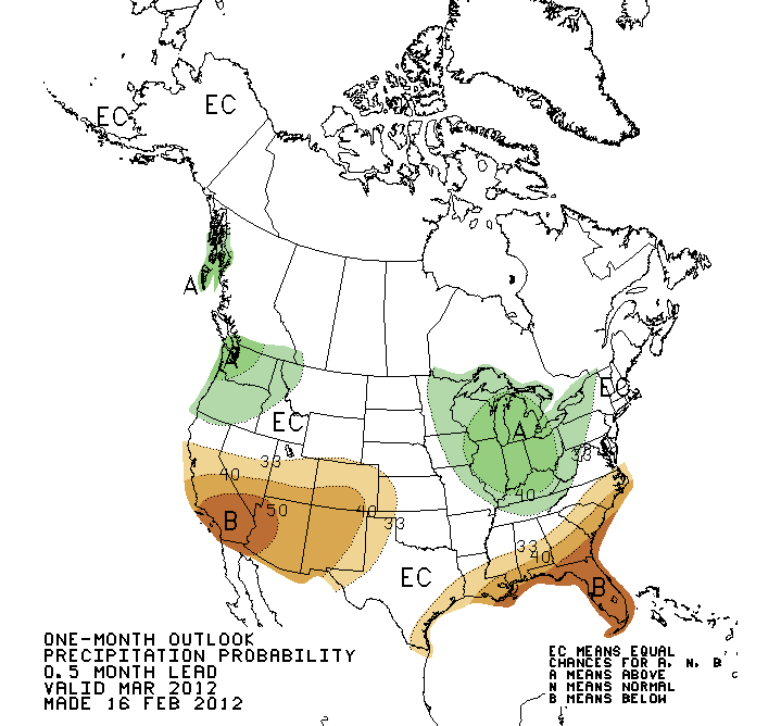
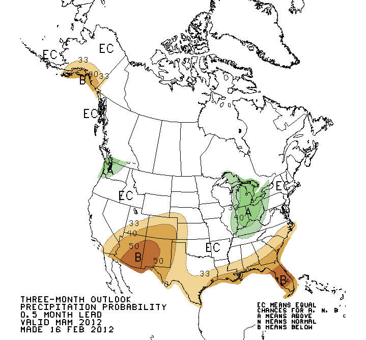
Just a reminder, in a screaming kind of way: THE WHITE "EC" AREA IS NOT AN
OUTLOOK FOR NORMAL PRECIPITATION! It's an indication of lack of skill, and that
all three possibilities are equally likely. At least in the forecaster's view.
As I've noted before, my hairline forces me to believe in complete transparency,
so here's a note about these outlooks. As we approach the warm season, their
skill, which is already less than great, decreases quite a bit. The skill is
at its highest during the cool season within an ENSO event, La Nina or El Nino.
There is some increased skill for temperature along the southern tier of states
in the warm season with the presence of La Nina or El Nino. So with the warm
season approaching AND the ENSO phase headed away from La Nina to ENSO-neutral,
enjoy (or not) the outlook maps while you can.
Gary McManus
Associate State Climatologist
Oklahoma Climatological Survey
(405) 325-2253
gmcmanus@mesonet.org
February 20 in Mesonet History
| Record | Value | Station | Year |
|---|---|---|---|
| Maximum Temperature | 86°F | ALTU | 2016 |
| Minimum Temperature | 4°F | KENT | 2006 |
| Maximum Rainfall | 4.01″ | SALL | 1997 |
Mesonet records begin in 1994.
Search by Date
If you're a bit off, don't worry, because just like horseshoes, “almost” counts on the Ticker website!