Ticker for June 12, 2014
MESONET TICKER ... MESONET TICKER ... MESONET TICKER ... MESONET TICKER ...
June 12, 2014 June 12, 2014 June 12, 2014 June 12, 2014
Mesoscale Convective madness
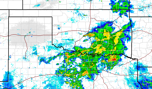
As expected, another Mesoscale Convective System (MCS) formed over Oklahoma last
night from storms that fired in the High Plains of eastern Colorado and the OK
Panhandle area. As I type this, it is still raining in Moore as storms continue
to form and train over the area again and again. That's how you really ramp up
those rainfall totals and get localized flooding. As it starts to dwindle, areas
to the south and east of central Oklahoma will continue to get theirs.
As I came back in from checking my rain gauge, I quickly ascertained two rather
large mistakes in my methodology:
1. I should have waited until it stopped raining
2. I should have, at some point, installed a rain gauge on my property
Okay, so with the lack of a rain gauge and a water-logged brain, I thought to
myself, "there has to be a better way!" If only we had some sort of mesoscale
weather monitoring network that could take advantage of mesoscale-ish spacing
between stations to observe these rainfall totals. And hey, why not throw in
some radar/gauge estimated amounts in between these gauges, like at my house?
Oh yes, the MESONET! How silly of me. Here's the rainfall map for last night's
rainfall only, Vasily (come on, "The Hunt For Red October" anyone??).
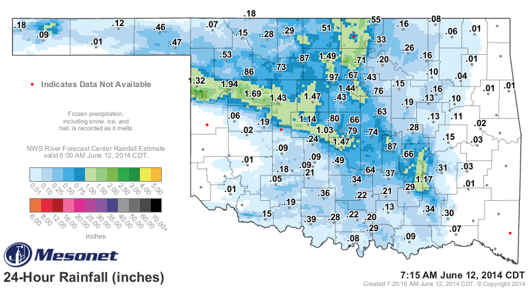
A rather nice swath of 1-2 inch amounts from Ellis County (which has been
desperately dry) through the Moore/Norman area, as well as points North up
around Stillwater through Blackwell.
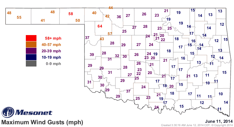
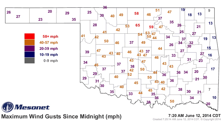
And as you'll often see with one of these MCS dealies that forms into a bow
echo, you can get some strong winds as well. Check out the maximum gust maps
from yesterday (for the storms moving through the northwest) and today thus
far (for the storms as they moved farther to the SE) and you can find quite a
few 45-60 mph gusts. Looks like Woodward wins the prize with a 64 mph gust
last night.
We did an extensive look at the rainfall in yesterday's Ticker, especially
the differences between Jan 1-May 20 and May 21-June 10:
http://ticker.mesonet.org/select.php?mo=06&da=12&yr=2014
But now I guess we can update those maps for the "since May 21st period." This
will be through this morning, so fairly up-to-the-minute.
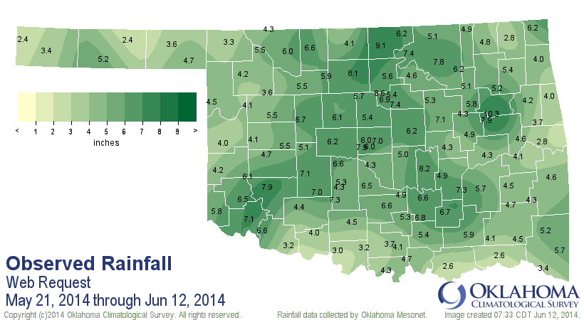
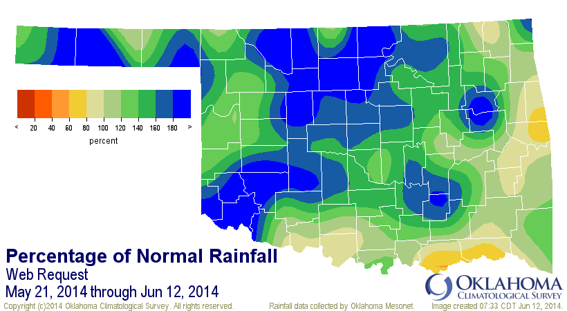
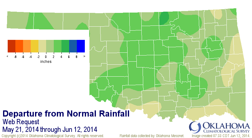
Still the 16th wettest period statewide with an average of 5.20 inches, 1.73
inches above normal (or about 150% of normal), but you can see from the
departure map that some areas are 2-4 inches above normal.
Over the longer term, we still see some significant deficits across the state
with a lot of ground to make up. Check out the year-to-date maps.
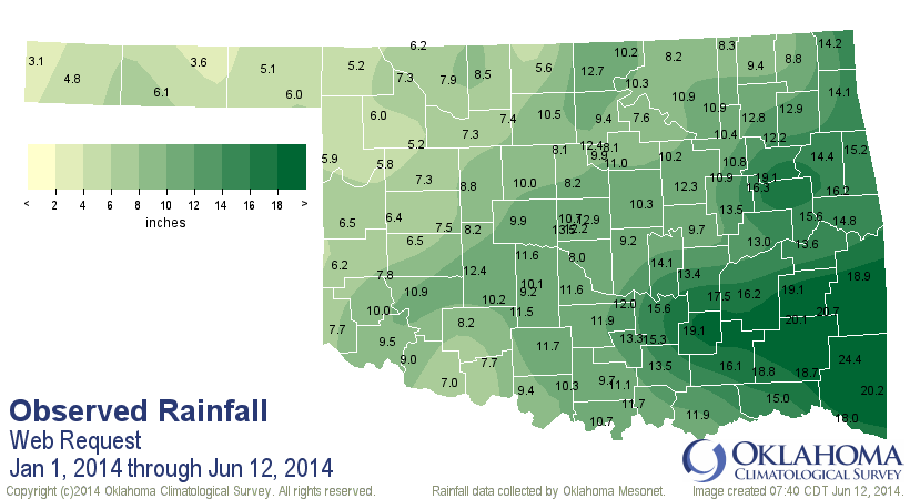

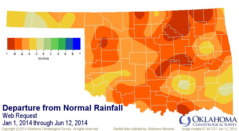
So the year-to-date period is still the 7th driest since at least 1921 with a
statewide average of 10.76 inches, 5.49 inches below normal (about 66% of
normal). So we have a battle of drought impacts going on right now between
short-term improvements (upper soil moisture, greenness, stream flows, etc.) and
long term impairments (reservoir levels, deeper soil moisture, etc.).
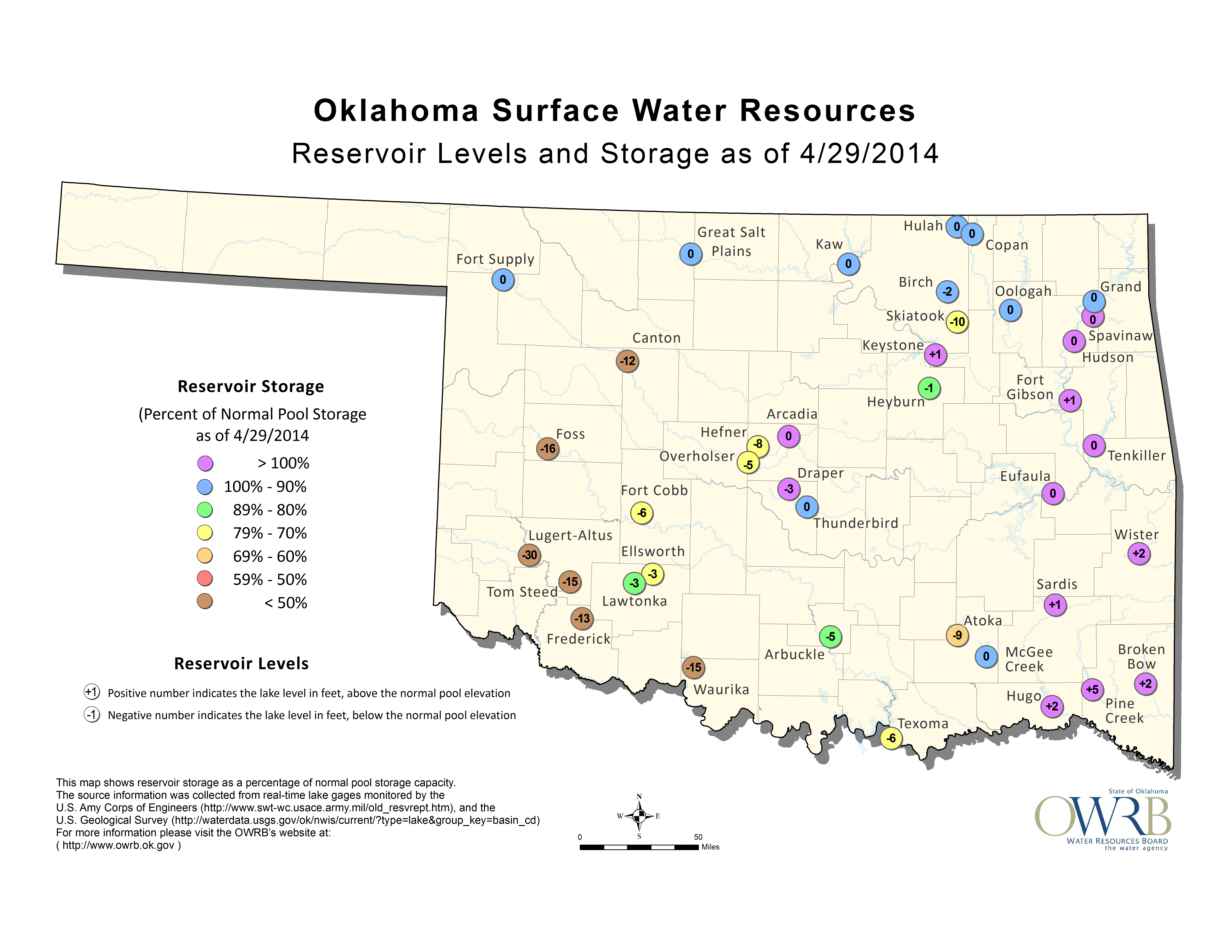
Take the lake levels. The last time I checked on the lake levels on a statewide
basis was April 29. You can see the desperation across those western lakes (and
a few other areas, like Skiatook and Texoma) on that reservoir storage map from
the Oklahoma Water Resources Board (OWRB). And then look at OWRB's map on
June 9.
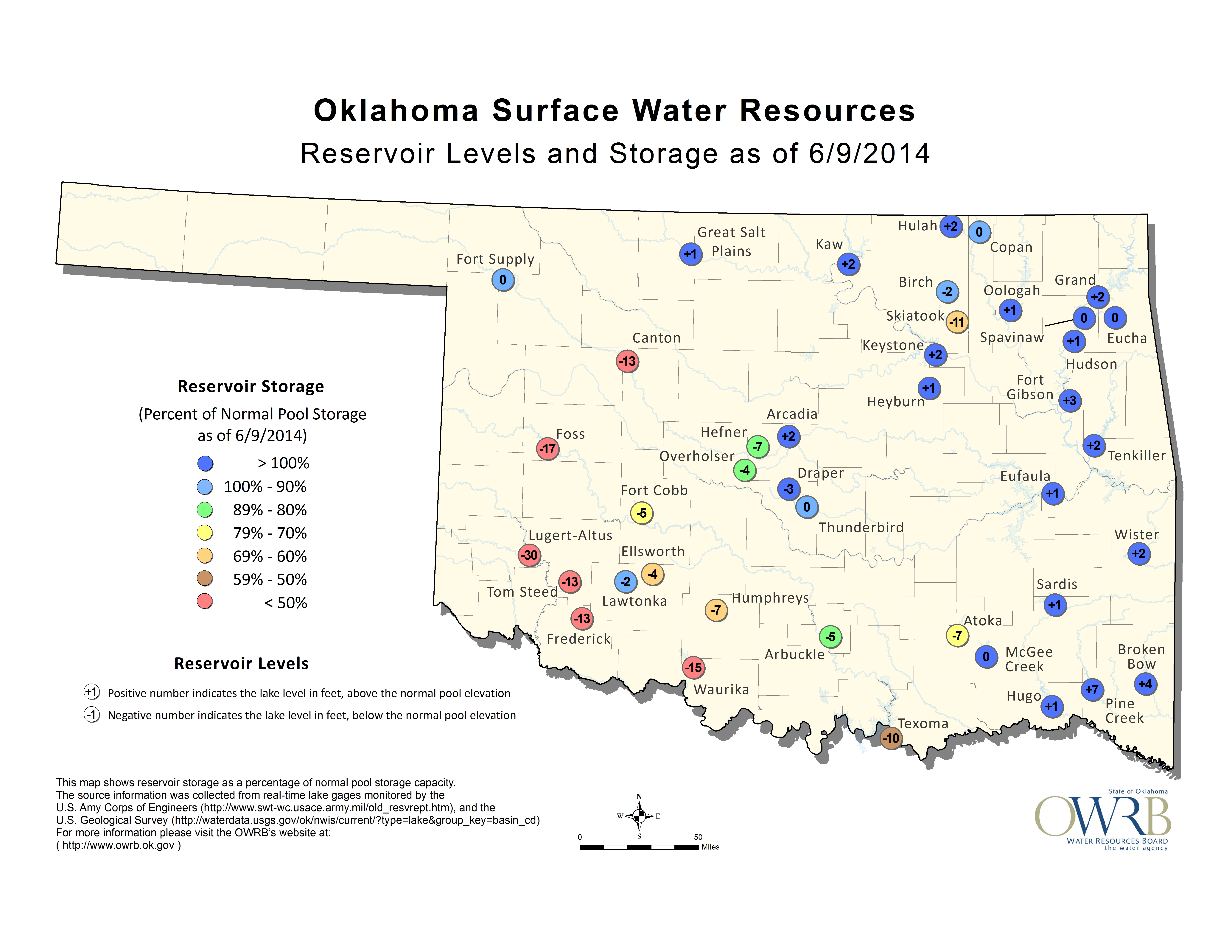
Some decent improvements across several lakes scattered about the state, even
in western Oklahoma. Tom Steed in particular has gone from about 20% of normal
capacity to 30% (or from 15 feet down to about 13 feet down), narrowly escaping
their Category 4 water restriction plan in Altus. Meanwhile, other communities
are still seeing some fairly desperate situations, such as what is going on in
the town of Pawnee.
http://tinyurl.com/pawnee-water-emergency
So yes, despite last night's rainfall (and the previous 23 days worth), there
is still a drought. We've definitely seen those short-term improvements and
even some reduction in the long-term impacts, but the U.S. Drought Monitor map
still has way too much maroon and red for my taste.
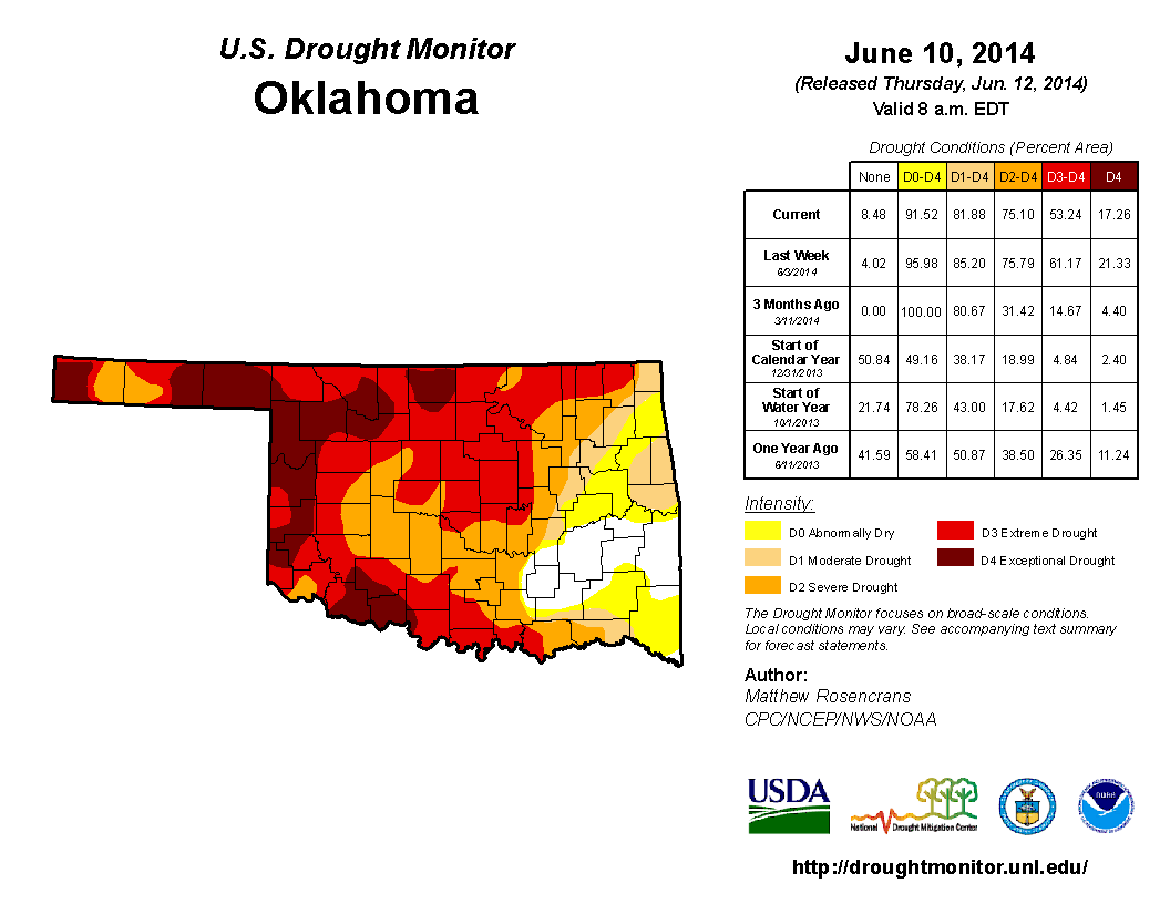
Still, what you see is a greatly improved map over what we saw just a few weeks
ago. A lot of that Extreme (D3) to Exceptional (D4) drought has been eroded
across central and western Oklahoma, and even parts of the Panhandle are now
down into the Severe (D2) category. By the way, you know things were bad when
you're cheering for Severe drought!
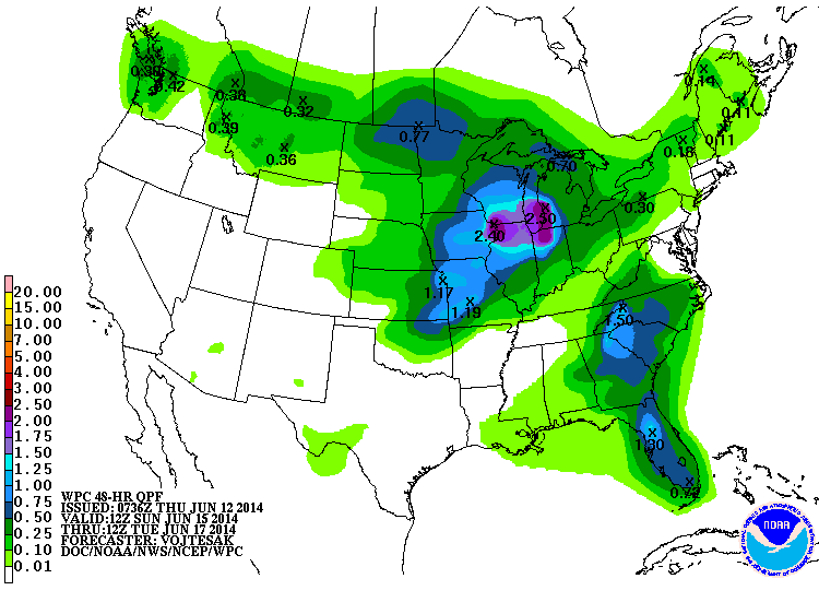
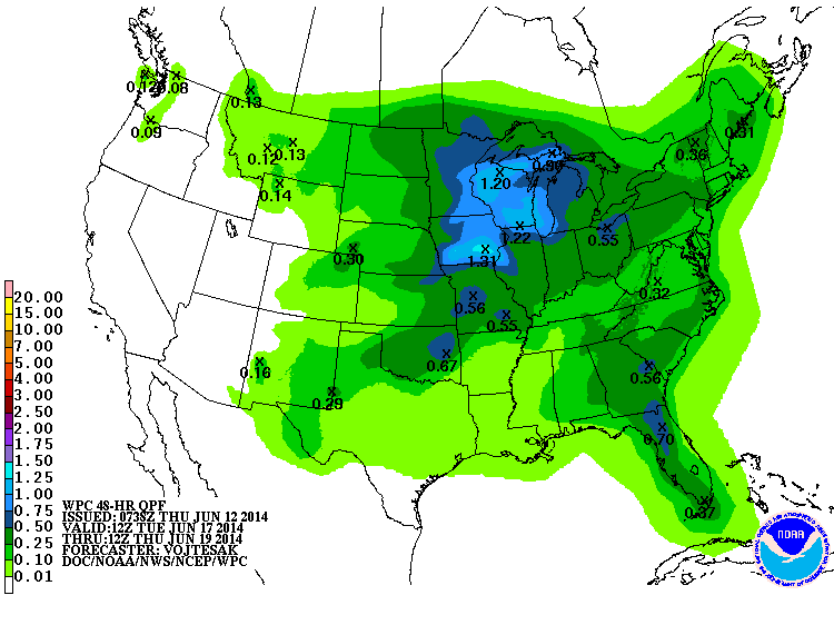
Even better news, more rain chances are showing up for this weekend and also
next week. Here are the rainfall total forecasts for next Sunday-Tuesday and
then Tuesday-Thursday.
Summer's right around the corner so everything we can get now is gravy, as we
say here in Okie-land. A very runny and bland gravy, being plain water, that
will make your chicken fried steak a bit soggy, but we'll eat it anyway.
And remember, things could always be worse. I mean, you could be forecasting
for this guy!
http://tinyurl.com/north-korea-forecasters
"He called on the service to rapidly and kindly provide information about
weather's influence upon the people's life, health, transport, etc. in diverse
methods."
"Kindly???" I'm betting those forecasters are hoping that works both ways if
they blow a forecast!
Gary McManus
State Climatologist
Oklahoma Mesonet
Oklahoma Climatological Survey
(405) 325-2253
gmcmanus@mesonet.org
June 12 in Mesonet History
| Record | Value | Station | Year |
|---|---|---|---|
| Maximum Temperature | 110°F | ALTU | 2022 |
| Minimum Temperature | 44°F | KENT | 2011 |
| Maximum Rainfall | 6.15 inches | ACME | 2016 |
Mesonet records begin in 1994.
Search by Date
If you're a bit off, don't worry, because just like horseshoes, “almost” counts on the Ticker website!