Ticker for May 11, 2015
MESONET TICKER ... MESONET TICKER ... MESONET TICKER ... MESONET TICKER ...
May 11, 2015 May 11, 2015 May 11, 2015 May 11, 2015
Biblical proportions

I'm not even going to ask you this time. Yes, we've had enough. Even for those
folks out west with lakes that were down around 10% of capacity ("were" being the
key word there), they're probably waving the white flag, at least for a couple
of days. I don't even know where to begin describing this rain, but obviously
it has been a drought ender and/or denter, depending on where you're at. Just take
a look at the Mesonet rainfall maps for the last 7, 14 and 30 days.
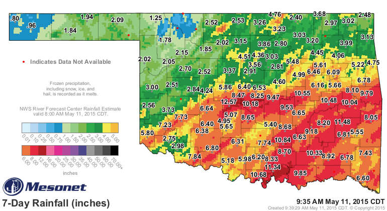
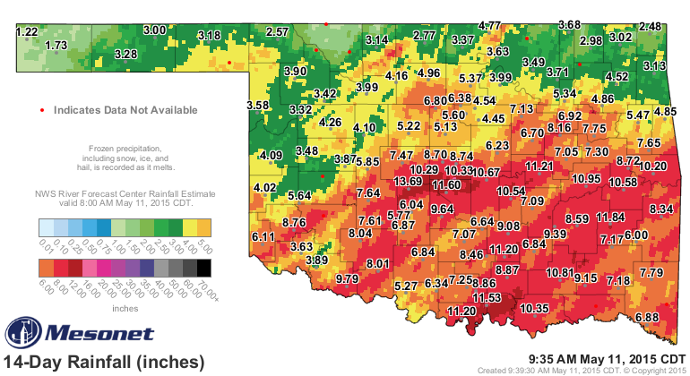
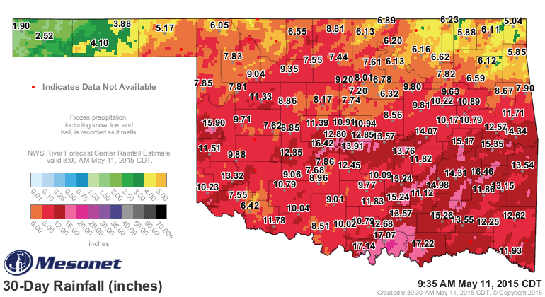
At 30 days, poor Cheyenne out in Roger Mills County, once so proud of their 14+
inches of rainfall in a couple of weeks, has been surpassed by several locations
across central and south central Oklahoma. Looks like Durant has taken the
lead at 30 days with 17.22 inches, but Minco is a close second at 16.42 inches.
Now we also have to recognize that some areas have not been so fortunate. Far
NE OK as well as some parts of NW and the Panhandle have ONLY received 5-6 inches
(2-3 inches for the Panhandle).
Now let's look at how some of this rain stacks up historically. And remember,
with these maps, we're just using the Mesonet gauge data...the radar-gauge
estimated data isn't included. Let's start with April 1 through this morning,
since that's really when all this drought relief of some sort or another started
in earnest. Actually it started in Cheyenne, but you know what I mean.
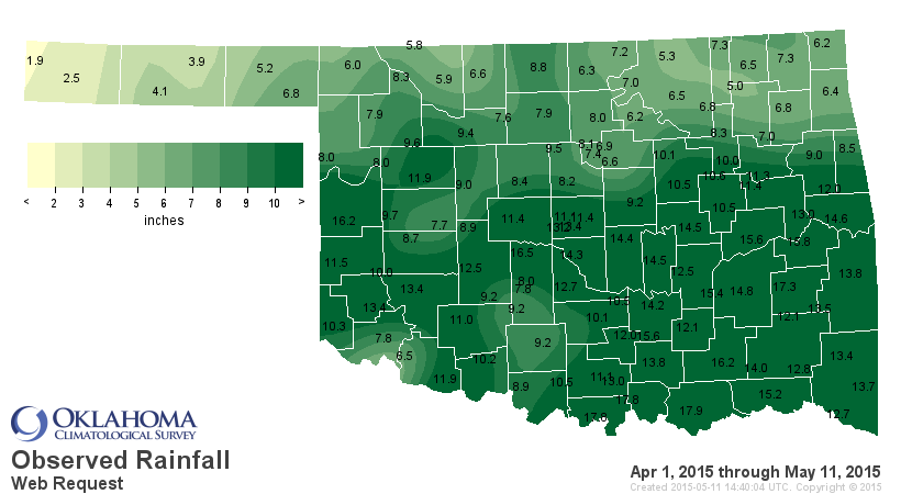
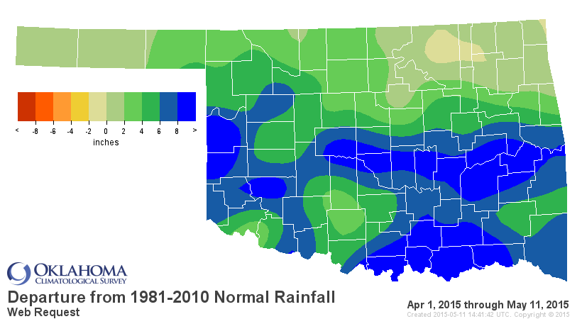
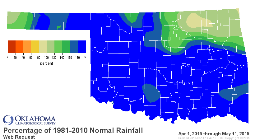
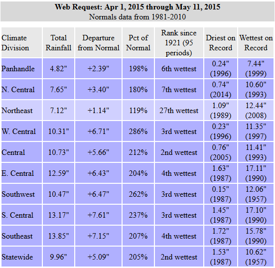
So the statewide average since April 1 is 9.96", 5.1 inches above normal and the
2nd wettest such period since at least 1921. And that is significant since it
is occurring during the west season. You get the 2nd wettest winter Jan. 1-Feb.
11 on record and that would also be significant, but THIS is the time of year
when that really matters. This is the time of year when we need that rainfall
and can get ahead of the demands and still eradicate drought.
Now that we're into May, the REAL wet season (basically our wettest part of the
year runs from early May through about mid-June), high-ranking rainfalls matter
even more (again).
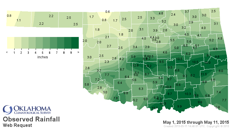
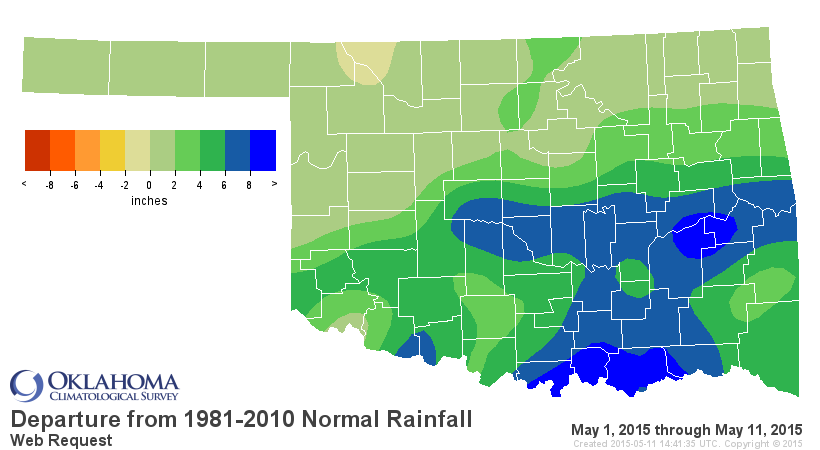
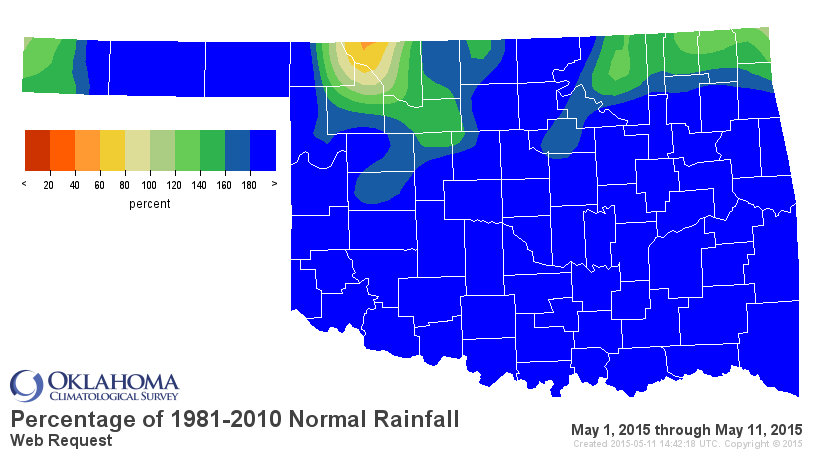
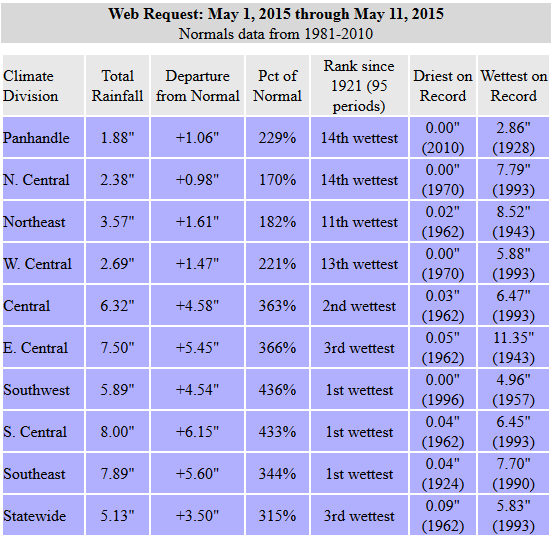
WOW again! The statewide average for May 1-11 is 5.13 inches, 3.5 inches above
normal and the 3rd wettest such period since at least 1921. And for the SW, SC
and SE part of the state, THE wettest such period since 1921. That's how you
end (or put a heckuva dent) in drought.
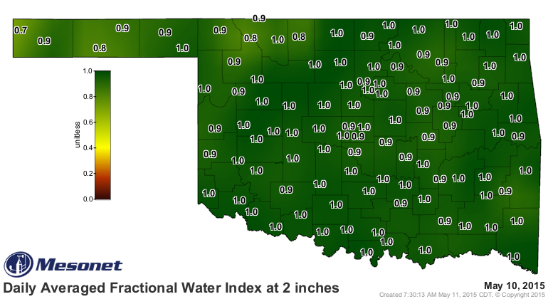
Short-term impacts are over, basically. No more fire danger, no more dry
topsoils, medium-depth soils are saturated. Even the lower depths are mostly
saturated, so there we start alleviating the long-term impacts.
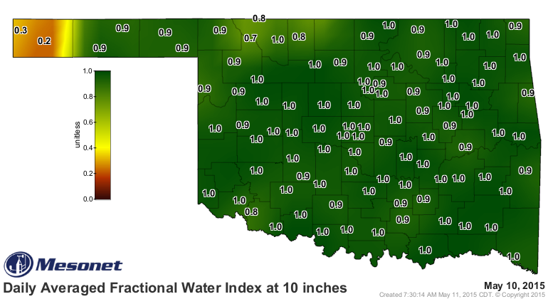
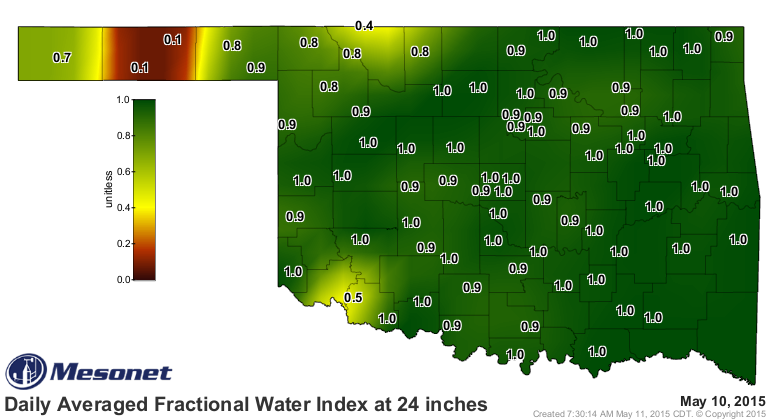
The western OK lakes have responded:
Altus-Lugert: 32% and still rising
Tom Steed: 42% and still rising (this is the Altus drinking water supply)
Foss: 43% and still rising
Waurika: 41% and rising fast
Canton: 30% and rising incrementally
Canton is a bit disappointing, but it has a smaller watershed and also it hasn't
rained across it to the NW as much, so less water flowing in. But it is rising
in fits and spurts nevertheless. Skiatook Lake up in Osage County is finally
responding to precip and has come up a couple of feet to 58% of capacity. Still
a long way to go on some of those lakes, but the fact that they are responding
to the rains is what matters. You can completely eradicate drought and still
have a lake at 50% of capacity as long as it is responding to rain.
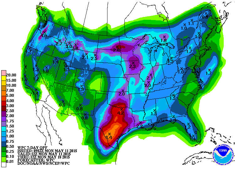
And the rain ain't over yet. There is still the chance for bigtime rains
coming up on Wednesday and then into the weekend. I'm not sure southern Oklahoma
needs another 3-4 inches of rain, but it's painted on the map!
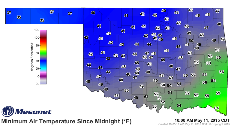
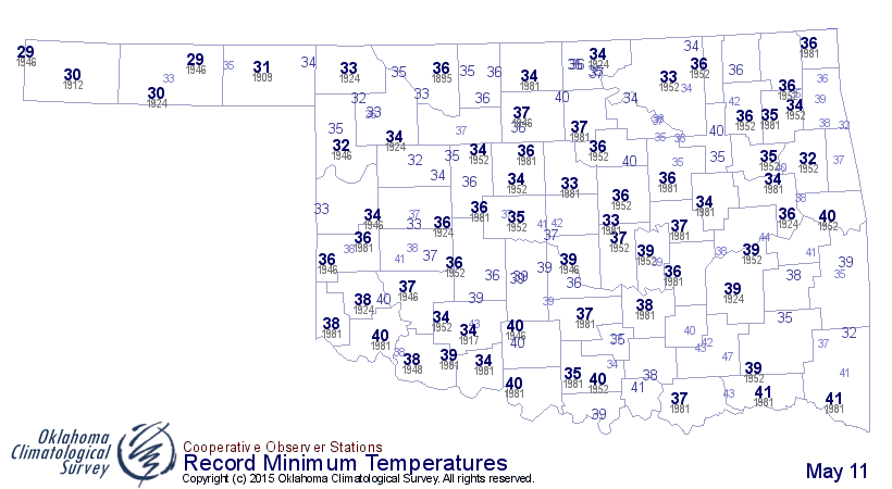
Last and worst, it was cold this morning for it being May 11th! COLD! Check out
the minimum wind chill map from the Mesonet.
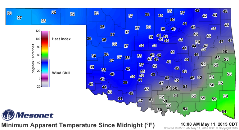
20sk 30s and 40s? ARE YOU KIDDING ME PRIVATE PYLE? That's ridiculous. The morning
lows weren't much better. These aren't too far off of record lows for the day.
A month ago, I never thought I would have been saying this, but enjoy these
rain-free days today and tomorrow. We really need a break!
Gary McManus
State Climatologist
Oklahoma Mesonet
Oklahoma Climatological Survey
(405) 325-2253
gmcmanus@mesonet.org
May 11 in Mesonet History
| Record | Value | Station | Year |
|---|---|---|---|
| Maximum Temperature | 106°F | ALTU | 2000 |
| Minimum Temperature | 30°F | BOIS | 2008 |
| Maximum Rainfall | 5.87 inches | HUGO | 1999 |
Mesonet records begin in 1994.
Search by Date
If you're a bit off, don't worry, because just like horseshoes, “almost” counts on the Ticker website!