Ticker for December 29, 2014
MESONET TICKER ... MESONET TICKER ... MESONET TICKER ... MESONET TICKER ...
December 29, 2014 December 29, 2014 December 29, 2014 December 29, 2014
The excitingly boring weather of 2014
It's hard to look past the coming arctic blast to end 2014 to look BACK at the
past weather of 2014, so let's get the future excitement out of the way first.
Okay, to start off with, since freezing rain has mentioned, we are officially
moving the BRAUM'S BREAD-AND-MILK DEFCON LEVEL to THREE!!! I repeat, we are
officially moving the BRAUM'S BREAD-AND-MILK DEFCON LEVEL to TWO!! (see how
quickly we react here with up-to-the-minute hysteria??)

Yes, we've gone to "KNOCK PEOPLE OVER IF YOU HAVE TO" level. Mostly bombastic
and reactionary, of course, but just our effort to try and keep folks from
driving on ice (DISCLAIMER: should ice occur).
Here is the setup as provided in pictures from the local NWS offices.
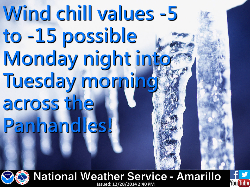


Remember, this is winter weather we're talking, so the forecast is going to
change between now and ICE-MAGEDDON. So keep track of the changing conditions
as we get closer because the precipitation type is vitally important. However,
the arctic blast is a certainty.
The beast is poised to our north as we speak.

So prepare for this, because it's coming.

I'm afraid there won't be any melting on the roads with this coming system.
Okay, enough hysteria. Let's turn back the clock and take a look back at 2014.
Enjoy.
-------------------------------------------------------------------------------
The weather of 2014 would probably be considered boring by most, and rightfully
so. After all, there were no EF-5 twisters ravaging the countryside, nor was
there a never ending onslaught of days with triple-digit heat. The blizzards
of the last few years never materialized, nor did that other unwelcome winter
visitor, the ice storm. What we did have, however, was drought, the most boring
? if not most damaging ? of Oklahoma's weather hazards. That particular guest
has been plaguing Oklahoma's ecosystem, agriculture and economy since its
beginning in late fall 2010 to the tune of several billion dollars in damage.
The spring rainy season was mostly a bust, although a return of moisture in
late May paved the way for more rain during June and July. That
uncharacteristically timed relief delayed the re-intensification of drought
that started earlier in the year, but more dry stretches from August forward
left over 60 percent of the state in drought at year's end. The year ended with
a dark, dank and dreary December in which the sun was mostly a no-show at only
35.4 percent of possible sunshine according to the Oklahoma Mesonet's solar
radiation sensors.
In the end, 2014 left us with memories of a (mostly) cold and (mostly) dry
year, with a few bursts of excitement to satisfy most weather enthusiasts. Here
are a few or the more notable weather highlights (or lowlights) from 2014, as
well as the top extremes as measured by the Oklahoma Mesonet.
2104 Oklahoma Weather Highlights
? According to preliminary data from the National Weather Service (NWS), 2014
ended up with a total of 16 tornadoes, the lowest count since accurate
records began in 1950. That bests the previous minimum annual twister count
of 17 back in 1988. That stands in stark contrast to recent years that ranked
near the top for annual tornado totals. The record of 145 is still held by
1999, but 2011 and 2010 rank with the second- and fourth-highest totals at
119 and 103, respectively. And 2013 tied for ninth highest at 82. The annual
average tornado total for Oklahoma is approximately 56.
o The strongest 2014 tornado listed was an EF-2 that struck the small
town of Quapaw in Ottawa County, killing one and heavily damaging as
many as 50 structures.
o A tornado touched down near Lake Arcadia in central Oklahoma on the
December 14, only the 25th tornado since 1950 for that month.
o Of the 16 confirmed tornadoes, 11 were of the weakest rating of EF-0.
o Although not associated with a tornado, a thunderstorm near Burneyville
on July 30th produced a wind gust of 106 mph, tied for the fourth highest
in Mesonet history.
? According to preliminary data from the Oklahoma Mesonet through December 28,
the statewide average precipitation total for the year thus far was 28.56
inches, 7.74 inches below normal. Depending on what possible precipitation
falls in year's final three days, it is estimated that 2014 will rank
somewhere from 25th to 30th driest since 1895 (note: the rankings in the
statistics table below are since 1921).
o The Mesonet site at Kenton recorded 13.2 inches of precipitation during
2014, the lowest such total in the state. Broken Bow and Clayton led the
state with 50.8 inches each.


o The spring (March-May) rainy season was the 11th driest on record with a
statewide average of 6.57 inches, more than 5 inches below normal.


o The January-May statewide average was 7.39 inches, the 3rd driest first
five months of the year on record.
o June and July combined were the 15th wettest on record across Oklahoma
with an average of 10.28 inches, nearly 3.5 inches above normal.


? A no-show summer and a frigid first few months of the year guaranteed a cool
2014, and the statistics back that up. Preliminary data from the Oklahoma
Mesonet place the statewide average temperature for 2014 at 58.9 degrees,
about a degree below normal. Depending on what occurs the last few days of
the year, that would rank 2014's temperature somewhere in the 20-30th coolest
on record range. Interestingly, 2013's final statewide temperature also
finished at 58.9 degrees.
o Summer itself was the 24th coolest on record with a statewide average of
78.6 degrees, 1.1 degrees below normal.
o July was the fifth coolest on record and 4.3 degrees below normal.
o A brush with frigid weather in the middle of November proved to be one of
the most significant early-season winter outbreaks on record for Oklahoma.
The cold snap began with a cold front on the 11th that dropped
temperatures from the 70s and 80s into the 30s and 40s. The Oklahoma
Mesonet station at Boise City struggled to a high of 15 degrees on the
12th just two days after reaching a high of 81 degrees. Most of the state
had spent from 100 to more than 150 hours below freezing. The event also
came with a statewide blanket of snow. Amounts of 3-4 inches were common
across parts of western, northern and central Oklahoma.
o December finished the year off with one last warm month, but not in the
way one would normally think. There were very few pleasantly warm
afternoons, as daytime highs were actually a bit below normal. The morning
lows, however, were another story. Through the 29th, the statewide average
low temperature was 35.2 degrees, 7.7 degrees above normal. Overall, the
statewide average through the 29th was 3.4 degrees above normal. The last
two days of December promised to be quite chilly, however, which could
bring that average down just a bit.
-------------------------------------------------------------------------------
The 2014 Oklahoma Mesonet extremes
----------------------------------
Temperature
----------------------------------
Maximum Air Temperature
FREEDOM 106.9 F 07/26/2014
Minimum Air Temperature
NOWATA -12.1 F 01/06/2014
Maximum Heat Index
LANE 112.6 F 08/08/2014
Minimum Wind Chill
ALVA -25.0 F 01/06/2014
Greatest 1-hour Temperature Change
KENTON 32.9 F (80.6 F 11/10/2014 21:55 to 47.7 F 11/10/2014 22:50)
Greatest 24-hour Temperature Change
SLAPOUT 66.2 F (84.6 F 11/10/2014 20:40 to 18.3 F 11/11/2014 13:15)
----------------------------------
Humidity
----------------------------------
Highest Dew Point Temperature
BROKEN BOW 81.3 F 07/27/2014
Lowest Dew Point Temperature
MIAMI -18.8 F 01/06/2014
----------------------------------
Rainfall
----------------------------------
Greatest 1-hour Rainfall
HINTON 3.07" 06/19/2014
Greatest 24-hour Rainfall
CLAYTON 6.60" (07/30/2014 - 07/31/2014)
----------------------------------
Wind Speed
----------------------------------
Maximum Wind Speed (5-minute average)
BEAVER 59.7 mph 07/01/2014
Maximum Wind Gust
BURNEYVILLE 105.8 mph 07/31/2014
----------------------------------
Pressure
----------------------------------
Highest Mean Sea Level Pressure
CHEROKEE 1044.55 mb 01/23/2014
Lowest Mean Sea Level Pressure
MAY RANCH 989.17 mb 04/27/2014
Gary McManus
State Climatologist
Oklahoma Mesonet
Oklahoma Climatological Survey
(405) 325-2253
gmcmanus@mesonet.org
January 1 in Mesonet History
| Record | Value | Station | Year |
|---|---|---|---|
| Maximum Temperature | 81°F | WAUR | 2023 |
| Minimum Temperature | -7°F | EVAX | 2018 |
| Maximum Rainfall | 1.65 inches | TALI | 2022 |
Mesonet records begin in 1994.
Search by Date
If you're a bit off, don't worry, because just like horseshoes, “almost” counts on the Ticker website!