MESONET TICKER ... MESONET TICKER ... MESONET TICKER ... MESONET TICKER ...
August 8, 2011 August 8, 2011 August 8, 2011 August 8, 2011
Oklahoma July Warmest on Record for U.S.
Grover Cleveland was serving his second term as President in 1895. Victoria was
the Queen of England and Will Rogers was still a teenager. It is also the year
that statewide average temperature records begin for the United States. There
have been 1399 months pass by since 1895. Multiply that number by 48 and you
have 67,152 months of temperature records for the contiguous states. How hot
was it in Oklahoma last month? Of those statewide average temperature records
for the 48 states, none has been hotter than July 2011 in Oklahoma.
According to data from the Oklahoma Mesonet, the statewide average temperature
during July came in at 89.1 degrees, more than 7 degrees above normal. High
temperatures alone were nearly 9 degrees above normal at 102.9 degrees. The
National Climatic Data Center's statewide average for July stands at 88.9
degrees with data still being collected. Both values shattered the country?s
previous record of 88.1 degrees held by another legendary hot month in
Oklahoma, July 1954.
http://ticker.mesonet.org/archive/20110808/July_statewide_averages.png
The extreme heat is being fueled by one of the worst short-term droughts in
state history. The drought?s beginnings date back to August 2010 but
intensified beginning in the fall under the influence of La Ni?a. That climate
phenomenon, marked by cooler than normal water temperatures in the eastern
equatorial pacific, often means drier weather for the southern United States.
The statewide average precipitation total of 16.73 inches since October 1,
2010, is the driest on record at nearly 14 inches below normal. Parts of
southwestern Oklahoma have seen less than 6 inches of rain over that 10-month
period.
The loss of soil moisture and green vegetation has combined with the summer sun
to bake the state unmercifully. July was the hottest >month in Oklahoma City?s
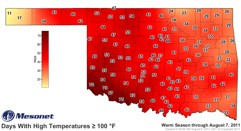
history, dating back to 1890. At 75 days through Sunday, Grandfield is quickly
approaching the state?s all-time record for days with highs above 100 degrees.
The record is 86 days, set at Hollis in the drought-fueled summer of 1956.
Unfortunately, the heat has only intensified during the first week of August.
The Mesonet has recorded a statewide average temperature of 92.1 degrees over
the month?s first seven days with an average high of 107 degrees and an average
low of 77 degrees. The state remains on course to record its warmest summer as
well. The statewide average temperature for the summer thus far is 87 degrees,
easily outpacing the current record of 85.2 degrees from 1934.
http://ticker.mesonet.org/archive/20110808/Mesonet_days_above_100.png
Unfortunately, widespread relief has yet to appear on the horizon. The latest
seasonal drought outlook from the National Weather Service?s Climate Prediction
Center (CPC) calls for drought to persist or intensify in Oklahoma through the
end of October. Farther out, the news is just as troubling. While the La Ni?a
event faded in late spring, the CPC issued a La Ni?a watch last week for
possible development once again this winter. The possibility of extending the
current drought further would be very bad news for a state already hit hard by
the heat and lack of rainfall.
Gary McManus
Associate State Climatologist
Oklahoma Climatological Survey
(405) 325-2253
gmcmanus@mesonet.org
==================================================
The OCS/Mesonet Ticker
https://ticker.mesonet.org/
To subscribe or unsubscribe from the Ticker
or for questions about the Ticker or its content
Phone or Email the Ticker Manager at OCS
Phone: 405-325-2253 Email: ticker@mesonet.org
---------------------------------------------------
-C- Copyright 2024 Oklahoma Climatological Survey
===================================================
|


 Tweet
Tweet