MESONET TICKER ... MESONET TICKER ... MESONET TICKER ... MESONET TICKER ...
November 3, 2011 November 3, 2011 November 3, 2011 November 3, 2011
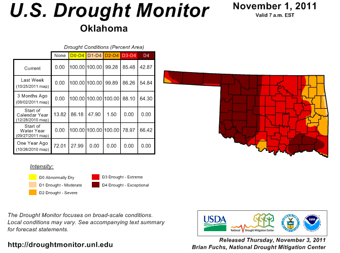
Drought Monitor depiction improves for Oklahoma
The impacts of several rain events throughout October led us to ask for more
improvements in Oklahoma's drought depiction in Oklahoma. Improvements in soil
moisture and the decreased demand (sun, vegetation,human consumption, etc.) for
the moisture that did fall led to a 12% reduction in the area covered by
D4-exceptional drought.
http://ticker.mesonet.org/archive/20111103/ok_dm.png
Most of that improvement came along and east of I-35, as well as a bit of work
with the old eraser to the west of I-35. The D2-severe drought area also nudged
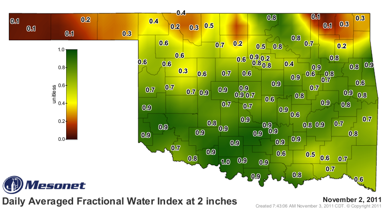
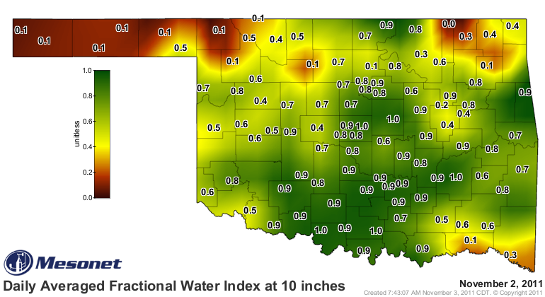
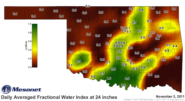
up a bit farther into Jefferson County. The improvements we are waiting for now
are the moistening of the lower soils. You can see from the Mesonet's soil
moisture data how the rains improved the top 2-10 inches of soil, but the
lower soils remain dry over much of the state.
http://ticker.mesonet.org/archive/20111103/2-inch-soilmoisture.png
http://ticker.mesonet.org/archive/20111103/10-inch-soilmoisture.png
http://ticker.mesonet.org/archive/20111103/24-inch-soilmoisture.png
Parts of the state are still lacking adequate soil moisture even in the upper
levels. From Grant County west through Cimarron County and also parts of the
extreme northeast, the moisture simply hasn't been plentiful enough. Another
area of concern is reservoir levels. We have not seen enough improvement in
that area of drought impacts, so while some impacts have improved, others are
still lagging behind. A few lake levels:
Canton -- 26% Keystone -- 74%
Thunderbird -- 73% Kaw Lake -- 93%
Eufaula -- 73% Skiatook -- 64%
Altus -- 16% Oologah -- 86%
Arbuckle -- 76% Broken Bow -- 71%
Hugo -- 56%
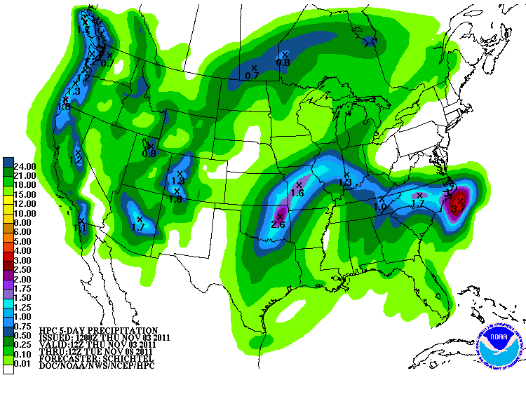
It could be worse, of course. Lake Meredith, a major water supply reservoir for
Amarillo, is at 0%. Next good chance for rain is coming early next week. The
latest prediction from the HPC shows a bullseye of 2.6 inches over in the
northeast corner of the state. We really need that to shift to the west a bit
more since western Oklahoma is depicted with a half of an inch or less. Still
lots of time for that forecast to adjust, and that only accounts for rains
through next Tuesday morning.
http://ticker.mesonet.org/archive/20111103/5-day-rainfall.gif
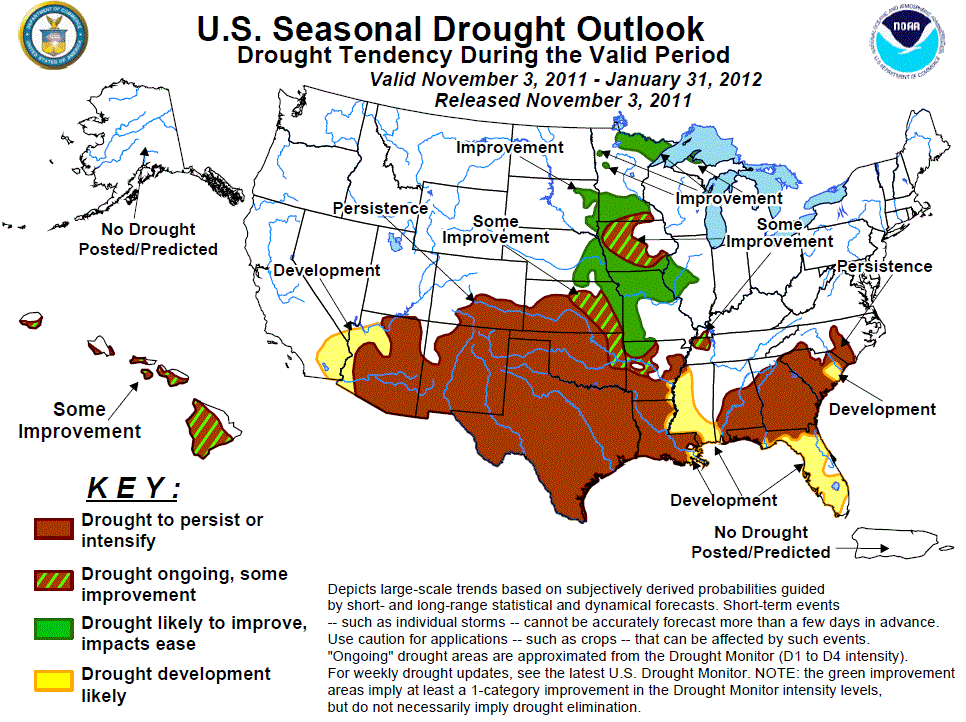
I held a bit of hope that we would see a much better Seasonal Drought Outlook
from the CPC this go-round, but unfortunately they still paint most of Oklahoma
in the "persist or intensify" area through the end of January. The northeast
does get the "ongoing, some improvement" label, so possible good news for them.
http://ticker.mesonet.org/archive/20111103/season_drought.gif
Here's the relevant text for Oklahoma from CPC forecaster Rich Tinker, who
characterizes the confidence of this outlook as "high" :
"Farther north, at least some improvement is anticipated from central
Arkansas and northeastern Oklahoma ... Meanwhile, the various tools
almost unanimously favor subnormal precipitation on all time scales
across eastern Colorado and the western halves of Oklahoma and Kansas,
where drought should persist."
He adds in a more detailed discussion later:
"Finally, the deep and protracted nature of the ongoing drought was
also considered. Deficient precipitation dates back more than a year
through this region, and shortfalls of 12 to more than 24 inches for
the current calendar year are common across many sections of Oklahoma,
Texas, and Louisiana. Given these large long-term precipitation
deficits -- and the fact that indicators valid for the bulk of the
November ? January forecast period point toward more dryness ?-
any moderate to locally heavy rains during the first half of November
should have little impact on the overall drought picture."
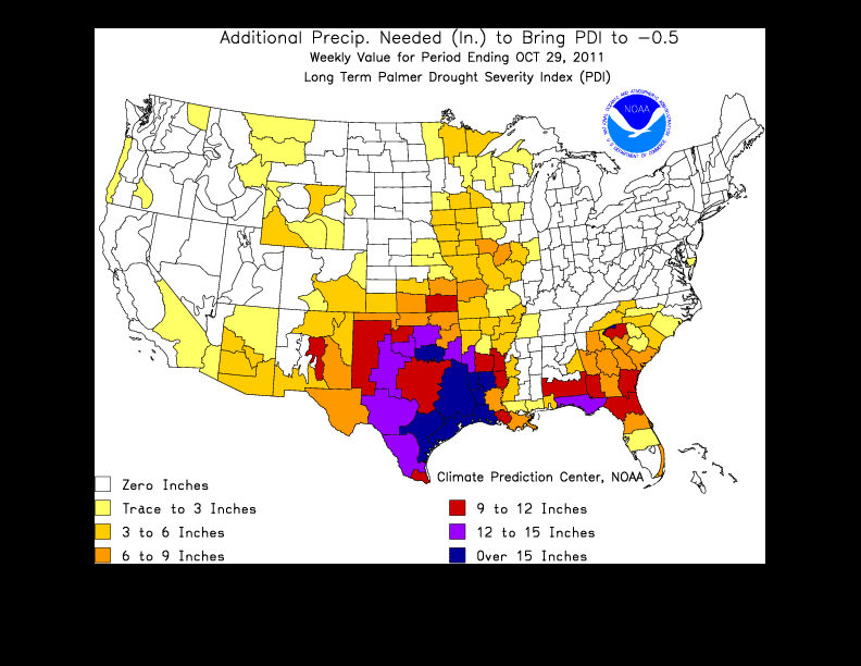
As he mentioned in that last paragraph, deficits going back a year are
significantly high. Here's a look at an approximation of how much rainfall we
would need to END the drought (note* lesser amounts would diminish impacts and
provide relief).
http://ticker.mesonet.org/archive/20111103/how-much-needed.gif
From 6-9 inches in northern Oklahoma to over 15 inches across the south central
counties. Again, just an approximation according to one drought index.
It's all up to Mother Nature to turn the tide. As we used to say at Cotter's
Oil Company back in Buffalo when gas stations were still full service: "Fill
'er up!"
And don't forget the ice cold glass bottle of Coke for 25 cents.
Gary McManus
Associate State Climatologist
Oklahoma Climatological Survey
(405) 325-2253
gmcmanus@mesonet.org
==================================================
The OCS/Mesonet Ticker
https://ticker.mesonet.org/
To subscribe or unsubscribe from the Ticker
or for questions about the Ticker or its content
Phone or Email the Ticker Manager at OCS
Phone: 405-325-2253 Email: ticker@mesonet.org
---------------------------------------------------
-C- Copyright 2024 Oklahoma Climatological Survey
===================================================
|


 Tweet
Tweet