MESONET TICKER ... MESONET TICKER ... MESONET TICKER ... MESONET TICKER ...
June 1, 2011 June 1, 2011 June 1, 2011 June 1, 2011
May 2011: Violent tornadoes, record wind speeds, record hail(??)
Even though severe weather only struck on a few days during May, those instances
gave the month more than its money?s worth. The most violent weather occurred on
May 24 when several long-track violent tornadoes tore their way through Oklahoma
from west to east. While the exact details of the twisters are still being
discovered, their 10 confirmed fatalities are unfortunately all too certain.
Those casualties make the month the deadliest due to tornadoes in Oklahoma since
May 1999. One of those deadly tornadoes clipped the Oklahoma Mesonet site
northwest of El Reno just minutes after killing five people on and north of
Interstate 40. The site?s instruments recorded a maximum wind gust of 151 mph
during the tornado?s passage. The 151 mph wind gust tops the previous Mesonet
record of 113 mph, recorded at the Lahoma site on August 17, 1994. Preliminary
reports from the National Weather Service indicate at least 27 tornadoes
touched down during May along with dozens of reports of golf ball- to
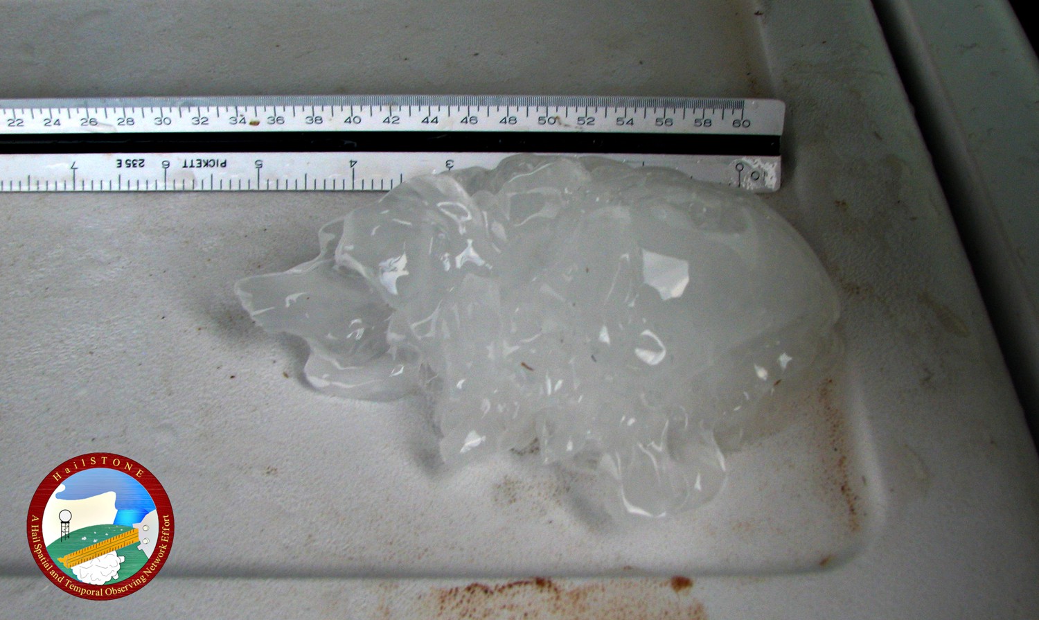
softball-size hail. A National Weather Service research team from Topeka
measured a 6-inch diameter hailstone near Gotebo on May 23, one of the largest
stones ever reported in Oklahoma (for more information on the project that
produced this picture, scroll to the bottom of the page).
http://ticker.mesonet.org/archive/20110601/gotebo_6-inch_hail.jpg
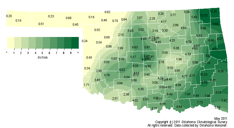
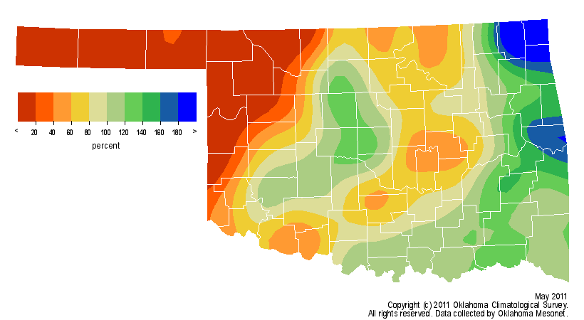
The other big weather story during May was the continuing drought in far
western Oklahoma versus the excessively wet weather in the east. Much of the
northwestern one-quarter of the state saw less than a half-inch of rain while
the eastern one-third received 6-10 inches. Oklahoma City experienced its 13th
wettest May since 1890 with 9.21 inches, a surplus of 3.77 inches. The extremes
evened out for a statewide average of 4.37 inches, the 51st driest May since
records began in 1895 at less than an inch below normal. The statewide average
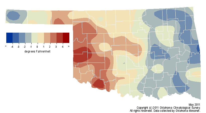
temperature was near normal at 67.8 degrees, the 55th coolest May on record.
http://ticker.mesonet.org/archive/20110601/totrain.png
http://ticker.mesonet.org/archive/20110601/pctrain.png
http://ticker.mesonet.org/archive/20110601/avgtavg.png
http://ticker.mesonet.org/archive/20110601/deltavg.png
The contrast in moisture from west to east is exemplified by comparing the
weather fortunes of the northwest and southeast corners of the state. The
Panhandle received an average of 0.33 inches during May, more than 3 inches
below normal with a rank of fourth driest on record. Meanwhile, the southeast
enjoyed a surplus of more than an inch at 7.71 inches, the 29th wettest May in
that area. The Mesonet site at Vinita led the state?s rainfall totals with
12.52 inches. Boise City and Buffalo ended up at the other end of the gauge
with totals of 0.19 inches. Grandfield was the warmest site in the state with
an average temperature of 73.7 degrees and Boise City came in an unsurprising
last with 60.6 degrees. The highest temperature of the month was 108 degrees at
Altus on the 27th. The lowest temperature of 26 degrees was recorded at Boise
City on the second.
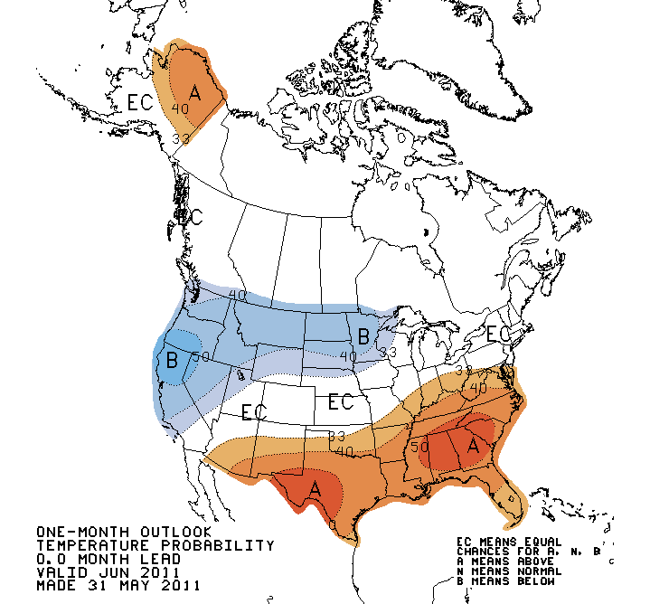
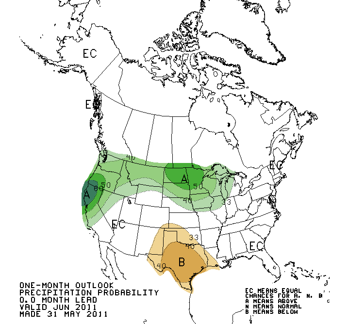
The outlooks for June from the National Weather Service?s Climate Prediction
Center indicate an increased chance for above normal temperatures in the
southern two-thirds of the state and an increased chance for below normal
precipitation in the southwestern two-thirds, including the Oklahoma Panhandle.
http://ticker.mesonet.org/archive/20110601/june_temp_outlook.gif
http://ticker.mesonet.org/archive/20110601/june_precip_outlook.gif
Gary McManus
Associate State Climatologist
Oklahoma Climatological Survey
(405) 325-2253
gmcmanus@mesonet.org
**********************************************************************
HailSTONE is a collaborative grassroots research effort among
meteorologists and experienced storm chasers in the field to
investigate large hail in space and time through direct mobile
measurements. This ambitious coordinated project will produce
some of the highest resolution hail data ever collected, providing
a rare glimpse into the true hail-fall character of convective
storms, and allowing for a meaningful bridge from research to
operations.
HailSTONE Principal Investigators
-Scott Blair
-Derek Deroche
**********************************************************************
==================================================
The OCS/Mesonet Ticker
https://ticker.mesonet.org/
To subscribe or unsubscribe from the Ticker
or for questions about the Ticker or its content
Phone or Email the Ticker Manager at OCS
Phone: 405-325-2253 Email: ticker@mesonet.org
---------------------------------------------------
-C- Copyright 2024 Oklahoma Climatological Survey
===================================================
|


 Tweet
Tweet