MESONET TICKER ... MESONET TICKER ... MESONET TICKER ... MESONET TICKER ...
March 1, 2023 March 1, 2023 March 1, 2023 March 1, 2023
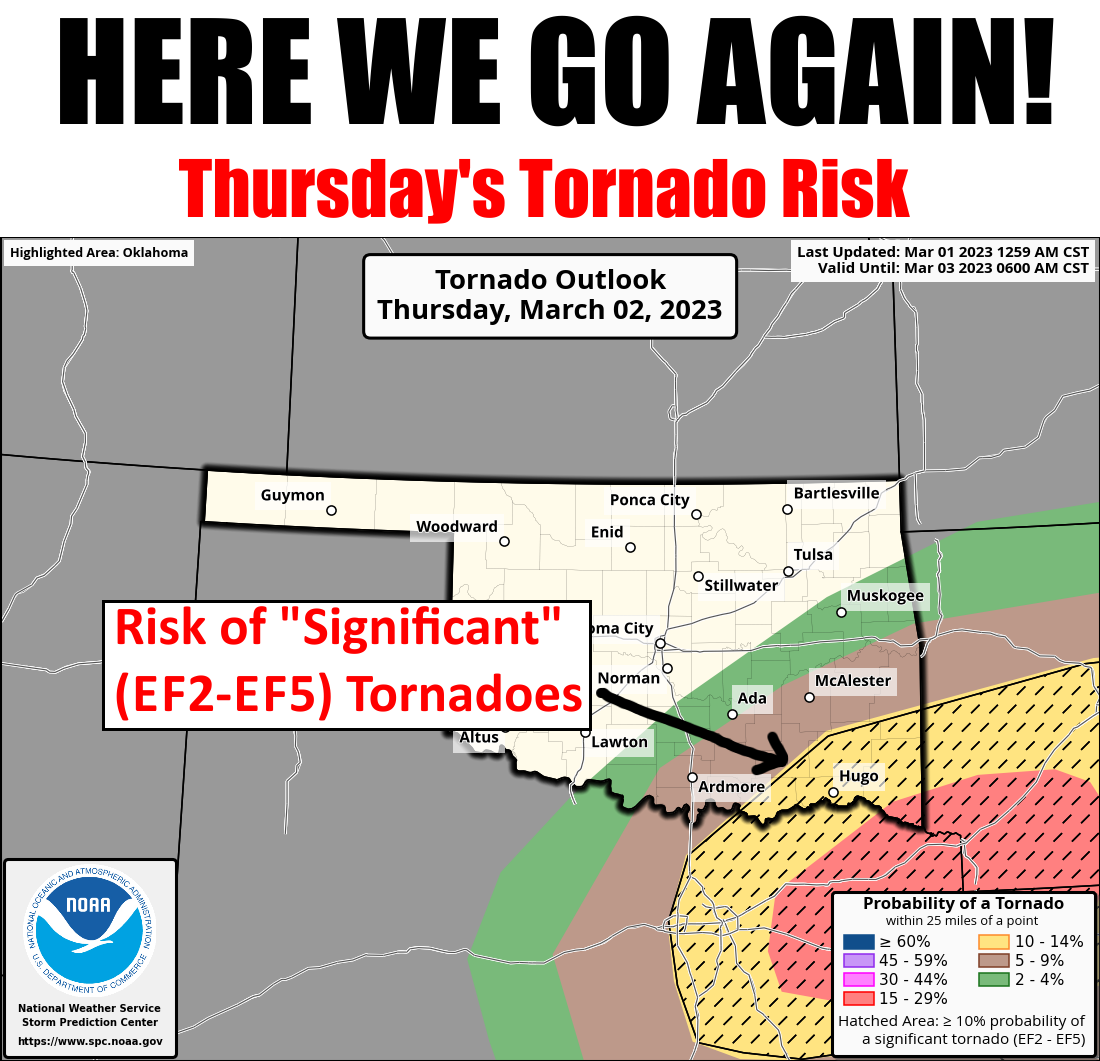
Tornado Repeat?
https://ticker.mesonet.org/archive/20230301/OK_swody2_TORN.png
Yes, brought to you by the same people (AHEM! Looking at you, Mother Nature)
that produced AT LEAST 10 tornadoes in February (breaking the previous record
of 6 from 1975 and 2009), a record 5 tornadoes in January, AND a record 8
tornadoes in Decemeber!
Yeah, that's right...three straight months with a record number of tornadoes.
Let me repeat that, so it will sink in.
"...that, so it will sink in."
But also "THREE STRAIGHT MONTHS WITH A RECORD NUMBER OF TORNADOES!" This is an
odd thing to say, but at least it was the low-count winter months. I would
mention November had 6 tornadoes (not a record, but well above the average of
1.6) as well, but that'd just be rubbing it in. So we had 23 tornadoes during
the climatological winter (December-February) of 2022-23...average is 1.5 and
previous record was 7 from 1974-75, 1975-76, and 2008-09.
What's up with all these tornadoes? DAMN IT, JIM, I'M A CLIMATOLOGIST, NOT A...
oh wait, I guess I should know. All I can figure out is it has been mostly
warm through the last 3-4 months, we've had plenty of moisture, and an extremely
active southern-track jet stream. All the moisture and temperature stats are
included below in the February summary.
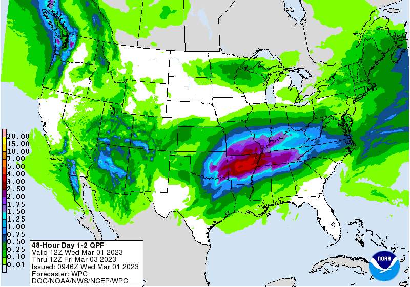
I don't know what it means for the rest of the year, and more importantly, the
normally-active spring months ahead. It might not mean anything, but with yet
another powerful storm system barreling toward the state, my overly-educated
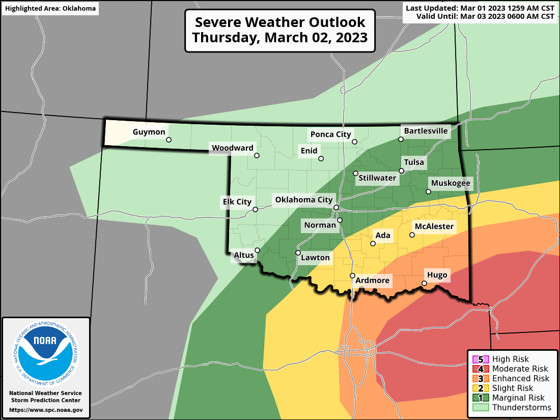
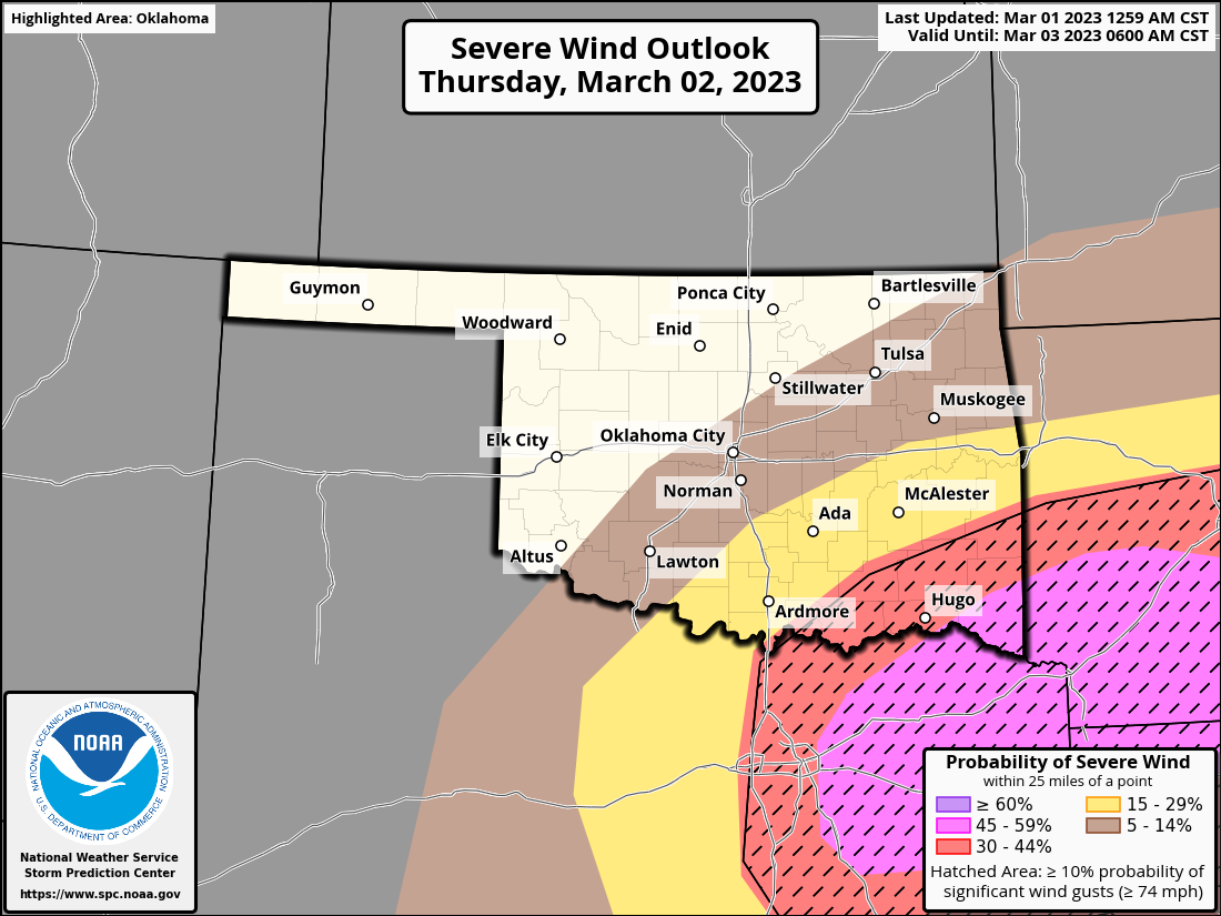
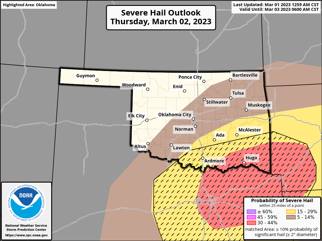
guess is it ain't good. The storm's tomorrow have a chance yet again of
producing strong tornadoes, mainly in the SE corner of the state. An increased
risk of large hail and damaging winds is also present. Keep in mind (ALWAYS)
that this forecast could still change...shift or spread northwest, lessen in
expected strength, or as the last one did, strengthen even more.
https://ticker.mesonet.org/archive/20230301/OK_swody2.png
https://ticker.mesonet.org/archive/20230301/OK_swody2_WIND.png
https://ticker.mesonet.org/archive/20230301/OK_swody2_HAIL.png
I would say there's a decent chance our tornado numbers go up, which they're
almost certain to do anyway as the NWS folks continue to investigate possible
tornadoes from last Sunday. We do need the moisture, but more so up in NW OK,
where "not a lot" is expected.
https://ticker.mesonet.org/archive/20230301/2day-moisture-forecast.gif
Stick around below for some pretty amazing stats about our warm, wet February
and winter, and crazy tornado numbers.
That's it...I'm done. Tornadoes, however, are not.
----------------------------------------------------------------------------------
Historic February Tornado Outbreak Strikes Oklahoma
March 1, 2023
A potent storm system—labeled by forecasters as “historic” and “unprecedented”
for February—struck Oklahoma on Feb. 26 with the full fury and power of a
classic springtime severe weather outbreak. At least 10 tornadoes were confirmed
during the event, with that total almost guaranteed to creep higher with further
investigation by National Weather Service personnel. The preliminary total of 10
shatters the previous February record of 6 set in both 1975 and 2009. Accurate
tornado records for Oklahoma date back to 1950, and the long-term average for
February is 0.3. The storm—which previously brought record snows to Southern
California—seemed to pinpoint populated areas across the state with a
combination of tornadoes and damaging straight-line winds. State officials
reported at least 55 weather-related injures on the day. One fatality was
reported when an EF2-rated tornado struck the small community of Cheyenne in
Roger Mills County and destroyed at least five homes. There were at least two
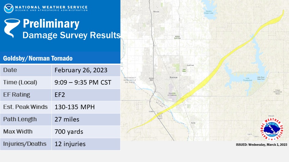
other “strong” EF2 twisters quickly confirmed by NWS investigations. The first
was on the ground for 27 miles from Goldsby through southeast Norman, reaching
a width of 700 yards. Emergency Management officials estimate 69 homes were
damaged in Norman, with 40 of those being destroyed. Apartment complexes
housing University of Oklahoma students were also damaged on the southeast side
of Norman. Twelve minor injuries were reported by local hospitals due to the
storm. The second EF2 touched down just north of Shawnee and remained on the
ground for 6 miles. That tornado, along with an EF1 that touched down just to
its west near McCloud, damaged 47 homes in the McCloud and Shawnee areas. Other
confirmed tornadoes struck near Amorita, Erick, Hollis, Lone Wolf, Tuttle, and
western Oklahoma City. There were numerous reports of straight-line winds
exceeding 75 mph. The Oklahoma Mesonet site at Fittstown recorded a wind gust of
86 mph, and a media chase vehicle reported a wind gust of 111 mph near Hobart.
At the height of the severe weather outbreak, more than 76,000 power outages
were reported across Oklahoma.
https://ticker.mesonet.org/archive/20230301/nws-norman-goldsby-norman-tornado.jpg
February was not the only recent month that broke its tornado record. In
astounding succession, December 2022 and January 2023 also broke their previous
records with 8 and 5 tornadoes, respectively. That December-February preliminary
total of 23 tornadoes—with that number almost certain to rise—obliterated the
previous climatological winter record of 7, set back during the winters of 1974-
75, 1975-76, and 2008-09. The 15 tornadoes during January and February also
broke the previous record of 7 from the first two months of 1975. The January-
February long-term average number of tornadoes is 1, and the climatological
winter average is 1.5.
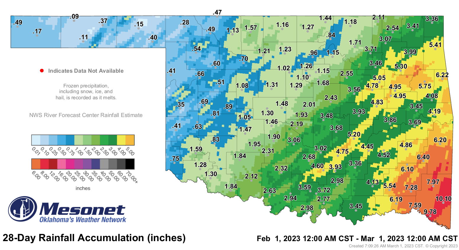
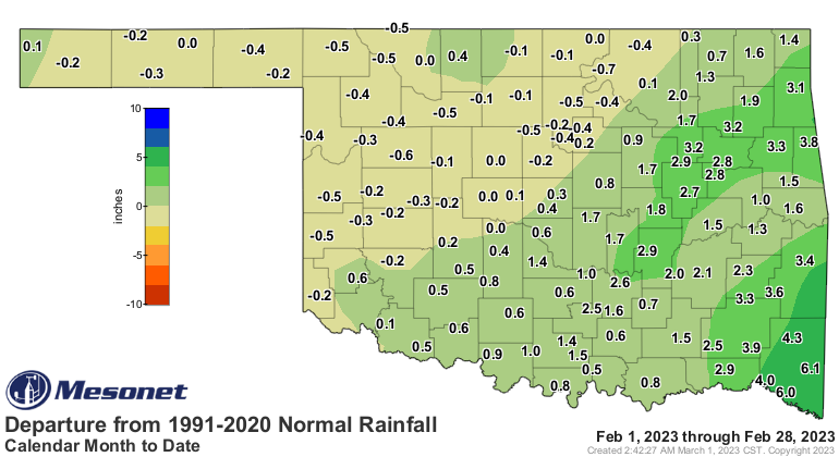
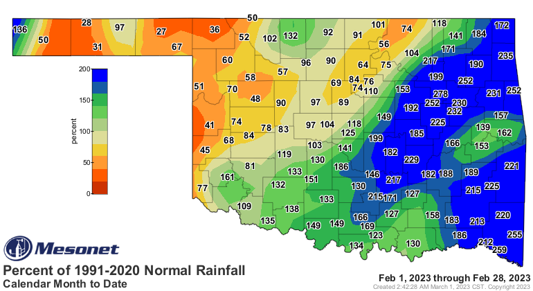
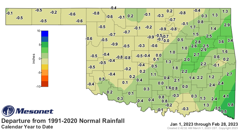
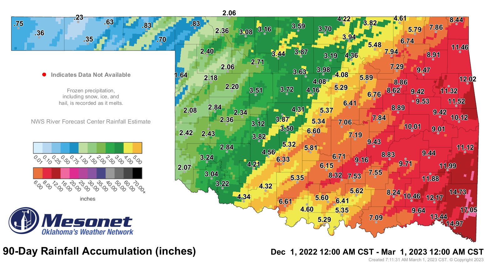
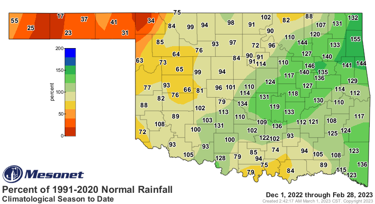
The statewide average precipitation total of 2.58 inches was 0.75 inches above
normal and ranked the month as the 21st wettest February since records began in
1895. Hefty surpluses of 1-3 inches were observed across roughly the
southeastern half of the state, with deficits of up to a half-inch across the
northwestern half. Broken Bow led the state with a whopping 10.1 inches, 6.1
inches above normal. Eva had the lowest total at 0.09 inches. Twenty-eight of
the Mesonet’s 120 sites recorded at least 4 inches of rain for the month, and
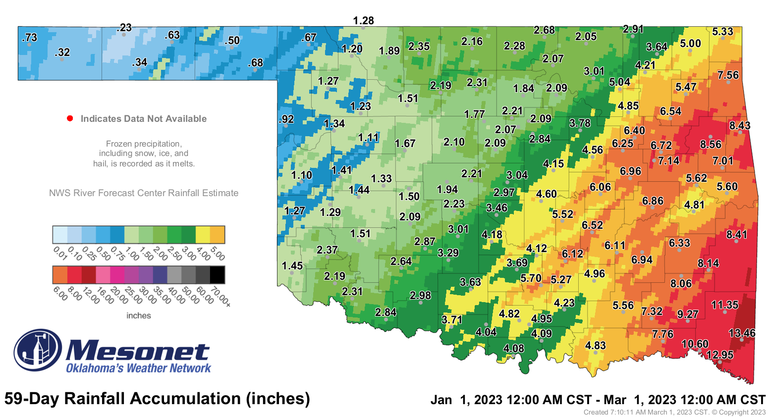
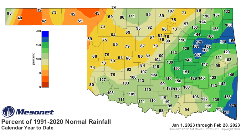
another 20 reported at least 3 inches. January and February combined had a
statewide average of 3.8 inches, 0.41 inches above normal and ranked as the
34th wettest such period on record. Climatological winter finished at 5.66
inches, 0.21 inches above normal and ranked as the 42nd wettest December-
February on record.
https://ticker.mesonet.org/archive/20230301/feb-rain-totals.png
https://ticker.mesonet.org/archive/20230301/feb-rain-depart.png
https://ticker.mesonet.org/archive/20230301/feb-rain-pct.png
https://ticker.mesonet.org/archive/20230301/jan-feb-rain-totals.png
https://ticker.mesonet.org/archive/20230301/jan-feb-rain-depart.png
https://ticker.mesonet.org/archive/20230301/jan-feb-rain-pct.png
https://ticker.mesonet.org/archive/20230301/winter-rain-totals.png
https://ticker.mesonet.org/archive/20230301/winter-rain-depart.png
https://ticker.mesonet.org/archive/20230301/winter-rain-pct.png
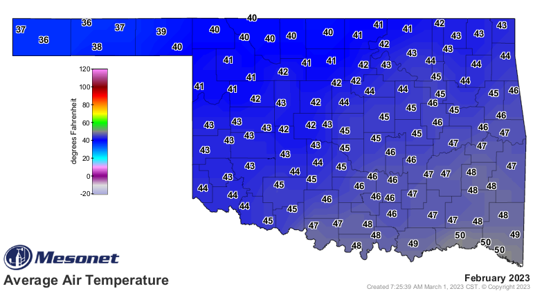
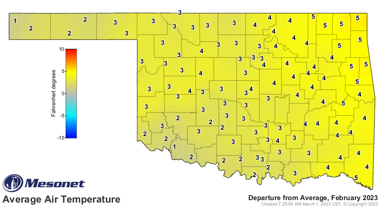
The statewide average temperature for the month was 44.1 degrees, 2 degrees
above normal and ranked as the 32nd warmest February since records began in
1895. Temperatures ranged from 87 degrees at Burneyville on Feb. 21 to minus 1
at Kenton on Feb. 17. Prolonged cold snaps were limited during the month. The
Mesonet’s 120 sites reached at least 80 degrees 55 times across 4 separate days
during February, and 70 degrees 665 times across 12 separate days. The first two
months of the year had a statewide average of 42 degrees, 2.6 degrees above
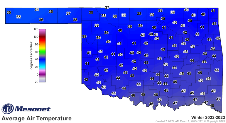
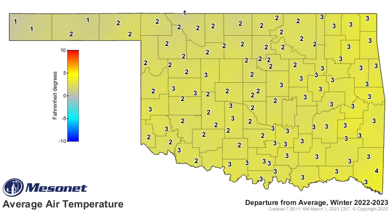
normal and ranked as the 20th warmest January-February on record. Climatological
winter’s statewide average was 43.1 degrees, 3.3 degrees above normal and ranked
as the 14th warmest such period on record. The highest temperature recorded
during Winter 2022-23 was the 87 degrees at Burneyville on Feb. 21, and the
lowest was minus 7 degrees recorded at four separate locations between Dec.
22-23, 2022.
https://ticker.mesonet.org/archive/20230301/feb-avg-temps.png
https://ticker.mesonet.org/archive/20230301/feb-temps-depart.png
https://ticker.mesonet.org/archive/20230301/winter-avg-temps.png
https://ticker.mesonet.org/archive/20230301/winter-temps-depart.png
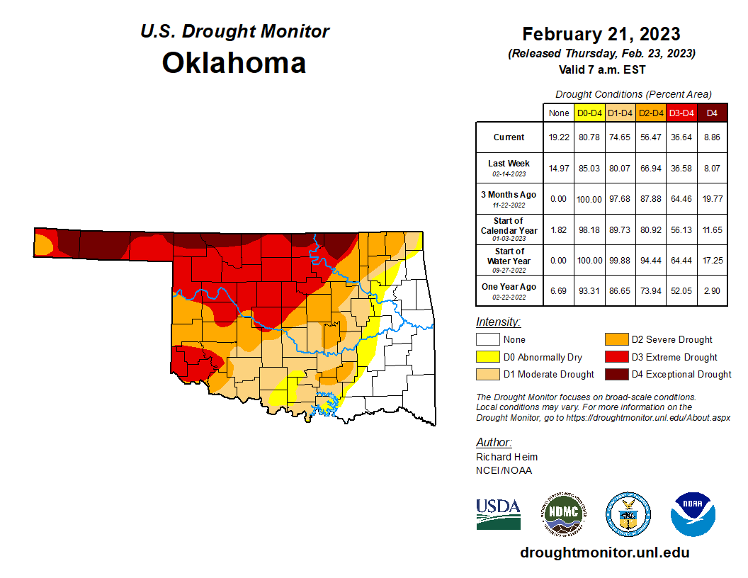
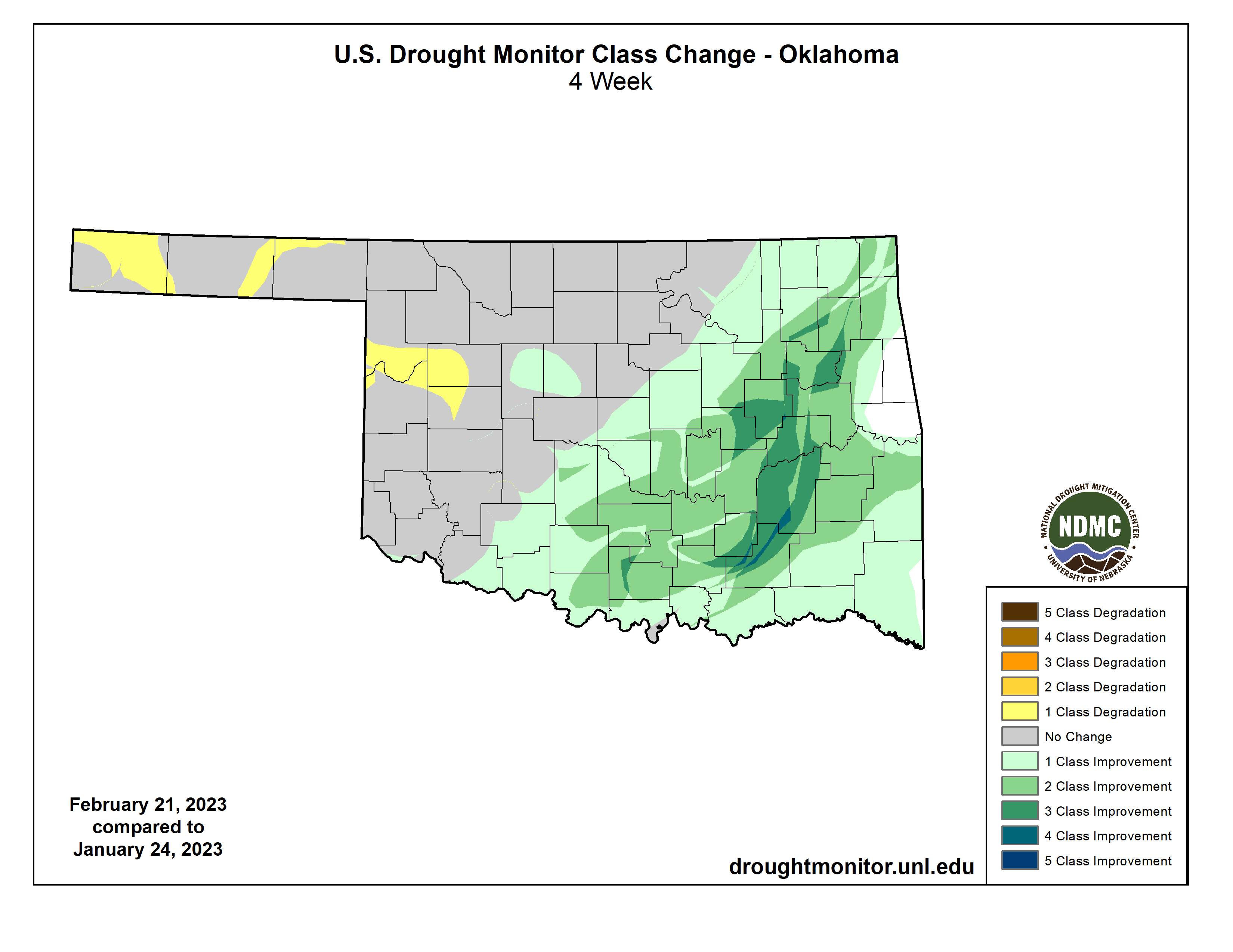
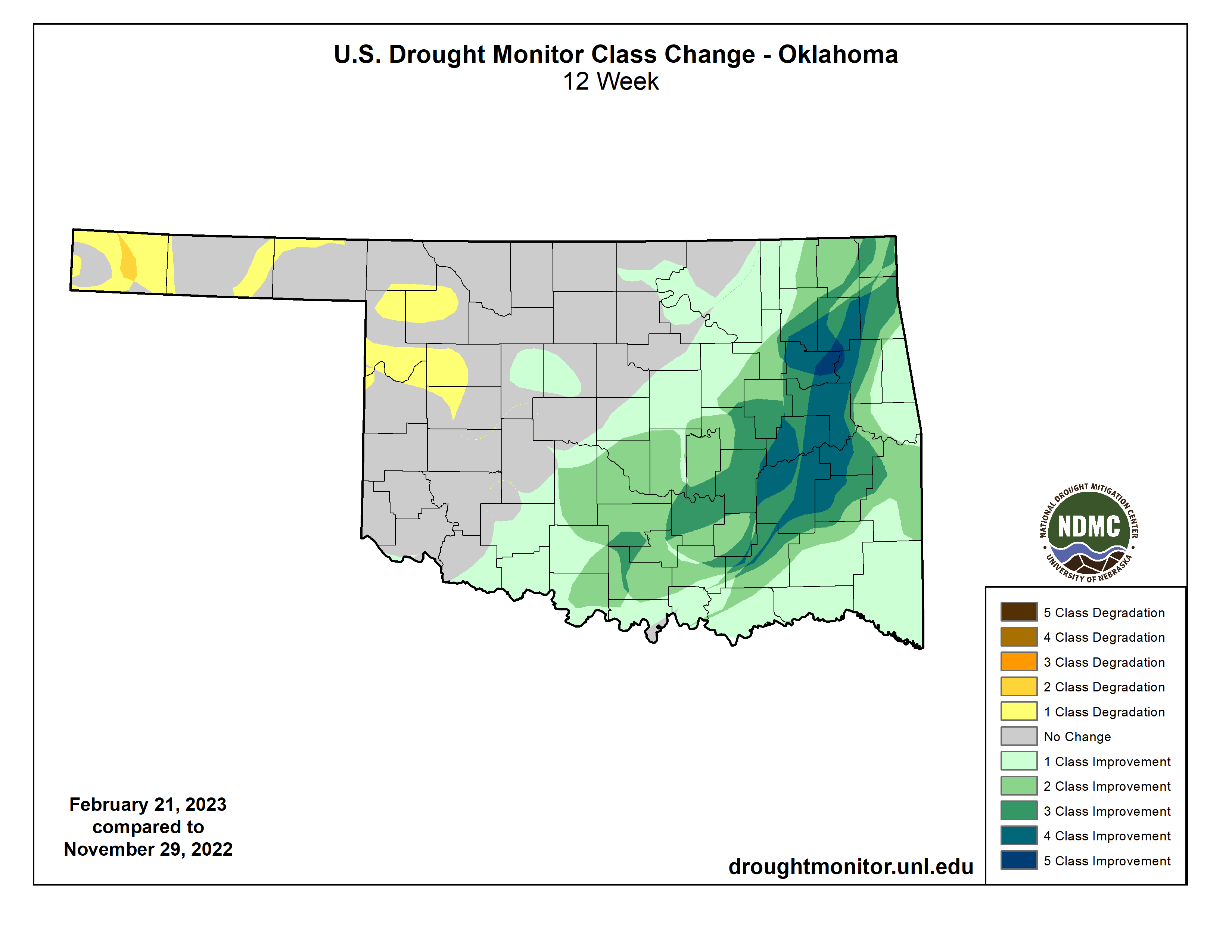
Drought coverage in Oklahoma was reduced by a little more than 10% during
February according to the U.S. Drought Monitor, part of improvements across the
southeastern half of the state that were prevalent through the winter of
2022-23. Drought covered 91% of the state at the beginning of December 2022, and
85% at the beginning of February. February’s final Drought Monitor showed 75% of
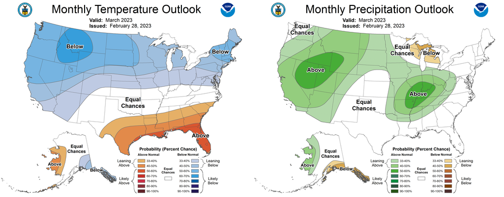
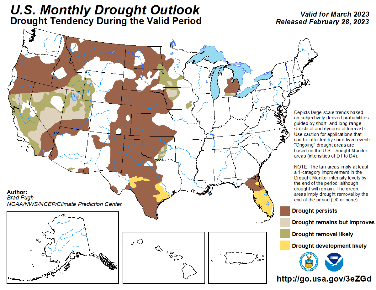
the state in at least moderate drought. The Climate Prediction Center’s March
temperature and precipitation outlooks don’t hold many clues other than
increased odds of above normal precipitation across the eastern one-third of
Oklahoma. CPC’s March drought outlook calls for some improvement of drought
from central through south central Oklahoma, but persistence across much of the
northwestern half of the state.
https://ticker.mesonet.org/archive/20230301/20230221_ok_trd.png
https://ticker.mesonet.org/archive/20230301/4week-DM-change.png
https://ticker.mesonet.org/archive/20230301/3month-DM-change.png
https://ticker.mesonet.org/archive/20230301/march-temp-precp-outloks.png
https://ticker.mesonet.org/archive/20230301/march-drought-outlook.png
###
Gary McManus
State Climatologist
Oklahoma Mesonet
Oklahoma Climatological Survey
gmcmanus@mesonet.org
==================================================
The OCS/Mesonet Ticker
https://ticker.mesonet.org/
To subscribe or unsubscribe from the Ticker
or for questions about the Ticker or its content
Phone or Email the Ticker Manager at OCS
Phone: 405-325-2253 Email: ticker@mesonet.org
---------------------------------------------------
-C- Copyright 2024 Oklahoma Climatological Survey
===================================================
|


 Tweet
Tweet